
Share this:
Drainage Basin

Processes of erosion and transportantion in a river
Attrition – material is moved along the river bed. It collides with other material and breaks into smaller pieces
Corrasion – Fine material rubs against the river bank. The bank is worn away and collapses
Corrosion – Some rocks forming the banks ands bed of a river are dissolved by acids in the water
Hydraulic action – The sheer force of water hitting the river banks
Traction – large rocks and boulders are rolled along the river bed
Saltation – smaller stones are bounced along the river bed in a leapfrogging motion
Suspension – Fine material, light enough to be carried by the river. Solution – dissolved material transported by the river
What landforms are created in the Upper Course?
1 – Interlocking Spurs
(Oblique Front View)
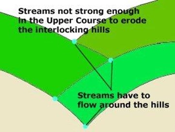
Interlocking spurs are alternate hills in the river valley. The river does not have a high water volume at this point and even though it is fast flowing, the river cannot laterally erode (sideways) to remove the spurs. Because of this, the river has to flow around the spurs, eroding vertically.
2 – Waterfall and Gorge (1)
(Oblique Front View)

In the Upper Course, the river is not only eroding vertically (down) but towards its source (HEADWARD EROSION). This means the feature shown in the diagram above is created. The river erodes the softer rock underneath the harder rock on top faster, and this means the level of the land along the river’s course becomes lower over time and the waterfall retreats back towards the source. Successive positions of the waterfall are shown on the diagram. The movement backwards leaves a second feature called a GORGE.
2 – Waterfall and Gorge (2)
(Side View)
Looking at a side view, the process becomes clearer. Splash back from the falling water erodes away the softer rock faster, leaving the hard rock without support and it collapses into the plunge pool. The process then repeats itself, with the waterfall further towards the source of the river.
What landforms are created in the middle course?
1 – Meanders (1)
![]()
(Aerial View)
Meanders are created by the lateral erosion that the river undertakes in this
part of its journey to the sea. Water flows around the bend in the river and as it does so, it swings to the outside of the bend (at X on the above diagram – imagine it like a bobsleigh swinging to the outside of a snow run) – this means the fastest flowing and highest volume of water is concentrated on the outside of the bend causing it to erode the bank at this point. On the inside of the bend (point Y on the above diagram), the flow is extremely slow and because of this lack of energy, the river is depositing.
What is a meander?
Meanders are simply bends in a river’s course. They usually occur in the middle
and lower
course of a river and because of the way they affect the structure of the water velocity in the river channel, meanders create specific features. The main two are slip-off slope and river cliff.
Slip-off slopes are features of deposition. They are formed on the inside of a meander where the velocity is slowest. The current swings to the outside of the bend (like a toboggan).
The river cliff is formed on the outside of the bend where the current is at its fastest. The current erodes (undercuts) the river bank and this collapses, leaving a vertical slope.
1 – Meanders (2)
(Side View of Cross-Section X-Y)
This cross-section diagram clearly shows what is happening at the bend of a river. At point
X, the river’s flow is concentrated on the eroding the bank, creating a landform known as a RIVER CLIFF. On the inside, the deposition creates a landform called a SLIP-OFF SLOPE. The river is therefore eroding laterally (sideways and downcourse, as the river flow is concentrated forwards on the bend). This creates a large FLOODPLAIN in the river valley, as the lateral erosion is able to remove the Interlocking Spurs.
2 – Ox-Bow Lakes
(1)
(Aerial View)

2 – Ox-Bow Lakes (2)
(Aerial View)
Ox-Bow lakes are created by the processes at work in a river meander where two River Cliffs are eroding towards each other. Eventually, this will breach and the water will flow along the straightened course. In the river bend, the water stops flowing, and this loss of energy means the river deposits its load – this creates ‘plugs’ at both ends of the meander and creates a lake. This lake will silt up and evaporate away to leave an ‘impression’ of a meander on the landscape.
In the Lower Course (Old Age or Plain Stage) , the river slows down as the gradient is almost flat. The river is no longer able to erode and therefore deposits its load and landforms in this course are features of deposition. The volume is the largest on the river’s course. This part of a river is liable to flood.
What landforms are created in the lower course?
1 – Leveés and Raised Beds (1)
(Front View)
1 – Leveés and Raised Beds (2)
(Front View)
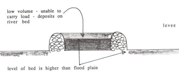
In the winter, when the river volume is at its highest, the river is prone to flooding. As the river overflows its banks, friction with the floodplain slows down the flow. The loss of energy means load is deposited. The deposition is graded – this means that the larger particles are dropped first (being the heaviest) near the river bank edge and the smaller particles are taken further along the floodplain. The larger particles build up over repeated flooding to create a leveé, which increases the capacity of the river.
However, in the summer when the river volume and energy is at its lowest, deposition occurs in the river channel, raising the bed. This means that the capacity of the river is lowered and flooding again will occur in the winter months, creating bigger leveés.
This cycle raises the river higher than the landscape over time.
3 – Delta
(Aerial View)

Deltas are formed when the river meets the sea. The sea does not flow, so the
river suddenly stops upon meeting the sea and loses its energy to carry load. The load is then deposited on the sea bed and over time, this builds up to form a new piece of land in the river mouth. The river then has to divert its flow into smaller
‘distributaries’ to reach the sea again. When it does so, more load is deposited
and this builds the new delta out into the sea.
For a delta to survive, the river must bring a constant supply of material to deposit on the delta or it will be eroded away by the sea. Many human-made dams on rivers stop silt getting to deltas in this way.
How does a river flood?
A flood is simply when a river overflows because the amount of water in the channel is too much for the river to carry. This causes the water to flow out of the channel and over the surrounding land. It is actually a very important natural event, which is necessary for the adding of fertile material to farmland, but is perceived as a nuisance which causes damage to human property.
Flooding risk is measured in MAGNITUDES (amount) and FREQUENCIES (how often) and usually floods fall into categories such as high frequency – low magnitude (happening often, but only small) or low frequency – high magnitude (don’t happen often, but are major floods when they do) events.
The diagrams below are designed to show the terminology and stages associated with a flooding event and occur in the Lower Course.
1
This is a river in a normal flow. You can see that the water is contained within the channel in the lower course. The terminology associated with this stage is:
2
More water has entered the river, increasing the discharge. Heavy rainfall, snowmelt or other event has increased the flow. You can see that the river is now at its fullest level or BANKFULL capacity, rather like filling a glass to the brim. This is the maximum amount of water that the river can carry. Any more and the flood will take place.
3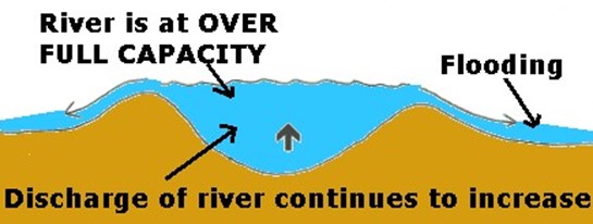
Even more water has entered the channel and the river is unable to discharge the amount of water successfully. The water overspills the levées and a flood
occurs, where load is dropped onto the floodplain. This load raises the levées and grades the floodplain. The load dropped is called SILT or ALLUVIUM, and makes the floodplain a fertile place for agriculture.
FLOODING
Case study – MISSISSIPPI
In the summer of 1993, the Mississippi River in the USA burst its banks.
- 150 levees (embankments) collapsed under the pressure of water.
- Dams burst and bridges were closed. By mid July 100 tributaries had flooded and the Mississippi spread across the flood plain for 10 – 25 kilometres.
The effects of the flood were:
- 48 people were killed.
- Nine states were affected. Floodwater stretched from Memphis in the south to Minneapolis in the north – covering 23 million acres.
- 26.5 million sandbags were used.
- Almost 70,000 people were evacuated from their homes.
- Final damage costs were estimated at $10 billion. Over 25% of this was crop losses.
- Some areas never recovered. The town of Valmeyer, Illinois, was abandoned after the floods and rebuilt on higher ground.
- The river was closed to traffic for two months – 15% of the USA’s freight uses the Mississippi.
Exam tip
A typical exam question that uses this case study would be Describe the effects on people of a flood event you have studied. Make sure you name the place (river), country and date of the event.
The influences of nature and people
The climatic conditions leading up to the flood
- From April and all through the summer, record heavy rain fell across the north part of the Mississippi drainage basin. This was partly caused by high pressure system around Bermuda.
- Thunderstorms brought torrential rain in June and July adding to the rising waters. Rainfall in these two months was the highest since 1895.
The taming of the Mississippi
The Mississippi is a vital transport route running from north to south in the centre of the USA. Engineers have had to work to maintain a channel of water deep enough for river traffic and to control the river’s regular floods, protecting settlements and farmland throughout the river basin.
Engineers have altered the Mississippi in the following ways:
- ‘Wing dykes’ have been built to slow down the river on one side whilst speeding it up on the other, creating a deeper channel for navigation.
- Sections of the river have been straightened by cutting through meanders. The river is now 150 miles shorter.
- 1600 kms of levees (embankments) have been built to prevent the river spilling over the flood plain.
- Many dams and reservoirs have been built on tributaries to hold back and store
water.
- Much of the river has been lined with concrete slabs.
Did engineers cause these floods?
Despite all these control methods the flood of 1993 was the worst ever. Engineers called it a ‘one in a hundred’ flood caused by exceptionally heavy rainfall.
Many environmentalists argue that far from controlling the Mississippi, the engineers’ efforts have made things worse by:
- shortening the river, causing it to flow more quickly and increasing erosion.
- restricting the flow of water inside levees, speeding up the flow and increasing the pressure on the levees and the likelihood of flooding. In 1993 a large number of levees broke or were too low to stop flooding.
- altering the natural flow of the river to such an extent that the 1993 floods were the worst ever, even though there was less water in the river than during previous major floods.
- increasing the energy in the river, because there is less sediment being moved around.
Make sure that you know a case study of flooding in an LEDC – Bangladesh 1998! – write a case study file on this – use page 44-45 in your textbook to help.
Have a look at page 48 as a summary of how a river changes downstream.
Exam Tip: photocopy page 48 and cut up. See if you can put back together
(Without using the textbook obviously!)
GLOSS
ARY
![]() HYDROL OGY
HYDROL OGY
|
|
Hydrological cycle | The cycle by which water moves between the earth’s surface and the atmosphere |
Closed system | No loss occurs from the system. The cycle does not lose any water, it has a fixed amount |
Open system | Loss of matter occurs from the system, water lost from the drainage basin system |
Drainage basin | The area of land drained by a river and its tributaries |
Watershed | Boundary of the drainage basin. A ridge of high land. It separates one drainage basin from neighbouring drainage basins |
Inputs | Water enters system through precipitation |
Outputs | Water is lost from system by rivers carrying it to the sea or by evapotranspiration |
Precipitation | Process by which water is transferred from the atmosphere to the earth’s surface in the form of rain, snow sleet or hail |
Interception | Incoming precipitation is trapped by vegetation and/or buildings |
Overland flow or surface run-off | Process by which water moves downslope over the earth’s surface |
Infiltration | Process by which water enters the earth’s surface |
Percolation | Process by which water moves vertically downwards through soil and rock |
Throughflow | Process by which water moves downslope through the soil under the influence of gravity |
Water table | The line marking the upper limit of saturation in the ground |
Groundwater | Water filling all pore spaces below the water table |
Groundwater flow | Process by which groundwater moves downslope below the water table under the influence of gravity |
Transfers | Water moves through the system from one place to another |
Storage | Water is held within the system |
Source | A point at which a river begins |
Tributary | A small stream or river flowing into a main river |
Confluence | A place where a tributary joins the main river |
Mouth | The end of a river where it meets the sea |
Attrition | Material is moved along the river bed. It collides with other material and breaks into smaller pieces |
Corrasion | Fine material rubs against the river bank. The bank is worn away and collapses |
Corrosion | Some rocks forming the banks ands bed of a river are dissolved by acids in the water |
Hydraulic action | The sheer force of water hitting the river banks |
Traction | Large rocks and boulders are rolled along the river bed |
Saltation | Smaller stones are bounced along the river bed in a leap-frogging motion |
Suspension | Fine material, light enough to be carried by the river |
Solution | Dissolved material transported by the river |
Meander | Sweeping curve in the course of a river |
Oxbow lake | Curved lake found on the flood plain of a river. Caused by the loops of meanders being cut off at times of flood and the river subsequently adopting a shorter course |
Lateral erosion | Erosion that occurs sideways instead of vertically |
| Naturally formed raised bank along the side of river channel |
Flood plain | Area that suffers periodic flooding along the course of the river. |
Delta | Feature composed of silt formed when sediment is deposited at the mouth of the river, caused by the slowing of the water on entering the sea. |
Distributary | River that has branched away from a main river. |
Aquifer | A rock which stores significant amounts of groundwater in its pore spaces |
Evaporation | Process by which water is transferred from the earth’s surface to the atmosphere |
Transpiration | Process by which water is transferred from vegetation to the atmosphere via stomata on leaves |
Evapotranspiration | The total output of water vapour from the drainage basin system to the atmosphere through the combined processes of evaporation and transpiration |
Storm hydrograph | Graph showing discharge against time following a single precipitation event. Comprises of a rising limb and a recession limb |
Lag time | The time between peak precipitation and peak discharge |
River discharge | The volume of water passing a given point at a given time. Calculated by multiplying cross-sectional area by average velocity. Expressed in cumecs (m/s3) |
Suspended load | Solid particles carried within the current, but not touching the bed |
Bedload | The coarser material carried along the bed of a stream by the force of the water. |


