Share this:
The drainage of Uganda Notes
Drainage refers to water logged areas of rivers, lakes and swamps. It is the different water sources in a country.
Uganda has got different drainage systems of lakes such as Victoria, Kyoga, Albert, Bisiina, Wamala, etc rivers such as Nile, Katonga, Kagera, etc. and Swamps like along rivers and lakes, others like Rubigi, Nabajuzi, kirihili, etc.
Distribution of drainage system in Uganda
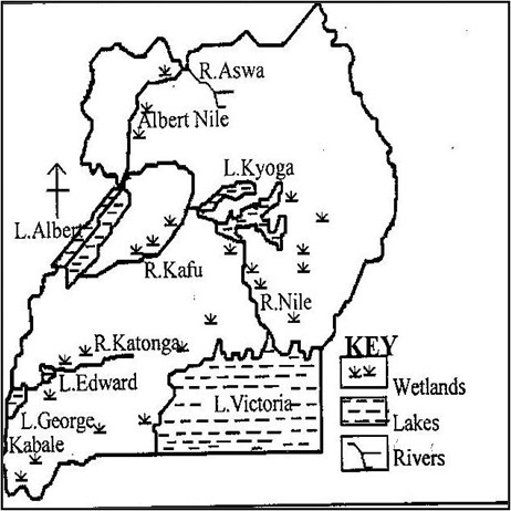
Lakes
A lake is a body of water contained in a hollow with in a basin.
The size, depth and permanence of a lake depend largely on the nature of the basin on which it’s located. In Uganda, there are various lakes like Victoria, which is the largest, Kyoga, Wamala, Albert, George, Edward, Mburo, Bisiina and other volcanic lakes found in south western Uganda.
Lakes can be classified as;
- Depression/crustal warped lakes.
These include L. Victoria, Kyoga, Wamala and Bisiina.They are formed due to crustal warping in down warped basins.Such lakes are generally large and irregular in shape, shallow in depth, surrounded by swamps and their shorelines show influence of drowning inform of numerous inlets.
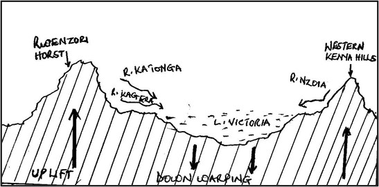
Formation of Lake Victoria
- Lake Victoria is a crustal warped lake located in a down warped basin in south eastern Uganda.
- Down warping and up-warping of the landscape in Uganda occurred due to an increase in the lateral compression force which affected the earth crust over a wide area.
- Down warping led to the formation of a great basin i.e. Victoria-Kyoga basin and the uplift led to the formation of uplands/plateau.
- Crustal warping also led to a general reversal in the drainage system of Uganda. Rivers such as Katonga, Kagera, Kafu, Mayanja which were originally flowing towards Atlantic Ocean reversed their water due to uplift of western Uganda to over flood the central basin. This led to formation of L. Victoria.
- Other rivers like Ruizi, Nzoia also reversed their flow due to uplift of the eastern Uganda to fill L. Victoria.
Illustration of crustal warping

- Tectonic lakes/ fault lakes.
- These are located in the rift valley occupying gradens formed by secondary faulting which was initially caused by tension and compression forces.
- Fault lakes are narrow and elongated in shape, boarded by steep sides or fault scarps, their waters are usually saline and inlets and outlets tend to be confined at their extreme end.
- Such lakes include Albert, George and Edward.
Formation of L. Albert
- L. Albert is a fault lake formed by faulting process due to tension and compression forces in the grabens within the rift valley.
- L. Albert found in western Uganda in the western rift valley is majorly believed to have been formed by compression forces due to its steep Butiaba escarpments.
- According to compression force theory, the existence of compression forces within the crust acted upon/pushed the adjacent blocks forming fault lines.
- The central block thrusted against the adjacent blocks forming an elongated depression/rift valley as illustrated.
Before faulting during faulting
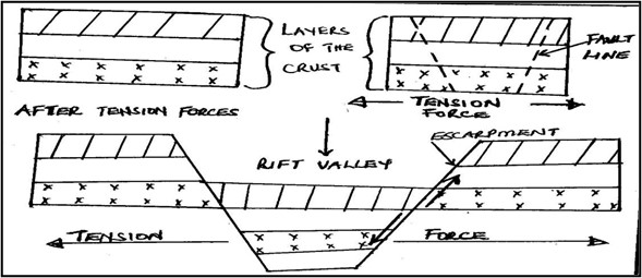
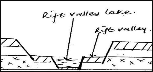
- Later secondary faulting acted upon the rift valley forming a graben/ a more defied depression.
- When the graben was filled with water, it became a rift valley lake known as L. Albert.
- Volcanic lakes.
These are formed by volcanicity and occupy craters and calderas formed as a result of eruption.
When the created craters or calderas are filled with water they form crater lakes or caldera lakes.
These include Lakes like Katwe, Nyungu, Nyamurangira, Nyamunuka, Kyamwoga, Munyanyange, and Nyamusingira all in south western Uganda.
Lava dammed lakes are formed where lava flow blocks the flowing river and floods a valley to form a lake such as Bunyonyi in Kabale, L. Mutanda, Butera, Muhondo, Mulehe, Ndalaga, all in south western Uganda.
- Glacial lakes.
These occupy cirques on high mountains of Rwenzori formed by glaciations process. The constant erosion caused by glaciers on this snow capped mountain of the moon, shallow steep sided depression are created known as cirques. When these are filled with water, glacial tarns are formed. Examples include Lac du Speke, Lac Catherine, Lac Noir and Lac Vert all on slopes of Mt. Rwenzori in western Uganda.
- Weathered lakes.
Chemical weathering act on some rocks especially limestone and make them break. In such places large pits are created/formed, when the pits are filled with water small lakes known as solution lakes are formed like in Nyakasura south western Uganda.
- Manmade lakes.
These are lakes made where man digs large depressions like Kabaka’s lake in Rubaga-Kampala and L. Kibimba in eastern Uganda.
Other lakes were formed through digging fishing ponds like in Mawogola and Kapchorwa in eastern Uganda. Others were formed as valley dams like in Nyabushozi, Kashari and Isingiro in south western Uganda.
- Deposition lakes or ox-bow lakes.
These are formed as a result of erosion and subsequent deposition along the lower course of a river. Such lakes are usually shallow and small and sometimes temporary. Ox-bow lakes formation is guided by meandering of a river as illustrated;
Meandering river and deposition
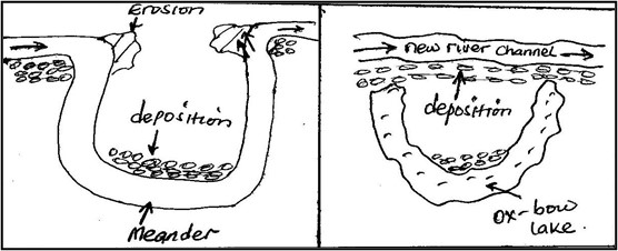
Examples of ox-bow lakes in Uganda have been found on rivers such as Semulik near Rwenzori and on R. Ruizi near Mbarara town.
Economic valsue of lakes in Uganda
- Lakes in Uganda have got both positive and negative values to the economic development of Uganda and these include;
- Lakes such as Victoria modify the climate of the surrounding areas along its shores of Mukono, Buikwe, Jinja, etc. through the process of evaporation and its breezes it forms heavy and reliable convectional rainfall supporting tea growing at Kasaku and sugar at Kakira for foreign exchange.
- Lakes provide water for irrigation at Lugazi sugar estate from L. Victoria, water to cool machines in steel rolling in Mukono and as a raw-material in Uganda breweries at Luzira from L. Victoria. Such industries have been source of consumer goods to Uganda reducing on imports.
- The water provided by lakes like Mburo has been used for animal consumption by the pastoralists in Kiruhura and by Mburo National park animals. This has diversified Uganda‘s economy through tourism and livestock farming. Also water from L. Victoria is used by Kampala and Masaka for domestic purpose.
- Lakes provide cheap water transport which has helped to promote trade and international relationship. Forexample L. Albert link Butiaba in Uganda to Muhanga in Congo, L. Victoria connects Jinja and Port bell of Uganda to Mwanza in Tanzania and Kisumu of Kenya.
- Lakes makes it possible for the generation of HEP like L. Victoria act as a reservoir for R. Nile where Owen falls dam and Bujagali dam are built.
HEP in turn has led to industrialization in Jinja and Kampala for jobs and government revenue.
- The papyrus vegetation and other swampy vegetation around lakes Kyoga and Victoria has led to the development of the craft industry were mats, roofing papyrus mats, etc are made. This has availed jobs to locals earning incomes for better living standards.
- The fresh water lakes of Kyoga and Victoria have provided fish such as Tilapia and Nile perch for proteins and development of the fishing industry. This has led to growth of fishing site like Lambu, Kasenyi, Jinja, Luzira, on Victoria and Lwampanga on Kyoga thus infrastructure development.
- Due to reliable rainfall provided by lakes such as L. Victoria, there has grown a dense forest within i.e. Karangara and Ssese islands forests and around the lake like Mabira. This has developed the forestry industry for job provision and economy diversification.
- Sand which is found at the shores of L. Victoria is used for construction purpose and glass making. Salt mining in L. Katwe, oil Prospects in Albert shores, clay mining in Kajjansi for ceramics on L. Victoria shores, all provide jobs to Ugandans, foreign exchange and infrastructure development.
- Lakes provide natural habitats for millions of plants, animals and birds. This promotes eco-system like at L. Mburo and George. The above coupled with the blue waters and beautiful scenery f lakes like Bunyonyi in Kabale, coastal features of beaches like Liddo, Nabugabo, on Victoria attract tourists for foreign exchange.
- Lakes provide great opportunities for research and study purpose in relation to fisheries, forestry, navigation and soils. There is also a meteological department at Entebbe thus weather studies which all help Ugandans understand their environment and make proper planning especially in the farming sector.
The short comings of lakes to Uganda‘s development include;
- Lakes are dumping grounds for industrial wastes like Uganda breweries factory at Port Bell in Luzira dump its wastes into Lake Victoria which pollutes its waters becoming un condusive for domestic use and fish existence.
- Navigation on lakes is associated by a number of accidents caused by strong winds like on L. Albert claiming a lot of important labor in form of people who would be productive for development.
- Lakes are barriers to construction of transport networks of roads and railway. Foristance L. Bunyonyi has made some parts of Kabale remote and backward. The low levels of infrastructure in such areas lead to low trade development and low Uganda‘s development.
- The swampy vegetation on crescents of lakes like Kyoga are breeding grounds for dangerous pests like mosquitoes and tsetse flies. Such pests transmit human diseases such as malaria and sleeping sickness respectively to people in Lwampanga on Kyoga.
- Sometimes lakes over flood their shorelines and this leads to property destruction and loss of lives. Foristance L. Bisiina flooded in 2007 causing water borne diseases to people in the area.
- Lakes that are shared by different countries like Albert and Edward by Uganda and Congo, Victoria by Uganda, Kenya and Tanzania, cause conflicts especially during usage of the lake in fisheries, transport and mining as it was between Uganda and Kenya over Mijingo island and on Albert with Congo.
- The changes in water levels lead to submergence and emergence of water which leads to destruction of ports as it has been on L. Albert.
- Some lakes like Albert and George fault lakes have got saline water and fault scarps along their shoreline which discourage fishing activities hence low development of the fishing industry.
- Lakes also harbour dangerous wild animals such as snakes, crocodiles and hippos which destroy crops and claim people’s lives like in L. Albert and Edward.
QN. Discuss the formation of Kyoga basin and examine the economic viability of the lake to the region where it is located.
Approach
Define a lake.
Identify where Lake Kyoga is found and some of the landing site on the lake.
Locate the lake differently shaded on the map of Uganda with other lakes. Make sure you indicate its landing sites.
With aid of diagrams explain its formation.
Explain with examples the positive and negative importance of the lake MAJORY to the region where it is located.
Rivers
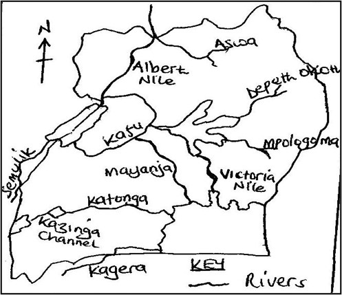
Uganda is drained by various rivers almost the entire landscape of the country. They are majorly nine rivers which include;
- R. Nile which include Victoria Nile and Albert Nile. It has its source in L. Victoria and its mouth in Mediterranean Sea.
- R. Katonga which flows from L. George to L. Victoria.
- Mpologoma-Manafa River, which originates from Mt. Elgon to L. Kyoga.
- Mayanja-Kato River, which has its source in L. Victoria and its mouth into Kafue.
- Aswa-Moroto River, it originates from north eastern Karamoja areas to R. Nile.
- R. kafue which originates from L. Kyoga to L. Albert.
- R. Kagera, it originates from Rwanda hills to L. Victoria.
- Depeth-Okoth which originates from Karamoja hills to Kyoga.
- R. Semulik and Mubuku.
Other rivers in Uganda include R. Rwizi, R. Sezibwa, R. Okere, Birira River, Nyamwamba, etc.
Major rivers in Uganda
River profile
This refers to the measured slope along the bed or surface of the river from its catchment area to its mouth. A river profile is divided into three sections i.e.
- The youthful stage
- The mature stage
- The senile stage.
During the erosion and deposition of a river there are different features formed i.e.
Waterfalls such as Owen falls, Bujagali falls and Muchison falls on R. Nile, Sezibwa falls on R. Sezibwa, Kisiizi falls, etc are formed by river erosion.
River deposition especially in its lower stage form ox-bow lakes as at R. Rwizi, deltas, etc.
Drainage patterns
A drainage pattern is a lay out plan which is made by a river and its tributaries on the landscape. In Uganda, the different patterns can be identified;
- Dendritic drainage pattern
- Radial
- Trellis
- Centripetal
- Annular
- Barbed
N.B River rejuvenation refers to a renewed river capacity in a river valley. Rejuvenation can be caused by heavy rains and river capture.
River capture or piracy refers to the diversion of part of a river course or whole of it into the system of another adjacent powerful river.
Economic value of rivers in Uganda
- Rivers are source of water for domestic, industrial and recreation purpose. Foristance Mbarara town get water for domestic use from R. Rwizi, Nile breweries use water from R. Nile as raw-material in making beer hence provision of jobs to Ugandans and government revenue.
- The water from rivers like Mubuku and Manafa is used to facilitate irrigation at Mubuku irrigation scheme in Kasese and Doho in eastern Uganda respectively. Such schemes have increased on food production and foreign exchange after rice and vegetable exports.
- Rivers facilitates generation of HEP like Owen falls dam and Bujagali dams on R. Nile, Mubuku power station on R. Mubuku, etc. HEP has lead to industrial development thus infrastructure development and jobs to Ugandans.
- Rivers provide cheap water transport by ferry means like on Victoria Nile. This has developed local trade, provided incomes to transporters hence improved living standards.
- The papyrus swamps which develop along river banks such as on R. Katonga and Mpologoma are potential raw-materials for paper, packing, cardboards, roofing materials and the general development of the craft industry thus employments to Ugandans.
- Rivers are tourist attraction especially waterfalls of Murchison, Bajagali, Sipi and Karuma falls. The meandering nature of R. Rwizi attracts tourists for foreign exchange in terms of invisible export which is used for further development.
- Rivers like Nile provide fishing grounds and fish caught for local consumption and for sale. The swampy areas along R. Katonga provide mud fish, which provide proteins and sold for better incomes to Ugandans.
- The swampy areas and wetlands along river channels are natural habitats for wild animals, birds and other marine life. Shoe bills and crested cranes survive in R. Nile wetlands attracting tourists for foreign exchange.
- There is clay mining along rivers like Katonga and Mpologoma for brick laying thus development of small scale industries for jobs to Ugandans.
- Rivers like Nakivubo channel help to regulate the environmental impurities that would directly enter L. Victoria leading to its pollution. Also rivers modify the climate where they exist like river Manafa form reliable rainfall which supports rice and other crop growing in eastern Uganda.
- River banks like Albert Nile have got fertile soils in West Nile areas supporting tobacco and other crop growing. This also has attracted settlement in the areas of Nebbi, Arua, etc. the grown crops have contributed foreign exchange to Uganda through exportation.
The short comings of rivers include;
- Some rivers tend to over flood their valleys during rainy seasons as it was in 2007 in north eastern Uganda and in 2014 in Kasese by R. Nyamwamba. This cause property destruction, loss of lives and interfere with transport networks since floods wash away bridges.
- Most rivers contain waterfalls and rapids like along Nile at Karuma which make navigation impossible thus resulting into remoteness and inaccessibility of such areas.
- Most rivers like in northern Uganda make the construction of feeder roads hard like at Karuma Bridge which makes such areas remote and inaccessible especially during rainy seasons.
- The swampy vegetation along river channels like along Katonga harbour disease vectors such as mosquitoes and tsetse flies which cause diseases such as malaria and sleeping sickness respectively to human beings.
N.B The economic importance of the drainage system of Uganda includes;
- Values of lakes
- Values of rivers
- Values of swamps
WETLANDS IN UGANDA
- Wetlands develop swampy vegetation in Uganda. Wetlands are water logged areas with plant life adapted to the environment.
- Wetlands are grouped as lacustrine i.e. those along lakes such as along L. Victoria like Lutembe, Nabugabo, Lambu, etc, along L. Kyoga like Galiraya, Kagwara and Lwampanga wetlands. Riverine wetlands i.e. those on river banks such as along R. Nile, Katonga, Kagera, Kafu, Mayanja, Sezibwa, Mpologoma, etc. and Dombos wetlands which exist in open valleys such as Busega in kampala, kiruhili in Kabale, nyaruzinga in Rukungiri, Lubigi in Kampala, etc.
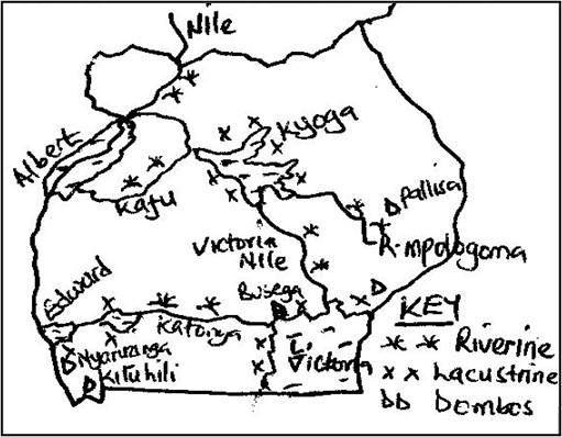 The extent of swamps and wetlands in Uganda
It should be noted that;
Status of wetlands
- There is a reduction of wetlands to 10%.
- Wetland cover 13% of Uganda.
- The dominant type of soil in wetlands is clay and sand.
- Most wetlands have turned into industrial parks such as Namanve, Manafa and Kyambogo.
- NEMA is the body responsible for wetlands in Uganda however it has done little to save Uganda‘s wetlands from destruction.
Economic importance of wetlands
- There is subsistence fishing carried out from swamps i.e. mud fish for consumption. This is majorly done along R. katonga swamps. Such fish provides proteins and is sold for cash thus improved living standards.
- Swamps through the process of evaporation leads to rainfall formation which modify the climate in areas of Lubigi, Nakayiba in Masaka, Lumansi in Bombo etc.this develops crop growing thus constant food supply in such areas.
- Swamps provide water for animal watering and also animal grazing during dry seasons like those along L. Kyoga shores to Baluli of Nakasongola.this has supported livestock thus incomes to farmers.
- Swamps provide grounds for crop growing such as yams in Busega, sugar canes, vegetables in kiruhili in Kabale. This has increased on farmers’ income improving on their standards of living.
- Swamps act as filters to protect lakes and rivers from pollution like Nakivubo swamp which protects L. Victoria from Kampala city sewerage. This ensures conservation of aquatic animals.
- Swamps provide natural habitat for thousands of marine animals and plants. They also protect rare bird species such as crested cranes and shoe bills. This has developed the tourist industry for foreign exchange.
- Wetlands like those around L. Victoria provide raw-materials for the making of crafts, mats and baskets. This has availed Ugandans jobs, earned incomes to the locals and development of the craft industry.
- Swamps are source f clay which has developed the making of tiles, bricks, pottery,etc like in Kajjansi-Wakiso district.
- Swamps provide water for domestic purpose like Nabajjuzi swamp which supply water to Masaka town. Lubigi swamp as well is source of water to Bwaise, kawala, Masanafu locals in Kampala reducing on city cost of living.
- Wetlands like Kasambya provide plants of medicinal value like aloevera which improves peoples’ health.
- Wetlands acts as boundaries for different districts like Kyoga wetland separates Bushenyi from Mbarara.
- Wetlands supports navigation like Lwampanga swamp which promotes trade.
- Wetlands act as hunting grounds for antelopes like along Kalinga
The short comings of wetlands in Uganda include.
- Swamps are breeding grounds of disease vectors of mosquitoes and tsetse flies which cause malaria and sleeping sickness respectively to human beings. This explains why many people in Bwaise, Kawala near Rubigi swamp suffer from malaria fever.
- Swamps like those along R. Katonga and Kazinga channel harbour dangerous animals such as snakes, crocodiles, hippos which claim people’s lives and destroy crops.
- Wetlands are usually over flooded during rainy seasons blocking roads like along R. Mpologoma and Manafa in Eastern Uganda.
- Swamps claim people’s lives as they drown from there. For instance many people have drowned in Rubigi swamp in the out skirts of Kampala.
- Navigable swamps like along Nile and Katonga have led to water accidents.
- Wetlands are affected by siltation and sedimentation which affect fishing and navigation like Lubigi and Lumbuye.
- Wetlands limit land uses such as settlement and agriculture due the floody nature like Nakayiba and Kyogya of Masaka which affect development.
- Many wetlands act as hiding places for anti government elements like robbers in Lwera-Masaka.
- Soils in most wetlands are acidic and un-productive and eaily lose fertility affecting crop growing and incomes like Nabajjuzi swamp in Masaka.
QN. Examine the view that the wetlands areas of Uganda are wasted lands.
Swamp reclamation in Uganda.
This refers to clearing of wetlands for man’s survival. This is happening to many swampy areas in Uganda such as Nabajuzi swamp in Masaka, Mutai swamp in jinja, Doho swamp, Kibimba swamp in eastern uganda, Nalukolongo, Kalerwe-Bwaise wetlands, Lumbuye wetland, Lwampanga wetland along Kyoga, mpologoma wetland along R. Mpologoma, Nakayiba in Masaka, Kiruruma in Kabale, etc it should be noted that wetlands in Jinja and Kampala are the most degraded.
Causes of swamp reclamation
- Crop growing purpose like Kakira sugar estate in jinja reclaimed Mutai swamp, Doho and Kibimba wetlands for rice growing in eastern Uganda and Kashambya swamps in Kabale reclaimed for vegetable gardens.
- Animal rearing especially during dry seasons like in Kitgum and parts of R. Mayanja, Mpologoma and Lwampanga wetlands have been encroached by the Baluli-Nakasongola pastralists and Kiruruma swamp in Kabale were leased to dairy farmers.
- Urbanization effect like in Bwaise, Kalerwe, Natete, Busega , New tax park areas have replaced wetlands where they exist in abit to extend Kampala city.
- Collection of craft materials and clay and sand excavation like in Kajjansi swamp by Uganda clays, the Lwera and Lutembe swamps have been threatened by sand mining.
- Industrialization like coca cola plant in Mbarara, bell factory in Luzira Port bell, Nalukolongo wetland claimed for Sembule steel rolling mills, Bwaise swamp for Avis cosmetics factory and many others in Nakawa and kyambogo in Kampala occupied Kyambogo-Mbuya wetlands.
- Settlement were many swamps hava been cleared for purposes of home construction like in Kisenyi and Kalerwe swamps in Kampala.
- Roads and infrastructure construction like the northern by-pass in kampala destroyed much of Lubigi swamp, kampala-Masaka road cleared part of katonga and Busega swamps, Jinja-Iganga-Tororo road destroyed parts of Walugogo, Lumbuye, Naigombya and Tirinyi swamps.
- Fire out breaks by farmers and hunters have degraded Katonga, Lwera, Tirinyi and other swamps.
- The practice of garbage disposal in wetlands by Kampala dwellers like in Kitezi wetlands, Luzira wetlands, Wakaliga, etc. Also Masese swamp in Jinja and Walugogo valley has suffered the same.
- The industrial discharge and pollution by the mining sector have degraded swamps like Njeru wetland Polluted by NYTIL and Nile breweries in Jinja and Kazinga and George wetlands have been degraded by cobalt wastes in Kasese.
Effects/problems associated with swamp reclamation in Uganda.
It has led to drying up of water wells and streams and lowering of the water table like in Butaleja, Pallisa and Iganga were Naigombya, Lumbuye and Mpologoma swamps have been reclaimed. This in turn is leading to the spread of the negative environmental phenomenon of desertification.
- It has led to a change in water quality of such swamps and wetlands. Also since wetlands act as a filter to lakes, their reclamation increases water pollution into lakes like Victoria affecting aquatic life.
- It has led to change in climatic regimes since swamp reclamation reduces rainfall received like in Pallisa and Iganga. This has discouraged crop growing and famine and drought are beginning to hit such places.
- Reclamation of swamps affects the life of thousands of marine animals and plants whose habitat has been removed. Foristance reclaiming of Kachido and upper Murchison bay wetlands, Lutembe wetland has affected crested cranes and migrant birds from Europe hindering tourism.
- The practice has led to floods in areas of Bwaise and Kalerwe, Kyambogo and Nakawa, etc. this has resulted into water borne diseases like dysentery, bilharzia and cholera in such areas of Kampala.
- Reclamation affects the source of building materials such as papyrus, sand and clay. This has resulted into high costs of building materials and construction like clay bricks from Kajjansi, Lweza and Kawempe are expensive.
- Swamp reclamation increases the rate of siltation of rivers and streams like in Walukuba, Makenke, and Magamag. Also the reclamation of Doho and Kibimba swamps has led to siltation of R. Manafa thus floods and loss of aquatic life.
- It leads to reduction in fishing grounds.
- Lowering of the water table which leads to drying up of streams and wells.
- Leads to easy spread of diseases since it causes pests invasion.
Measures to conserve wetlands in Uganda
- Practicing of family planning in order to control high population growth rate. This reduces on high demand for land thus reduced reclamation.
- NEMA has been set up to monitor wetlands and minimizes encroachment on wetlands. This helped to conserve Kyambogo, Bugolobi, Tirinyi and Naigombwa wetlands.
- Strict laws have been set up by the government against wetland encroachers. Evicting squatters in wetlands like from Bugolobi, Rufuha in Ntugamo, Agu wetland in Kumi has been done by government.
- Voluntary migrations have been encouraged i.e. from densely populated areas to sparsely populated areas. This has helped swamps to remain in their natural state.
- Massive education among the masses has been encouraged on the importance of swamps and their dangers especially to people of Busega, Kawoya wetlands in Banda, through public rallies, over radios and televisions.
- Encouragement of vertical expansion of Kampala city in Nalukolongo, Nakawa,Bwaise and Bugolobi has been done by KCCA.
- The UWA and NEMA have put a ban on hunting of wild animals and birds. This has minimized bush fires on Lumbuye, Naigombwa, Lubigi wetlands which were initially started by hunters.
- The government has gazette specific industrial areas like Kawempe, Namanve, Nakawa, Nalukolongo which has reduced on encroachment on wetlands.
- The national water and sewerage corporation is treating sewage at Bugolobi before it is released into Luzira swamps. Also KCCA has started proper garbage disposal in Kitezi saving Wakaliga swamp.
- NEMA is encouraging the covering pits left behind after sand and clay mining in Kasenyi, Kajjansi, Seeta and Luzira. Also the ministry of agriculture has introduced upland rice to discourage rice cultivation in Doho, Kibimba, Tirinyi swamps which claim wetlands.