Share this:
Relief and landform development in Uganda Notes
- Uganda lies on the African plateau at an average altitude of 1200m above sea level. In Uganda, the lowest altitude is found along L. Albert i.e. 620m above sea level and the elevated areas are found in Rwenzori Mountains i.e. 5000m above sea level.
- Other elevated relief areas are Elgon, Muhavura, and Moroto and much of the western Uganda i.e. Kigezi highlands of between 900m -1500m above sea level.
Uganda‘s relief is divided into related divisions i.e.
- Relief below 900m above sea level which constitutes 9% of the total land area of Uganda mainly found around L. Albert in the western rift valley arm.
- Relief between 900m-1500m above sea level which constitutes 84% of the total land area of Uganda majorly found in central, north and north east of Uganda.
- Relief between 1500m-2000m above sea level which constitutes 5% of the total land area of Uganda mainly found in the foot hills of Mt. Elgon and the Kigezi and western Uganda hills.
- Relief above 2000m above sea level which constitutes 2% of the total land area of Uganda majorly found at the peak of Mt. Rwenzori, Elgon Muhavura and Moroto.
Land forms
These were formed mainly due to Tectonism and Denudation processes.
Tectonism
Tectonism/ earth movement refers to all the disturbances of the endogenic origin. The endogenic processes which form what is referred to as tectonism include; Faulting, Vulcanicity, Crustal warping (down warping and uplift), Folding and Earth quakes.
Faulting
- It refers to the process through which the rocks within the earth’s crust are fractured, broken and displaced along the fault lines.
- This form fault land forms such as; The rift valley, Grabens , Rift valley lakes, Block Mountains, Fault scarps, Tilt blocks, Fault guided valley, etc.
- Indirectly, faulting lead to crustal warping, vulcanicity, earth quakes and glaciations.
- Faulting occur due to increased internal pressure and stress within the crust which is brought about by tension and compression forces.
- These forces cause the rock strata to fracture and break into large cracks or joints known as fault lines. There are mainly three types of faults produced i.e.
- Normal fault which is produced by tension forces
- Reversed faults which is produced by compression forces
- Tear faults/strike/wrench which is produced by lateral forces i.e. forces which acted past one another.
It should be noted that tear faulting led to formation of R. Aswa which is a fault guided valley.
Distribution of landforms of faulting in Uganda
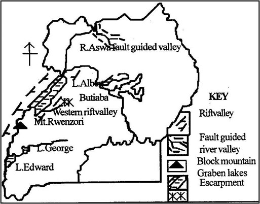
The rift valley and its formation
This is an elongated trough or depression which is boarded by in facing fault scarps on either side.
The western rift valley branch in Uganda covering Kanungu, Rukungiri, Bushenyi, Kasese, Nabbi, Masindi, etc was formed by faulting process.
The formation of the western rift valley
There are different theories put forward to explain the formation of the rift valley. These include;
- The tension force theory.
- The compression force theory
- The plate tectonism theory
- The differential uplift theory
- The basin and swell theory
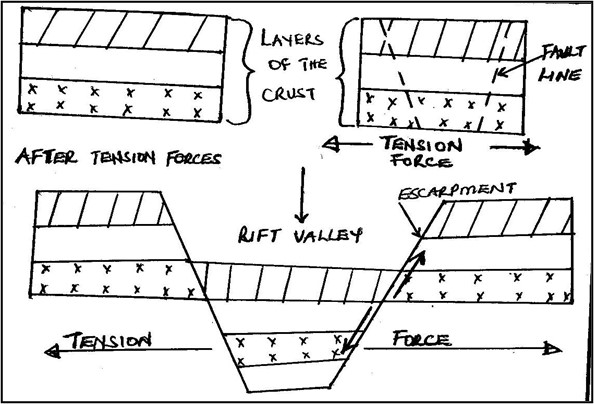
The tension force theory
According to this theory, the existence of tension forces within the crust led to stretching/pulling of rocks forming fault lines.
This later led to sinking of the middle block along the fault lines to form a trough or an elongated depression as illustrated.
Before tension forces During faulting
The compression force theory
According to this theory, the existence of compression forces within the crust acted upon/pushed the adjacent blocks forming fault lines.
The central block thrusted against the adjacent blocks forming an elongated depression/rift valley as illustrated.
Before compression forces During faulting

The differential uplift theory
According to this theory, the rift valley was formed due to vertical movement or uplift of various plates/crust along the fault lines.
During the uplift, some plates were slowly uplifted to form a rift valley while other plates were quickly uplifted to form uplands or escarpments as illustrated.

2. The block/horst mountain and its formation.
A horst is formed due to faulting process. It is an upland which is boarded by fault lines on one or more sides and which stands above the general surrounding land.
Mt. Rwenzori in Uganda is an example of a horst and it is sometimes referred to as mountains of the moon due to its high altitude. It has its peak at Margherita i.e. 5110m above sea level.
Formation of a horst
There are several theories put forward to explain the formation of Block Mountains. These include:
- The theory of relative sinking
- The theory of differential uplift
- The theory of topographical inversion.
The theory of relative sinking
This was put forward by Suess and according to him, the earth contracted and some fault blocks settled more slowly than others.
The part of the crust that sunk fast formed depressions while those which sunk slowly formed Block Mountains as illustrated.

The theory of differential uplift
According to this theory, block faulting occurred extensively which was followed by a general uplift in the faulted region.
The areas which were uplifted very fast formed block mountains while those which were slowly uplifted formed depressions as illustrated

3. Escarpments/fault scarps.
This is a steep slope where the land falls from high to low level. It is a wall of a rift valley.
Examples of escarpments in Uganda include; Kyambura and Bunyaruguru fault scarps in s. western Uganda, Butiaba scarp along and near L. Albert.
Since fault scarps are steep, they are normally destroyed by erosion and weathering agents.

4. Fault guided valley
These are formed due to displacement of rocks along a fault line. The rocks are eroded by the river to create its own valley and channel.
R. Aswa in the north and R. Manafa in the eastern are the best examples of fault guided valleys.
5. Rift valley lakes and grabens.
Grabens are formed due to secondary faulting with in a rift valley. The former rift valley is shaped to become a more defied depression know as a graben.
When grabens are filled with water, they become rift valley lakes. These lakes in Uganda include; L. Albert, L. Edward and L. George.
QN. Examine the influence of faulting on landform development in Uganda.
QN. Give an account of the tectonism process of faulting on relief and landform development in Uganda.
Approach
- Define faulting.
- Mention the three faults, and the features formed by faulting and where they are found.
- Locate the above features on the map of Uganda.
- Explain the formation of all the features mentioned above with aid of diagrams.
Economic importance of faulting in Uganda
The features of rift valley, escarpments, Block Mountain, rift valley lakes, etc formed by faulting have got the following positive and negative contributions to Uganda‘s development.
- Development of the tourist industry due to the spectacular sceneries of the western rift valley, Rwenzori horst and fault lakes like Albert. This has helped to develop infrastructure, provision of foreign exchange and jobs to Ugandans.
- The rift valley lakes of Albert, George, and Edward provide great fishing potentials were Ugandans are assured of fish proteins/food, job opportunities and incomes thus high standards of living.
- Rwenzori horst is a source of R. Mubuku, Semulik, and Nyamwamba which provide water for HEP generation like at Mubuku power station, water for irrigation at Mubuku irrigation
scheme, industrial water like for Hima Cement factory, etc. - The rift valley floor has been gazetted into national parks such as Queen Elizabeth, and this has conserved wildlife, boosted tourism for foreign exchange and provided jobs to Ugandans.
- The western rift valley floor provides suitable land for farming, settlement and infrastructural development. For example Mubuku irrigation scheme is well known for crop growing in Kasese thus reduced famine in Uganda.
- The steep slope of Rwenzori horst has favoured the growth of dense forests. Such forests have led to climatic modification i.e. heavy rains for crop growing and development of the forestry industry.
- Rift valley lakes of Albert, Edward and George provide great water transport potential. Foristance L. Albert link Uganda from Butiaba port to Muhanga port in DR Congo. This has led to flourishing trade and international relationship.
- Faulting indirectly influenced the formation of volcanic soils of Kigezi and Mt. Elgon. These soils are very fertile for crop growing like iris growing in kabala and coffee in Mbale. It has also attracted dense settlement in such areas.
- The Rwenzori horst foot hills provide a great potential for mining activities. There was mining of copper in Kilembe-Kasese and now cobalt, this earns Uganda foreign exchange, jobs to Ugandans and infrastructural development.
- Faulting indirectly led to formation of crustal warped lakes of Victoria and Kyoga which are source of fish, navigation and water for industrial use like to Uganda breweries in Luzira, water to Kampala city and for Kajjansi clay crafts.
The short comings of faulting include;
- Faulting increases the rate of earth quakes which leads to loss of property and lives. Foristance Fort Portal and kasese have been fraquently affected by earth quakes.
- Due to high altitude of Rwenzori horst, there is desertification in some parts of Kasese on the lee-ward side of the mountain. This affects crop production in the area.
- The steep escarpments of Rwenzori horst has contributed to the remoteness and inaccessibility of the area around the mountain and this limit trade.
- Faulting leads to formation of deep rift valley lakes such as Albert which restrict fishing activities and navigation. Many people lost their lives while navigating on L. Albert in 2013.
- The steep escarpments like Butiaba scarp of L. Albert and Kicwamba scarp accelerate the rate of erosion which affect crop growing and lead to siltation of water bodies.
- Rift valley soils tend to be poor in terms of crop growing since they are saline. This leads to low agriculture output.
- The rift valley floor is at a low altitude i.e. 900m above sea level like around Albert flats. This cause the area to become dry and with high temperatures.
QN. Assess the contribution of land forms of faulting to the development of Uganda
Approach
- Define faulting and mention the forces of tension and compression.
- Identify the land forms formed by faulting and where they are found.
- Locate the above on the map of Uganda.
- Examine the positive contribution and also the negative.
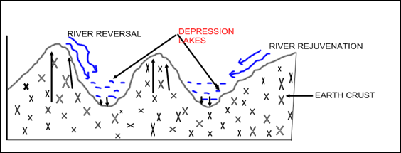
Crustal warping /Down warping and Up-warping
- The down warping and up-warping of the landscape in Uganda occurred due to an increase in the lateral compression force which affected the earth crust over a wide area.
- Down warping led to the formation of a great basin i.e. Victoria-Kyoga basin and the uplift led to the formation of uplands/plateau.
- Crustal warping also led to a general reversal in the drainage system of Uganda. Rivers such as Katonga, Kagera, Kafu, Mayanja which were originally flowing towards Atlantic Ocean reversed their water due to uplift of western Uganda to over flood the central basin. This led to formation of L. Victoria and Kyoga.
- Other rivers like Ruizi, Nzoia also reversed their flow due to uplift of the eastern Uganda. Other lakes formed include Wamala, Kachera and Kijanabarora.
Illustration of crustal warping

Folding
This is the process through which rocks of the earth’s crust are forced to bend due to lateral compression forces.
Folding process led to formation of anticlines and synclines. It also led to formation of monoclonal folds, asymmetrical folds, and simple folds and over folds.
Folding mainly affected the central, west Nile, Kigezi and Northern Uganda.
Illustration of folding
Before folding During compression forces

Vulcanicity
It refers to all the total process through which lava and other gaseous materials are either erupted into or onto the earth’s surface to form various relief features.
Vulcanicity leads to formation of two types of relief features i.e. extrusive and intrusive volcanic features.
Distribution of volcanic landforms

- Extrusive volcanicity
This is the process through which flowing lava and other gaseous materials through a vent are erupted to the earth surface, cools and solidifies to form relief features. Such features include volcanoes, calderas and caldera lakes, explosion craters and crater lakes, volcanic plugs and necks, scoria cones or ash and lava cones, lava dammed lakes and volcanic mud flows, volcanic hot springs, geysers and fumaroles.
- Volcanoes.
This is a hill or mountain which is formed when lava flows through a vent and builds around it into successive layers to form a cone-shaped feature with a crater on top.
Examples of volcanoes include Mt. Elgon, Muhavura and Moroto.
Structure of a volcano
 s
s
Volcanoes can be active, dormant, composite, or basalt dome volcanoes. It should be noted that active volcanoes are thought to have erupted recently while dormant volcanoes have not erupted.
Composite volcanoes are made up of alternating layers of ash and lava while basalt domes are large flat topped convex hills formed by basic lava with gently sloping sides like Virunga hills of south western Uganda.
- Caldera and caldera lakes
This is a large rounded depression which is formed when the upper part of a volcano is destroyed by a violent eruption.
When a caldera is filled with water it becomes a caldera lake like Napak caldera in Karamoja. Illustration;

- Explosion crater
It is a shallow flat floored depression which is surrounded by a low rim of pyroclasts (ash and lava) and rock. This is formed as a result of its vent being blown off.
When craters are filled with water it forms crater lakes like L. Katwe, Nyungu, Nyamusingira, Kyamwoga, Nyamunuka, etc in sw Uganda. Illustration;

- Volcanic plugs.
This is a cylindrical volcanic feature which is formed by lava which is so vicious and therefore forced to cool and solidify quickly within the vent. Examples include Tororo rock in eastern Uganda, a plug around L. Katwe explosion crater.
When a volcanic plug is destroyed by denudation processes such as erosion, what remains is called a volcanic neck.
- Lava plateau/lava flows.
This is upland with a generally level summit which is made up of successive layers of lava. They are formed due to basic lava
- Lava dammed lakes.
These are formed when flowing lava blocks part of the river valley, forcing it to over flood its valley like L. Bunyonyi in Kabale.
- Volcanic hot spring.
This is formed when water come into contact with heated rocks underground and they result into a spring of hot water on the earth’s surface. Examples include sempaya hot sping in Bundibugyo, Kitagata in Bushenyi, Rubaale hot spring in Ntugamo.illustration;

- Geyser.
This is formed when hot water and steam are ejected out of the earth crust periodically in a violent form.
- Intrusive volcanicity.
This is a process by which flowing magma fails to reach the earth’s surface but instead cools and solidifies within the crust to form relief features. Such features include sills, dykes, batholiths, laccolith, ring complex, etc.
- Sill.
It is formed when flowing lava flows along the bedding planes of sedimentary rocks by forcing them apart. Examples include Mubende hills in western Uganda, sukulu hills near Tororo in eastern Uganda. Illustration;

- Dyke.
This is a wall like structure which is vertically inclined rock sheet. Examples are found in Mubende hills and Sukulu hills. Illustration;

- Batholiths
This is formed when flowing lava cools and solidifies at a great depth within the crust forming a massive volcanic rock.
When batholith rocks are exposed to the surface by denudation forces of weathering and erosion, they form granitic tors or inselbergs.
Examples of batholiths include Mubende hills, Kikandwa and Kawungere batholiths in central Uganda, Singo batholiths, Laabowr ranges and Parabong ranges in Northern Uganda, Nakasongola batholiths, etc. illustration;

- Laccolith
This is a dome shapped intrusive volcanic feature with a flat topped floor. It is formed when vicious lava fails to spread out and therefore accumulates in a large mass and solidifies very quickly. Illustration;

QN To what extent has volcanicity influenced landform development in Uganda?
Approach
- Define volcanicity
- Identify the extrusive volcanic features and where they are found.
- Identify the intrusive volcanic features and where they are found.
- Locate the above on the map of Uganda
- Explain the formation of extrusive volcanic features with aid of diagrams.
- Write that; ‘however there are other processes responsible for landform development in Uganda‘
- Then explain the formation of intrusive volcanic features.
- Then explain the formation of features formed by faulting, warping, folding and denudation forces (NB. Here be brief )
The role played by Volccanicity in the Economic development of Uganda.
The features of volcanoes, crater lakes, calderas, hot springs, batholiths etc formed by volcanicity have got the following positive and negative contributions to Uganda‘s development.
- Development of the tourist industry due to the spectacular sceneries of the volcanoes like Elgon, Muhavura, hot springs of Sempaya, Kitagata, craters like Nyungu, etc. This has helped to develop infrastructure, provision of foreign exchange and jobs to Ugandans.
- Elgon volcano is a source of R. manafa, masaba, and siti which provide water for domestic use like in mbale and Sironko, water for irrigation at Doho irrigation
scheme, industrial water like for Tororo Cement factory, etc. - The fertile volcanic soils of Kigezi hills, Elgon volcano are suitable for farming, settlement and infrastructural development. For example the slopes of Mt. Elgon are well known for coffee growing thus incomes and forex to Uganda, Kigezi for food crops like vegetables, iris potatoes thus reduced famine in Uganda.
- The slope of Elgon volcano has favoured the growth of dense forests. Such forests have led to climatic modification i.e. heavy rains for crop growing and development of the forestry industry. Also Bwindi impenetrable forests on Muhavura slopes has conserved Mountain golliras and chimpanzees thus development of the tourist industry.
- There is mining of salt in L. Katwe crater, this has earned Uganda foreign exchange, jobs to Ugandans and infrastructural development.
- Hot springs and geysers like sempaya and kitagata are a potential source of geo thermal power.this can be used for home consumption reducing on deforestation for bio mass.
- The wind ward sides of Elgon volcano and kigezi highlands block moist winds for relief rainfall for crop growing. This has ensured constant food production in such areas.
Short comings of volcanism to Uganda‘s development
- Volcanic soils lose fertility quickly which affect crop growing since constant cultivation means application of fertilizers which are expensive.
- The lee-ward side of Mt. Elgon in the northern parts of the volcano are dry a disfavor to the development of agriculture.
- Rivers such as Manafa which originate from Elgon volcano do flood during rainy seasons like in 2008 it flooded its banks leading to destruction of people’s property.
- There have been landslides on the slopes of Elgon volcano like in Bududa and Bulambuli killing many people and destroying property.
- Crater lakes water like that of L. Katwe is saline less suitable for domestic use. The water is also dangerous to the people carrying out mining activities especially women.
Distribution of landforms formed as a result of Tectonism

Economic importance of tectonism in Uganda
Tectonism through its processes of faulting, volcanicity, crustal warping, earth quakes, etc, led to formation of different land forms in Uganda such as rift valley, horsts, volcanoes, craters, plateau, basins, grabens, etc.
Such features formed have got both positive and negative contributions to Uganda‘s development as discussed below.
- Volcanicity led to formation of very fertile volcanic soils like around M.t Elgon, Kigezi and Muhavura.this has flourished farming especially plantations like tea in Mubende, rice in Kibimba,food crops in Kigezi, etc.
- There is mining of salt in L. Katwe, copper and cobalt on the foot hills of Rwenzori horst, sand and clay mining from L. Victoria shores, limestone in Tororo rock thus jobs, incomes and foreign exchange to Uganda.
- Volcanoes like Mt. Elgon, Rwenzori horst and fault lakes like Albert, crustal lakes of Victoria and Kyoga, hot springs of kitagata, all provide beautiful scenery for tourism attraction. This has earned Uganda foreign exchange, jobs and international relationship for development.
- Crustal warped lakes of Victoria and Kyoga, rift valley lakes like Albert and George are potential source of fish which provide proteins, jobs to fishermen, and develops fishing industry for economy diversification.
- Lakes formed as a result of tectonism like Victoria connect Uganda to Kenya and Tanzania, L. Albert link Uganda to DR Congo, this has promoted trade and led to international relationship.
- The glaciated Rwenzori horst and Elgon volcano are source of rivers such as Mubuku and Manafa respectively. Such rivers are potential source of HEP like Mubuku power station in Kasese and water for irrigation like to Doho by R. Manafa for industrial growth and food respectively.
- The slopes of uplands formed such as Rwenzori, Elgon and Muhavura ranges, facilitates the development of a dense forest which conserve wildlife, wild birds like Mgahinga forests (Mt. golliras) on Muhavura ranges. Forests also provide wood fuel and timber especially to rural people of Kisoro and Kasese.
- The Rwenzori horst, Elgon volcano, etc modify the climate through relief rainfall formation which is heavy and reliable on the wind ward side. This facilitates flourishing farming like on the foot hills of Mt. Elgon.
- The folded highlands provide excellent grounds for population settlement. For example the folded hills of central Uganda like in Kampala have attracted settlement on Ntinda, Mengo, Rubaga and Namirembe hills.
The short comings of tectonism include;
- The uplands formed tend to be steep limiting the construction of transport networks. This tends to lead to remoteness and inaccessibility of some areas in Uganda like some parts of Kasese and in kisoro s.w Uganda.
- Volcanoes such as Elgon are prune to landslides as it was in Bududa eastern Uganda and Sironko district. This leads to property destruction and loss of life.
- The highlands formed such as Rwenzori and Moroto create a negative climatic situation of rain shadow (lee-ward effect). The absence of rain in such areas discourages crop growing and settlement in some parts of Kasese.
- Young soils formed through the volcanic process tend to be porous and easily eroded once produced like in Kisoro. Such soils are infertile limiting crop growing.
- Mountains such as Rwenzori and Elgon are source of rivers like Nyamwamba and Manafa respectively which flood leading to loss of lives and property as it was in Kasese in 2014.
QN. Examine the role played by tectonism in the economic development of Uganda.
Approach
- Define tectonism.
- Mention the processes of tectonism and identify the land forms formed by such processes and where they are found.
- Locate the features identified on a map of Uganda.
- Explain the positive and then the negative contributions of the features.
- Remember to give relevant examples.
QN. Explain the effect of tectonism on the relief and landform development in Uganda.
- Define tectonism.
- Mention the processes of tectonism and identify the land forms formed by such processes and where they are found.
- Locate the features identified on a map of Uganda.
- Explain with aid of diagrams the formation of the above features.
Denudation processes
Denudation refers to all processes through which the surface of the earth is subjected to destruction by various forces. These forces include; Glaciations, Weathering, Mass wasting and Soil erosion.
- Glaciations
This is a denudation process by which glaciers as an agent of erosion and deposition lead to formation of various features in the highland areas of Rwenzori.
A glacier is a mass of ice in motion. Some of the glaciers include valley glaciers/montane glaciers, piedmont glaciers and cirque glaciers which occupy basins on the mountain slopes.
The features formed by glaciers are both erosion and deposition, i.e.
Erosion glacial features
Erosion by glaciers takes place in two processes i.e. plucking and abrasion.
Plucking is the process by which part of the underlying rocks are frozen into the base of the ice and then pulled off.
Abrasion is the grinding process in which stones and other rock debris which are frozen into the base of a glacier are dragged over the rock floor.
Some of the erosion glacial features in Uganda include pyramidal peak or horn, arêtes or ridges, cirque or corrie, glacial trough or u-shaped valley, hanging valley, Roche montane and crag and tail.
A pyramidal peak is a steep sided feature which is surrounded by a series of radiating arêtes. It is formed by head ward erosion of cirques from all sides. In Uganda horns on Mt. Rwenzori include Margherita peak, Albert peak, Speke peak, Alexandria peak and Baker pyramidal peak.
An arête is a narrow steep sided rocky ridge that separate two cirques. It is formed by back wall recession of cirques into the mountain side. Examples on Mt. Rwenzori can be traced in Mugusu and Bujuku valley.
A cirque is a semi-circular steep sided rock basin which is cut into the valley head on mountain side by the flowing glacier. Examples on Mt. Rwenzori are Lac du Speke in Bujuku valley, Lac Catherine and Lac Noir.
A glacial trough is a broad flat bottomed steep sided valley with a roughly u-shaped cross section. It is formed due to over deepening of the original valley by an advancing strong glacier. Examples on Mt. Rwenzori include Mubuku glacial trough, Kamusoso, Bujuku and Lusilube glacial trough.
A hanging valley is an in-facing steep sided feature which is facing the glacial trough. Examples on Mt. Rwenzori are found in Bujuku, Mubuku and Mugusu Glacial troughs.
A Roche montane is a resistance rock mass which rises above the general plain. It is found on the foot hills of Mt. Rwenzori along Mubuku valley.
A crag and tail is an elongated rock mass which is formed when the flowing glaciers meet a resistant rock out crop protecting a soft rock on its lee side. This can be traced in the Rwenzori mountain Bujuku glacial trough.
The structure of some glacial erosion features on Mt. Rwenzori

Glacial deposition features.
During glacial erosion, glaciers transport their eroded materials through the following ways;
- Lateral moraine, which is materials which are transported on the sides of the glacier.
- Medial moraine, that is when two adjacent glaciers join together to form a middle moraine on top of the glacier.
- Basal moraine, this is where certain proportion of englacial moraine may reach the bottom bed of the glacier.
- Englacial moraine, this is where materials which fall into crevasses are enclosed within the glacial.
- Terminal moraine, this is materials transported using the snout which it uses to push the debris.
When a glacier transports and deposits the moraine , it leads to formation of glacial deposition features. Such features include till plains, moraines and erratic, out wash plains, eskers, kame and kame terraces and kettle holes.
A till plain is an extensive area of monotonous relief which is formed as a result of constant deposition by the glacier as its retreats.
Moraines refer to all materials carried by the flowing glacier and later deposited.
Erratic are boulders which originally were being transported by the flowing glacier and later deposited all together in a different area.
Economic importance of glaciations in Uganda
- The spectacular scenery of cirques, arêtes, and pyramidal peaks on Mt. Rwenzori attract tourists thus developing the tourist industry for foreign exchange and incomes to Ugandans.
- The glaciers are source of water for rivers such as Mubuku, Nyamwamba and Semilik. These provide water for HEP generation like at Mubuku power station, for irrigation like at Mubuku irrigation scheme, thus industrial development.
- Through the process of evaporation, glaciers modify the climate in the Rwenzori area as it leads to heavy and reliable rainfall. Such rain has helped to support coffee and food crop production in Kasese.
- The deposited moraine and within the glacial troughs of Bujuku and Mubuku on Mt. Rwenzori, there is very fertile soils which has facilitated the development of farming in the area thus food source, incomes to Bakonjo, etc.
- The glacial troughs have got relatively flatlands which have attracted population settlement and easy construction of transport networks of roads. This has made Mubuku and Bujuku areas accessible.
The short comings of glaciations include;
- Glaciers encourage the occurrence of erosion and mass-wasting along the valleys where they are flowing. This may lead to property destruction and loss of lives.
- Such rivers such as Nyamwamba and semulik tend to over flood their valleys destroying property, spreading water borne diseases, blocking roads and loss of lives as it was in Kasese in 2014.
NB. There also coastal landforms formed as a result of erosion and deposition by wave action.
Such include; caves, cliffs, cluffs, arches, stacks, beaches, lagons, sand bars, spits, etc.
Make sure you explain them.
- Weathering
This is a process through which rocks of the crust are increasingly broken down into small portions insitu.
Weathering exists into;
Chemical weathering. This is the breaking down of rocks and their decomposition which change their mineral composition.
Physical weathering. It is a process of weathering where the mineral compositions of the broken rocks do not change.
Biological weathering. This is breaking down of rocks due to the influence of living organisms such as plants and animals.
Weathering has been caused by different factors such as climate, topography, nature of the parent rock, time etc.
Weathering in Uganda has lead to formation of soil and various relief features such as inselbergs, granitic tors and exfoliation domes.
Exfoliation domes are formed as a result of fracturing of the rock surface and eventually peel-off to leave a dome. The fracturing is caused by expansion and contraction of the rock due to changes in temperature. Examples of exfoliation domes can be traced in Mubende, Nakasongola, Kitgum, Karamoja and Soroti.
Granitic tors are formed due to pressure release process. Granite rocks which contain cracks or joints are easily broken down to leave behind a dome known as granitic tor.
Examples in Uganda are found in Mubende, Kachumbala tor in Kumi, Ntungamo granitic tor, etc.
- Mass wasting.
This is the creeping, flowing, falling and sliding of rock debris and other weathered materials down slope under the influence of gravity.
Landslides, is the abrupt falling of rock debris down the slope mainy caused by heavy rains. Landslides are mainly experienced in Elgon slopes in Bududa and in Muhavura ranges.
Factors which influence landslides and mass wasting
- The nature of relief of an area, steep slopes like in Bundibugyo accelerates the rate of landslides and gently sloping areas slows down the rate of mass wasting.
- Deforestation, lumbering and other human activities which clear vegetation on steep slopes accelerates the rate of landslides as it has been in Bududa eastern Uganda.
- Road construction across steep slopes, settlements and farming on steep slopes like in Kisoro s.w Uganda has accelerated the rate of mass wasting.
- The occurrence of tectonism forces of volcanicity, faulting and earth quakes in Fort Portal western Uganda, disturbs the rock structure thus mass wasting.
- Heavy rain fall received in steep sloping areas which deeply saturate the rock debris in the region causing it to fall down wards due to its heavy weight like how it was in Sironko and Bududa in eastern Uganda.
- Highly weathered rocks on steep slopes are easily slided down compared to un-weathered rocks.
- Mining and quarrying which creates steep scarps which later accelerate sliding like in Ntugamo.
Negative effect of landslides
- It leads to loss of lives and property destruction where it has occurred e.g. in Bududa at foot hills of Mt. Elgon.
- It leads to loss of agricultural land since the falling rock debris may cover up the fertile soils.
- There is destruction of important infrastructure such as blocking of roads and railway lines network like in Bundibugyo and Kisoro districts in Uganda.this makes these areas remote and inaccessible.
- Landslides in an area can facilitate flooding in an area which cause water borne diseases such as bilhazia.
Ways of controlling landslides
- Tree planting and reforestating areas on steep slopes damaged by deforestation.
- Educating local people about the dangers of poor practices of farming on steep slopes, deforestation, cultivation and settlement on the steep slopes which cause landslides.
- Introducing and emphasizing the use of better methods of farming like terracing, strip cropping and contour ploughing on steep slopes.
- Filling pits where mining and quarrying have been carried out.
- Strict laws can be formulated to protect steep slopes from being settled, cultivated, etc.
- Soil erosion
This is the process where the top layer of soil is removed by the agents of erosion i.e. running water, wind and animals.
The areas affected by erosion in Uganda include Kigezi highland of south western Uganda, Karamoja region in north eastern Uganda, Elgon slopes in eastern Uganda, Ankole Masaka Corridor and Kasese region in south western Uganda.
Major areas affected by erosion in Uganda

Causes of soil erosion in Uganda

- The nature of climate in an area like Karamoja area in north eastern Uganda which is dry throughout the year. This gives chance to blowing winds to erode the soil.
- When people settle on a steep relief, they clear the vegetation encouraging running water to carry soils down the slope. This is experienced in Kigezi region mainly Kabale and Kisoro.
- Overstocking which results into overgrazing like in Karamoja region. This clears the vegetation leaving bare land which is easily carried by either wind or running water.
- Rapid population growth rate which results in land fragmentation and continuous clearing of vegetation on steep slopes like as in Kigezi south western Uganda. This accelerates running water erosin.
- Use of poor farming methods such as monoculture, communal grazing which leads to overgrazing like in Karamoja and some parts of Ankole Masaka corridor thus accelerating soil erosion.
- Heavy rain fall received in an area especially on steep slopes which have been deforestated, this cause running water to carry down soil like in Elgon slopes eastern Uganda.
- Volcanic soils when repeatedly cultivated like in Kigezi south western Uganda, they lose their fertility and therefore easily carried down slope by running water.
- Ignorance of the local people about the control measures of erosion. Such people continuously deforestate and over cultivate on steep slopes like as in Kasese on foothills of Rwenzori which encourages soil erosion.
- Practices of polygamy and land inheritance have led to increased land fragmentation, deforestation and vegetation deletion as in Kigezi south western Uganda thus automatic soil erosion.
- Burning bush especially by nomads during dry seasons so as to regenerate paratable pasture for their animals. This in turn leads to erosion.
Effects of soil erosion in Uganda
- Soil erosion leads to siltation of river valleys which result into floods like in R. Manafa from Elgon slopes. Floods block roads, cause water borne diseases like bilharzias and destroy property.
- Since the top soil which contains nutrients are eroded, there is loss of fertile soils thereby reducing its productivity.
- The low productivity of soil may lead to famine and food shortage in such areas like Kigezi south western Uganda.
- Due to unproductive soils, crop growing is discouraged and this leads to unemployment and general poverty.
- The effect of soil erosion on agriculture i.e. reduced productivity, affects the export sector of Uganda since the country dominantly exports agricultural products.
- Soil erosion leads to large scale population migration from the affected area that is why KIgezi in south western Uganda has remained the source of population migration to various parts of Uganda.
- Soil erosion increases on the rate of government expenditure to provide social services for the affected groups like in Karamoja.
Ways to control soil erosion.
- Family planning programs should be extended to affected areas so as to control rapid population growth rate which results into land fragmentation.
- The nomads should be encouraged to practice modern and scientific methods of farming such as paddocking and controlled grazing, individual land ownership, afforestation, etc.
- The masses should be taught how to practice better and modern farming methods of terracing, contour ploughing and strip cropping. Monoculture should be discouraged.
- Highly populated areas of Kigezi in south western Uganda should be encouraged to carryout migrations to sparsely populated areas so as to control fragmentation.
- People should be encouraged to practice agro-forestry especially in steep sloping areas of Kasese to check on running water effect.
- Settlement along steep slopes should be discouraged and people in such areas of Mubuku and Bujuku on steep slopes of Rwenzori be encouraged to practice aforestation, re-forestation, and filling up gullies created by erosion.
QN. Account for soil erosion in Uganda
Approach
Define soil erosion
Identify the types of erosion
State the areas affected by erosion in Uganda
Locate the above on a map of Uganda
Explain the physical and human causes of erosion giving examples in each.