WEEK FOUR AND FIVE
TOPIC: SURVEYING AND PLANNING OF FARM STEAD
CONTENT
- MEANING
- IMPORTANCE
- COMMON SURVEYING EQUIPMENT
MEANING OF FARM SURVEYING
Farm surveying is defined as the process of measuring and mapping out the position, topography, size and boundary of an area of farm land. It can also be defined as the process by which measuring of land is made on the farm.
IMPORTANCE OF FARM SURVEYING
- It helps to determine the farm land.
- It is useful for the preparation of feasibility studies.
- It ensures proper use of the farm land.
- It helps in proper location of the farm building.
- Farm maps or soil maps are useful in planning the farm stead.
- The results of farm survey are used for soil classification.
- It can be used to make projection of future yield.
- It can be used as collateral for loan.
- It can be useful for the acquisition of C of O.
- It can be used to determine the gradient of the farmland.
EVALUATION
- What is farm surveying?
- List five importance of farm surveying.
SOME COMMON SURVEYING EQUIPMENT AND THEIR USES
- RANGING POLE
DESCRIPTION
- It is made up of wood or metal.
- It is of varying length e.g 1.8, 2.4, 3m.
- It is usually painted black, bright red and white to enable it to be seen from distance.
- It has a pointed end.
FUNCTIONS
- It is useful for making stations.
- It is also used for making a straight line.
- GUNTER’S CHAIN
DESCRIPTION
- It consists of a series of dumb bell shaped links of steel wire joined together by three small rings.
- The length is normally 20.13m (66ft).
- The chain is entirely metallic.
FUNCTION
It is used to take short detailed measurement of length and breadth.PRECAUTIONS WHEN CHAINING THE FARM LAND
- Pull tant chains, tapes or ropes.
- Avoid errors of transporting figure on papers.
- All chains, tapes, ropes e.t.c must be properly aligned before taking measurement.
- Avoid errors of parallax when reading measurements.
- Make sure the chain is not faulty before use.
- MEASURING TAPE
DESCRIPTION
- It is usually made of line or fine steel sheet.
- It is marked on one side with metric units and the other side with the impanel unit.
- The tape is normally wound in a small ease from where it is unwound for use.
FUNCTION
It is used for taking measurement of length breadth and height. - PRISMATIC COMPASS
DESCRIPTION
- It is normally placed on a stand.
- It has a prism.
- It has a compass card marked in degrees, half degrees, minutes and seconds, in a clockwise direction.
- It has a straight slot.
FUNCTION
It is used in taking bearings. It is also used in measurement of angular, distances. - THEODOLITE
DESCRIPTION
- It consists of tripod stand, made of wood or lightweight metal in solid or telescope legs.
- The tripod stand forms the base of the instruments.
- It has a lower plate which contains the graduated horizontal circle made of glass or brass.
- It has a spirit level which is used to define horizontal plain against, which angles of elevation or depression are measures.
FUNCTION
It is used to measure horizontal or vertical angles or planes. - ARROW OR PIN
DESCRIPTION
- This is a thin pointed steel wires of about 30cm long with one end curved into a ring.
- A red cloth is normally attached to the ring so that it can be seen from afar.
FUNTION
- It is used during chaining for marking off chain length as measured.
- It can also be used for making stations.
- OFFSET STAFF
DESCRIPTION
- This is graduated rod 3m long.
- A hook may be fitted at the top for the purpose of pulling a chain through a hedge.
- Each telescopic link is 0.3m (30cm) in length.
FUNCTION
It is used for taking short offset measurement. - BEACON OR PILLAR
DESCRIPTION
- It is made of rectangular block usually in concrete form.
- Marks are usually inscribed on top of the block.
- The beacons are always buned in the ground with the marked head raised a little above ground.
FUNCTION
- It is used for marking point off measured.
- It is also used for recognition of the measured or surveyed area.
GENERAL MAINTENANCE OF SURVEYING
- All instruments must be cleaned after use.
- Keep instruments in dry and cool place.
- Metal parts should be oiled, greased or painted before storage.
- Keep them away from rain and heat to prevent rusting.
- Replace worn out parts.
- Use the instruments only for the intended functions.
- Let competent surveyor handle and use the instruments only.
EVALUATION
- List seven surveying instruments and state their uses.
- List five general maintenance of surveying instruments.
MEANING AND IMPORTANCE OF FARMING PLANNING
Farm planning is a drawing or outline of a farm stead in order to put the land into use for which is best suited.IMPORTANCE OF FARM PLANNING
- It enables farmer to make proper use of land.
- It ensures proper siting of certain buildings or structures in certain locations within farm stead.
- It ensures the location of livestock building in relation to other farm building.
- It promotes neatness and prevents pollution within farm stead.
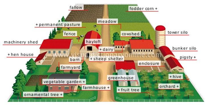
FARM STEAD
Farm stead can be defined as a farm house and all its production and processing structures.
Farm stead is both a home and a production center.FACTORS INFLUCING THE SITING OF FARMS OR FARM STEAD
These factors include: - Topography
- Soil type
- Accessibility
- Water supply
- Health /Hygiene
- Nearest to market
- Drainage

REASONS FOR PLANNING FARMSTEAD
- It allows for proper utilization of resources without wastage.
- It makes farmer to be more responsive to market demand.
- It encourages the efficiency of farm activities.
- It makes coordination and control of farm operation easier.
PRINCIPLE OF FARMSTEAD LAYOUT
- Plant crops on the best soil within the farm.
- Livestock building should be located in the poorest soil within the farm.
- Buildings should be located in easily accessible areas.
- Farm buildings should not be located on slope to avoid erosion.
- Residential and office buildings should be located far away from livestock building to avoid noise and unpleasant smells.
EVALUATION
- What is farm planning?
- List five factors influencing the siting of farmstead or farm.
CALCULATIONS OF AREA OF FARMLAND AND PLANT POPULATION
- Area of farmland: This is the area of shape of the farm e.g. LXB for rectangular, ½ bh for triangle.
- Number of plant stand /plant population: This is the number of plants in an area of farm land.
Mathematically:
Plant population = - Spacing: This is the distance between one crop plant and the next plant e.g. 60cm by 30cm.
Note that one hectare = 100,000m2
Example:
If the length and width of a farmland are 60m x 30m.
Calculate
(a) the area of the farmland
(b) the plant population (tomatoes) in the given area
(c) the total population if there are two plants per stand
Solution - Area of the farmland
= Length x Width
= 60m x 30m
= 1800m2 - Spacing of crop = 30cm x 30cm
Or 0.3m x 0.3m
Area of 1 stand of crop = 0.3m x 0.3m
= 0.09m2
No of stand/crop =
=
= 20,000crops stands
The plant population of tomatoes is 20,000 stands - Since there are two plant population
= 20,000 x 2
= 40,000 tomatoes plantsGENERAL EVALUATION
- What farm survey?
- List five surveying equipment and state their uses.
- What is farmstead?
- List five factors influencing the siting of farmstead.
- List five factors coupled implements.
READING ASIGNMENT
Essential Agricultural Science for Senior Secondary Schools by O.A. Iwena, Chapter 22, pages 214 – 222WEEKEND ASSIGNMENT
- The surveying equipment used for taking bearings and angular distances is _____
(a) tape (b) ranging pole (c) offset staff (d) prismatic compass
- The instrument used for measuring horizontal and vertical angles for planes id _____ (a) theodolite (b) pins (c) beacon (d) tape
- Which of these is not a factor influencing the siting of farmstead (a) topography
(b) soil type (c) accessibility (d) weather
- One hectare is ____ square meters (a) 1000 (b) 10,000 (c) 100,000 (d) 1 million
- ½ (A+B)H is the area of ____ (a) triangle (b) square (c) trapezium (d) rhombus
SECTION B
- (a) What is farm surveying?
(b) List four surveying equipment and state their uses.
- (a) Define a farmstead.
(b) Enumerate the importance of farm surveying and planning in agriculture.