Share this:
Specific Objectives
By the end of the topic the learner should be able to:
- Interpret a given scale
- Choose and use an appropriate scale
- Draw suitable sketches from given information
- State the bearing of one point from another
- Locate a point using bearing and distance
- Determine angles of elevation and depression
- Solve problems involving bearings elevations and scale drawing
- Apply scale drawing in simple surveying.
Content
- Types of scales
- Choice of scales
- Sketching from given information and scale drawing
- Bearings
- Bearings, distance and locating points
- Angles of elevation and depression
- Problems involving bearings, scale drawing, angles of elevation and depression
- Simple surveying techniques.
Introduction
The scale
The ratio of the distance on a map to the actual distance on the ground is called the scale of the map. The ratio can be in statement form e.g. 50 cm represents 50,000 cm or as a representative fraction (R.F), 1: 5,000,000 is written as.
Example
The scale of a map is given in a statement as 1 cm represents 4 km. convert this to a representative fraction (R.F).
Solution
One cm represents 4 x 100,000 cm. 1 cm represents 400, 000
Therefore, the ratio is 1: 400,000 and the R.F is
Example
The scale of a map is given as 1:250,000.Write this as a statement.
Solution
1:250,000 means 1 cm on the map represents 250,000 cm on the ground. Therefore, 1 cm represents
I.e. 1 cm represents 2.5 km.
Scale Diagram
When during using scale, one should be careful in choosing the right scale, so that the drawing fits on the paper without much details being left.
Bearing and Distances
Direction is always found using a compass point.
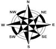
A compass has eight points as show above. The four main points of the compass are North, South, East, and West. The other points are secondary points and they include North East (NE), South East (SE), South West (SW) and North West (NW).Each angle formed at the centre of the compass is the angle between N and E is.
Compass Bearing
When the direction of a place from another is given in degrees and in terms of four main points of a compass. E.g. N, then the direction is said to be given in compass bearing. Compass bearing is measured either clockwise or anticlockwise from North or south and the angle is acute.
True bearing
North East direction, written as can be given in three figures as measured clockwise from True North. This three– figure bearing is called the true bearing.
The true bearings due north is given as.Due south East as and due North West as.
Example
From town P, a town Q is 60km away on a bearing South 80º east. A third town R is 100km from P on the bearing South 40º west. A cyclist travelling at 20km/h leaves P for Q. He stays at Q for one hour and then continues to R. He stays at R for 1½ hrs. and then returns directly to P.
(a) Calculate the distance of Q from R.

P² = 100² + 60² – 2(100) (60) Cos 120
P² = 13600 – 12000 Cos 120
P² = 19600
P = 140km
(b) Calculate the bearing of R from Q.
![]() M1
M1
![]() M1
M1
= 38.2° A1
Bearing 270 – 38.2 = 241.8 B1
(c) What is the time taken for the whole round trip?
 Time from P to R
 ![]()
Time from Q to R ![]()
From R to P ![]()
Taken travelling = 3 + 7 + 5 M1 P
= 15hrs
Example
A port B is on a bearing 080o from a port A and a distance of 95 km. A Submarine is stationed at a port D, which is on a bearing of 200o from A, and a distance of 124 km from B. A ship leaves B and moves directly Southwards to an Island P, which is on a bearing of 140o from A. The Submarine at D on realizing that the ship was heading to the Island P, decides to head straight for the Island to intercept the ship. Using a scale of 1 cm to represent 10 km, make a scale drawing showing the relative positions of A, B, D and P. {4 marks}
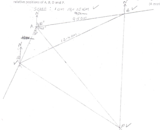
Hence find:
b) The distance from A to D. {2 marks}
c) The bearing o the Submarine from the ship when the ship was setting off from B. {1 mark}
d) The bearing of the Island P from D. {1 mark}
e) The distance the Submarine had to cover to reach the Island P {2 marks}
Angle of Elevation and Depression
 Angle of Elevation:
The angle above the horizontal that an observer must look to see an object that is higher than the observer. Example, a man looking at a bird.
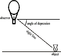 Angle of Depression:
The angle below horizontal that an observer must look to see an object that is lower than the observer. Example, a bird looking down at a bug.
Angles of depression and elevation can be measured using an instrument called clinometer
To find the heights or the lengths we can use scale drawing.
Simple survey methods
This involves taking field measurements of the area so that a map of the area can be drawn to scale. Pieces of land are usually surveyed in order to:
- Fix boundaries
- For town planning
- Road construction
- Water supplies
- Mineral development
Areas of irregular shapes
Areas of irregular shape can be found by subdividing them into convenient geometrical shapes e.g. triangles, rectangles or trapezia.
Example
The area in hectares of the field can be found by the help of a base line and offsets as shown.
Fig 22.26
XY is the base line 360 m.SM,RP and QN are the offsets.
Taking X as the starting point of the survey,the information can be entred in a field book as follows.
The sketch is as follows:
Using a suitable scale.
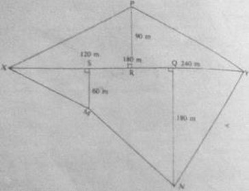
The area of the separate parts is found then combined.
Area of:
Triangle XPR is ½ x180 x 90 = 8100
Triangle PRY is ½ x180 x 90 = 8100
Triangle XSM is ½ x120 x 60 = 3600
Triangle QNY is ½ x120 x 180 = 10800
Trapezium SQNM = ½(QN + SM) x SQ
½ (180 + 60) x 120
= 14400
Total area = 8100 + 8100 + 3600 + 10800 + 14400 = 45000
End of topic
Did you understand everything? If not ask a teacher, friends or anybody and make sure you understand before going to sleep! |
Past KCSE Questions on the topic
- A point B is on a bearing of 0800 from a port A and at a distance of 95 km. A submarine is stationed at a port D, which is on a bearing of 2000 from AM and a distance of 124 km from B.
A ship leaves B and moves directly southwards to an island P, which is on a bearing of 140 from A. The submarine at D on realizing that the ship was heading fro the island P, decides to head straight for the island to intercept the ship
Using a scale 0f 1 cm to represent 10 km, make a scale drawing showing the relative positions of A, B, D, P.
Hence find
(i) The distance from A to D
(ii) The bearing of the submarine from the ship was setting off from B
(iii) The bearing of the island P from D
(iv) The distance the submarine had to cover to reach the island P
- Four towns R, T, K and G are such that T is 84 km directly to the north R, and K is on a bearing of 2950 from R at a distance of 60 km. G is on a bearing of 3400 from K and a distance of 30 km. Using a scale of 1 cm to represent 10 km, make an accurate scale drawing to show the relative positions of the town.
Find
- The distance and the bearing of T from K
- The distance and the bearing G from T
- The bearing of R from G
3. Two aeroplanes, S and T leave airports A at the same time. S flies on a bearing of 060 at 750 km/h while T flies on a bearing of 2100 at 900km/h.
(a) Using a suitable scale, draw a diagram to show the positions of the aeroplane after two hours.
(b) Use your diagram to determine
(i) The actual distance between the two aeroplanes
(ii) The bearing of T from S
(iii) The bearing of S from T
4. A point A is directly below a window. Another point B is 15 m from A and at the same horizontal level. From B angle of elevation of the top of the bottom of the window is 300 and the angle of elevation of the top of the window is 350. Calculate the vertical distance.
- From A to the bottom of the window
- From the bottom to top of the window
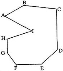
- Find by calculation the sum of all the interior angles in the figure ABCDEFGHI below

6. Shopping centers X, Y and Z are such that Y is 12 km south of X and Z is 15 km from X. Z is on a bearing of 3300 from Y. Find the bearing of Z from X.
7. An electric pylon is 30m high. A point S on the top of the pylon is vertically above another point R on the ground. Points A and B are on the same horizontal ground as R. Point A due south of the pylon and the angle of elevation of S from A is 260. Point B is due west of the pylon and the angle of elevation of S from B is 320
Find the
(a) Distance from A and B
(b) Bearing of B from A
8. The figure below is a polygon in which AB = CD = FA = 12cm BC = EF = 4cm
and BAF =- CDE = 1200. AD is a line of symmetry.
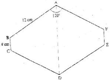
Find the area of the polygon.
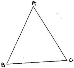
9. The figure below shows a triangle ABC
a) Using a ruler and a pair of compasses, determine a point D on the line BC
such that BD:DC = 1:2.
b) Find the area of triangle ABD, given that AB = AC.
10. A boat at point x is 200 m to the south of point Y. The boat sails X to another
point Z. Point Z is 200m on a bearing of 3100 from X, Y and Z are on the same horizontal plane.
- Calculate the bearing and the distance of Z from Y
- W is the point on the path of the boat nearest to Y.
Calculate the distance WY
- A vertical tower stands at point Y. The angle of point X from the top of the tower is 60 calculate the angle of elevation of the top of the tower from W.
11. The figure below shows a quadrilateral ABCD in which AB = 8 cm, DC = 12 cm, Ð BAD = 450, Ð CBD = 900 and BCD = 300.

Find:
- The length of BD
- The size of the angle A D B
 12. In the figure below, ABCDE is a regular pentagon and ABF is an equilateral triangle
Find the size of
- Ð ADE
- Ð AEF
- Ð DAF
13. In this question use a pair of compasses and a ruler only
- construct triangle ABC such that AB = 6 cm, BC = 8cm and ÐABC 1350
(2 marks)
- Construct the height of triangle ABC in a) above taking BC as the base
(1 mark)
14. The size of an interior angle of a regular polygon is 3x0 while its exterior angle is (x- 20)0. Find the number of sides of the polygon
15. Points L and M are equidistant from another point K. The bearing of L from K is 3300. The bearing of M from K is 2200.
Calculate the bearing of M from L
16. Four points B,C,Q and D lie on the same plane point B is the 42 km due south- west of town Q. Point C is 50 km on a bearing of 5600 from Q. Point D is equidistant from B, Q and C.
(a) Using the scale 1 cm represents 10 km, construct a diagram showing the position of B, C, Q and D
(b) Determine the
(i) Distance between B and C
(ii) Bearing D from B
17. Two aeroplanes P and Q, leave an airport at the same time flies on a bearing of 2400 at 900km/hr while Q flies due East at 750 km/hr
(a) Using a scale of 1v cm drawing to show the positions of the aeroplanes after 40 minutes.
(b) Use the scale drawing to find the distance between the two aeroplane after 40 minutes
(c) Determine the bearing of
(i) P from Q ans 2540
(ii) Q from P ans 740
18. A port B is no a bearing of 080 from a port A and at a distance of 95 km. A submarine is stationed port D which is on a bearing of 2000 from A, and a distance of 124 km from B.
A ship leaves B and moves directly southwards to an island P, which is on a bearing of 1400 from A. The submarine at D on realizing that the ship was heading for the island P decides to head straight for the island to intercept the ship.
Using a scale of 1 cm to represent 10 km, make a scale drawing showing the relative position of A, B D and P.
Hence find:
(i) The distance from A and D
(ii) The bearing of the submarine from the ship when the ship was setting off from B
(iii) The baring of the island P from D
(iv) The distance the submarine had to cover to reach the island
19. Four towns R, T, K and G are such that T is 84 km directly to the north R and K is on a bearing of 2950 from R at a distance of 60 km. G is on a bearing of 3400 from K and a distance of 30 km. Using a scale of 1 cm to represent 10 km, make an acute scale drawing to show the relative positions of the towns.
Find
(a) The distance and bearing of T from K
(b) The bearing of R from G
20. In the figure below, ABCDE is a regular pentagon and M is the midpoint of AB. DM intersects EB at N. (T7)

Find the size of
(a) Ð BAE
(b) Ð BED
(c) Ð BNM
21. Use a ruler and compasses in this question. Draw a parallelogram ABCD in which AB = 8cm, BC = 6 cm and BAD = 75. By construction, determine the perpendicular distance between AB and CD.
22. The interior angles of the hexagon are 2x0, ½ x0, x + 400, 1100, 1300 and 1600. Find the value of the smallest angle.
23. The size of an interior angle of a regular polygon is 1560. Find the number of sides of the polygon.