
Share this:
1.4 OCEANS AND SEAS
OCEAN:
OCEAN:
– -The body of salt water which cover 70.78% of the earth surface.
– -Is the very wide area on the land surface covered with water. This part of the land should be cover millions of kilometres of water.
SEAS:
– -As applied to the great body of salt water and earth surface (ocean) as opposed to land
OR
– -Are the smaller bodies of salt water of the ocean
OR
-A large body of in land salt water for example the sea of Aral.
OR
– -Is the wide part of land surface covered with water. The sea is intermediate between the ocean and lake in their wideness with salt water E.g. red sea.
- The ocean and sea are interlinking with mineral composition the major mineral composed within the sea / ocean are magnesium , calcium ,sodium and other mineral the dominant mineral is the salt.
OCEANOGRAPHY
– -Is the study of ocean with main interest on the properties of ocean water and its motion
– -It is also deal with the chemical reaction lives (biodiversity) and the structure of the ocean bed including the process that are active in the ocean.
– -The ocean regulate in number of major process that operate on the earth`s surface.
– -They are primary source of the water that reaches the continent as rain and snow.
– -Contain the largest reserves of carbon which is essential to the biological cycle
– -Contain / has a high heat capacity that make it an important regulation of climate (ability to absorb greater quantity of heat )
– -The movement of water in the ocean (ocean current) is important for both marine and life and human for navigation for many years. That is for transport and communication (wires pass under water )
STRUCTURE OF OCEANS:
– -Topography -Ocean floor.
Depth of the oceans – About 4,000m (average depth)
Depth of seas – Is about 1,200m
-In relation to the sea level the ocean are much deeper than the land is high. (Height in depth of ocean is high compare to the land)
– Surface of the earth is only 11%of the land is more than 2000m above the sea level while 84% of the sea bottom is more than 2000m deep.
– The highest elevation that is mountain Everest on the land is 8840m the Marianas Trench in the west Pacific Ocean is 11,000m.
There are 3 major areas in the ocean;
i) Continental margins
ii) Deep ocean basins
iii) Mid oceanic ridges
i) CONTINENTAL MARGINS – It comprises the continental shelf, continental slope and continental rise.
It is divided into;
a) a) The shore
b) b) The continental shelf
c) c) The continental slope
d) d) The continental rise.
a) Continental shelf
– -Extension of the continental into the ocean. / Widest around the shores of lowland areas.
– -Is a gentle slope submerged surface extending from the shores line towards the deep ocean base
– -It is underlined by continental types crust and therefore it is a Clearly flooded extension of the continent
– -There is great variation in width and almost non – existed alongside continental and on the average it is about 80km and 130m deep at the sea ward edge.
– -The average inclination of the continental shelf is lesser than  of1 degree a drop of only about 2m per km the slope is so slight that it would appear the observer to be a horizontal surface.
– -It is not completely smooth due to presence of extensive glacial deposits in some places and therefore it is rugged/rough.
Prominate features – Include long valley of many rivers running from the coastline cross the continental shelf into the deep sea water
-Example; Western Europe and north – Eastern North America
b) Continental slope – This area is characterized by a steep gradient compare to the continental shelf
-Marks the boundary between the continental crust and oceanic crust.
-The average inclination of the continental slope is about 5o and in some place may exceed 25o. The average depth vertically from the shelf to the deep sea bottom is on average 4000m.and in some place extend to as much as 9000m vertical over a relatively short horizontal distance.
-Along mountainous coast the continent slope descend abruptly into deep ocean trenches located between the continent and the ocean basin in such a case the shelf is very narrow or non- existence.
ii. DEEP OCEANIC BASINS
The deep ocean basins which are about 2.5 to 3.5miles deep, covers 30% of earth’s surface and has feature such as abyssal plains, deep sea trenches and sea mounts (70% of entire ocean area
· The abyssal plain – Is the flat deep ocean floor. It is almost featureless because thick layers of sediment cover the hills and valleys of the ocean floor below it.
· Deep sea trenches – Are the deepest part of the ocean the deepest one the Marianas Trench in the South Pacific Ocean is more than 35,000 feet (11,000m) deep.
iii. MID OCEAN-RIDGE
-The mid ocean ridge is two chain of mountains separated by a large depression (or rift valley) that form a spreading center (or where two plates are drifting apart). The mountain ranges can have peaks as high as 12,000ft (2500m) and some even reach above the ocean surface.
– -Ice land along the mid – Atlantic ridge is an example.
– -In the rift valley which can be 15 – 30miles (24 to 48kmwide, new ocean crust is being made which means a lot of seismic activity is happening.
– -Sea Mountain began life as volcanic formed over hot spot in the ocean floor. After the crust moves off the hot spot the volcanic activity stops.
– -Sea Mountain is usually 25miles (40km) in diameter and can be 3000 – 4500m tall. Some are so tall that their peaks pierce the ocean surface forming a volcanic island.
LIST OF SOME OCEAN AND SEAS FOUND IN THE WORLD:
NAME | AREAS (square meter) | AVERAGE depth (m) |
PACIFIC OCEAN | 60,060,700 | 4,028 |
ATLANTIC OCEAN | 29,637,900 | 3,926 |
INDIAN OCEAN | 26,469,500 | 3963 |
SOUTHERN OCEAN | 7,848,300 | 4,000 – 5,000 |
ARCTIC OCEAN | 5,427,000 | 1,205 |
MEDITERRANEAN SEA | 1,114, 800 | 1429 |
CARIBBEAN SEA | 1,049,500 | 2647 |
SOUTH CHINA SEA | 895,400 | 1652 |
SALINITY IN THE OCEANS:
– -Salinity is the amount of salt concentration within the sea/ocean. Salinity means the rate/ amount of salt.
– -Most of the salt in the ocean come from land. Over millions of years, Rain, River and streams have washed over rocks containing the compound sodium chloride (Nacl) and carried into the sea.
– -Actual mineral content of river water differ materials from that of the sea.
– -River water contains much of calcium salts (calcium carbonate) than sodium salt.
– -The average salinity is said to be 35% for the whole ocean
– -Sodium chloride (78%) most important salt in the sea water.
Distribution of salinity
– -Rainfall, evaporation, river run off and ice formation (melting) cause the variation of salinity in the ocean where by the average of salinity varies between 32 and 37%.
– -Areas of highest salinity lie near the tropic (about 37%) where skies are clear constant high temperature and brisk trade winds maintain active evaporation.
– -Salinity decrease towards the equator (equatorial) 35% where rainfall is heavier and evaporation less because of the higher relative humidity, greater cloudiness of calmer air masses of the doldrums.
-There is also a decrease towards the poles (less than 34%), the result of melting ice and decreasing evaporation.
FACTOR AFFECTING THE RATE OF SALINITY WITHIN THE SEA
i. Climatic condition :
During winter season, rain formation, addition of water within the sea reduce the amount of salt while during summer there is high rate of temperature, high effective evaporation of water influence large concentration of salt.
ii. Ocean current:
Is the surface running water within the sea. They are moving in specific channel within the sea.
Types of ocean current.
– Warm ocean current.
Is the surface running water within the sea. They are moving in specific channel within the sea.
Types of ocean current.
– Warm ocean current.
High rate of temperature influence high evaporation and large concentration of salt.
– Cold ocean current.
Low rate of temperature, poor evaporation and low rate of salt.
iii. Amount of river stream within the sea.
Presences of river entering the sea reduce the amount of salt and absence increase concentration of salt.
iv. Wind action.
Strong winds affect the concentration of water and salt.
v. Wideness of the sea.
Wide sea leads to large concentration of salt since cannot/difficult to be affected by variation situation.
vi. Amount of vegetation cover.
Presence of mangrove trees which use a lot of salt reaches the amount of salt in the ocean.
OCEAN WATER TEMPERATURE
-The water of the ocean has considerable degree of heat known as sea temperature the temperature is created as oceans warmed by heat radiated from the sun. However the surface water warmed more slowly than the land, and looses heat to air also more slowly.
-Temperature of the sea water varies considerably from region to regions, time to times and depth to depths due to some determinant factors and includes the following
1. Latitudinal position of an area
-Amount of solar radiant energy, differs from region to regions. Usually all tropical area experience higher insulation than the Polar Regions as heat radiated from the some received at right angle. Hence the temperature of the ocean in equatorial region is higher at about 26 and gets progressively low towards the poles.
Latitude (North and South) | Average temperature |
Equatorial region 20° 40° 60° Polar region | 20°C 23°C 14°C 1°C |
2. Local cloud covers
-The clouds tend to absorb the heat radiated from the sun to the water surface, It is thus, if clouds make intensive coverage lower the sea temperature.
3. The sun’s altitude from the water surface
-If the sun’s altitude is greater enough to the earth’s surface more heat from the sun is scattered and absorbed on the way before reaching the earth surface at which absorbed. It is thus: the marine water in tropical regions is warm as the sun’s altitude is small to the surface compared to polar seas like that of Arctic seas.
4. Distance of the earth from the sun
-When the earth is at farthest position from the sun, less heat received by the earth surface and makes low sea temperature, Conversely, when the sun is at nearest position, more heat received and makes high sea temperature is much based on the sun over head. In the same geographical region. The sea temperature can vary time to time depending on the prevailing season whether or winter.
5. Ocean currents
-Warm ocean currents maintain steadily higher temperature by warm water brought into the area. Cold ocean currents lower sea temperature.
6. Atmospheric absorption an scattering
-If more heat from the sun scattered and absorbed in the atmosphere, make low sea temperature as less heat reach the surface and absorbed. Conversely, if less heat scattered and absorbed sea temperatures become high as more heat reach the surface.
MOVEMENT OF OCEAN WATER
-Surface water in the ocean basin is not stationary. It moves differently and thus recognized to have varied forms of movement. There are three forms of ocean surface water movement and include the following.
· i.Waves
· ii.Tides
· iii. Ocean currents
Note:
– Waves and tides make vertical movement of oceanic water.
– Ocean currents make horizontal of oceanic water.
I.WAVES
Waves refer to upward and down ward movements of sea water. Waves are produced by the following causal factors.
· -Transfer of energy by the wind blowing over surface of the sea.
· -Earth quakes refers to the occurrence of sudden uplift of the
oceanic bed.
oceanic bed.
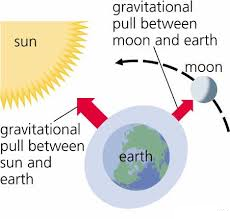
· -Gravitational attraction of the moon and sun. The waves tend to occur as water rise to high tide level.
The structure of the wave
-The structure of a wave is by its contrasting parts.
· -The upward part of the wave s called crest or anticline.
· -The lower part of the wave is called trough or syncline.
· -The horizontal distance from a crest to another successive crest is called wave light. The vertical distance between the crest and trough is called

-Waves make movement towards the coast and back away from the coast. The forward movement of a wave to the coast is called swash, and the back ward movement is called backwash. Hence swash is the water approaching the coast from the sea; while backwash is the water returning from the coast
Classification of waves
-Waves are classified according to causal factors and their nature of effects along the coast.
According to causal factor waves are classified into the following types
(a) Seismic waves; these are the larger waves generated by the force of wind blow.
(b Seismic waves; These are the large waves generated by the oceanic bottom (sima) usually caused by earth quakes, They are alternatively called tsunamis
(c) Tidal waves; these are the waves generated by the gravitational attraction of the moon and sun. They occur when the sea water rises to high tidal level.
According to their nature of effects along the coast waves are categorized into two types
(a a) Wind waves; These are the waves produced by the force of wind blow
These are the ones whose swash is more powerful than the back wash and mostly causes the deposition of materials along the shore line
(b b) Seismic waves these are the larger waves generated by the suddenly movement of the oceanic button (sima) usually caused by earth quakes. They ate alternatively called tsunamis
(c c) Tidal waves: These are the waves generated by the gravitational attraction of the moon and sum. They occur when the sea water rises to high tidal level
According to their nature of effects along the coast waves are categorized into two types
(a)Constructive waves
These are the ones whose swash is more powerful than the back wash and mostly causes the deposition of materials along the shore line.

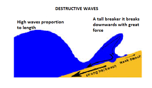
(b)Destructive waves
Destructive waves are the ones whose backwash is more powerful than swash and mostly causes destruction along the shore a line.
II.TIDES
Tides are the periodic rise and fall in the level of water in the oceans. Or regular periodic alternating rises and falls of the level of water in the oceans.
The rising of water level in a day is called flood tide, while the failing of water level in a day is called ebb tide. Tides commonly occur twice in 24 hours.
In day water rises to its highest level and fall to its lowest level to produce high tide (LT) respectively. The interval between the high tide and low tide levels is called tidal range.
Tides are produced as a result of pull of gravity of the moon and the sun, but the pull of gravity of the moon. Contributes more because of being closer proximity to the earth. The sun’s great mass, however causes it to have an appreciable
effect, despite its great distance from the earth. The moon attracts or pulls water to the side of the earth nearest to it. This creates a bulge or high tide.
effect, despite its great distance from the earth. The moon attracts or pulls water to the side of the earth nearest to it. This creates a bulge or high tide.

TYPES OF TIDES
Tides are classified according to:
Their varied degree of tidal range
Rate of occurrence in a day
According to their varied degree of tidal range, tides broadly classified into spring and neap tides.
Spring tide
It is the one with maximum tidal range produced when the moon and the sun are in alignment on the same side, increases gravitational attraction production same side, increases gravitational attraction producing the and lowest low tide. This is also known as syzygy tide in basis that, the position when the earth, the moon and the sun are all in straight line is called syzygy period.

2. Neap tide
It occurs when the sun, earth and moon form a right angle with the earth apex as result, the tidal range is made least, This is also known as quadrature tide, in basis that, when the moon, earth and sun are in such a position that they form right angle with the earth apex is called quadrature period. At this position the moon and the sun are pulling the water on the earth to themselves. The result is that, the force of each body is weakened. The high tide will also be lower than normal
According to rate of occurrence per tidal day, tides classified into the following types
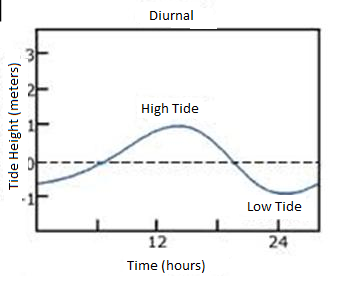
1. Diurnal tides
These are the simplest form of tides characterized by one high water and one low water per tidal day, It is very common in Northern Gulf Mexico and south East Asia
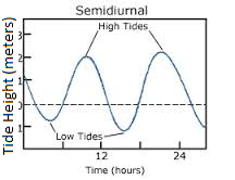
2. 2.Semi diurnal tide
-It is a form of tides, characterized by two high water and two low water per tidal day as the successive high water and low water levels are approximately equal. They occur provides, both the sun and moon are along the equator in a region at varied time per tidal day
3. 3.Mixed tides.
-The form of tides, characterized by having successive high water and low water levels stand differ appreciably i.e. There are higher high water level, and lower high water level as well as higher low water level and lower low water level per tidal day.


3 Comments