
Share this:
FORCES THAT AFFECT THE STRUCTURE OF THE EARTH
What are forces ?
Forces are the processes that operate (work) within or on the earth’s crust
There are different forces that affects the earth’s but can be grouped into two major types :-
There are different forces that affects the earth’s but can be grouped into two major types :-
1.Internal forces (endogenetic/endogenic processes)
2.External forces(exogenetic /exogenic forces )
2.External forces(exogenetic /exogenic forces )
INTERNAL FORCES (ENDOGENETIC/ENDOGENIC)
These are forces that operate within (inside) the earth’s crust
OR
These are forces which operates beneath (under)the earth’s surface. These forces are generally referred to as TECTONIC FORCES.
OR
These are forces which operates beneath (under)the earth’s surface. These forces are generally referred to as TECTONIC FORCES.
A word tectonic is derived from a Greek word tecton which means builder
♦ Tectonic means building
– internal forces(tectonic forces) which are divided into
– internal forces(tectonic forces) which are divided into
(1)Earth movement (Diastrophism)
(2)Vulcanism/ Vulcanicity/Volcanic erruptions
EARTH MOVEMENTS
These are also known as Diastrophism
Definition: is the movement of the solid parts of the earth towards each other or away from one another or side way.
Types of Earth movement.
Earth movements are classified into two (2) main groups:-
(i) Vertical or radial movements
(ii) Lateral or horizontal movements or tangential.
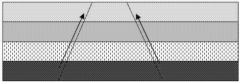
I ) VERTICAL OR RADIAL MOVEMENTS.
⇒These are the upward and downwards movements or forces .These forces cause the uplift (epeirogenic) and the downward movement (cymatogenic).
⇒These forces which causes the vertical earth movements operate from the interior upward toward the surface or downward from the surface to the interior.
These forces cause
(a) The crustal rock to fault. When faults develop produce feature like plateaus, basin, Block Mountain (host) and escapements.
(b) Sea level changes due to the upward lift of the land or sinking of the land.
(b) Sea level changes due to the upward lift of the land or sinking of the land.
NB: This changes in the sea level is not eustatic change (not eustatic movement)but is due to vertical forces.
⇒The eustatic change is the changes of the sea level due to ice melt during ice ages
II LATERAL/HORIZONTAL MOVEMENTS
These are also referred as organic forces (movement) because they are responsible for the build of the mountains (Orogenesis means the process of mountain building)
lateral forces are of two(2) types:-
These are also referred as organic forces (movement) because they are responsible for the build of the mountains (Orogenesis means the process of mountain building)
lateral forces are of two(2) types:-
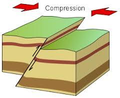
1) Compressional forces
2) Tensional forces.
2) Tensional forces.
Compressional forces: – Are forces which move towards each other ie move against each other.
– They tend to shorten the crust (the land) i.e. they squeeze the land.
They normally cause :-
(i) Folding of land hence fold mountains
(ii) Break the land to form faulting which may produce features like block mountains, rift valley and faults.
– They tend to shorten the crust (the land) i.e. they squeeze the land.
They normally cause :-
(i) Folding of land hence fold mountains
(ii) Break the land to form faulting which may produce features like block mountains, rift valley and faults.
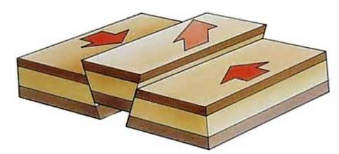
Tensional forces: – Are forces that tend to stretch the land i.e. the force move away from each other, they pull the land away.
–The forces cause faulting of the crust and produce features like faults, Block Mountains, rift valley.
FEATURES PRODUCED BY COMPRESSIONAL FORCES
1.Fold Mountains.
Fold Mountains are formed when a piece of the crust is subjected to compressional forces. These forces tend to shorten the crust so the land end up in folding(wrinkling or crumpling) hence develop fold.
-The earth’s crustal rocks produced upward fold known as anticlines (up fold) and downward folds known as synclines (down fold)
(a)Before folding (b)After folding

The anticline the crest part while the syncline is the trough part.

TYPES OF FOLDS
i)simple folds or symmetric fold:- the fold has equal limbs.

ii)Asymmetric fold :-is the fold with one limb steeper than the other.

iii) Over fold:-one limb is pushed over the other.
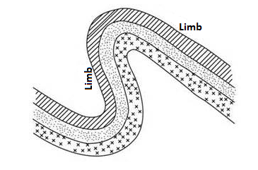
iv) Recumbent fold:-the limb is pushed over the other completely.
v)Overthrust fold(nappe):- when temperature is very great a fracture occurs in the fold (such that one limb breaks off)and the one limb is pushed over the other limb along the line of thrust plane

Example of fold mountains are Atlas (N. Africa), Aplas(in cape ranges in s. Africa),Himalayas(in Asia),Urals(in Rocky of N.America), Andes(s. America), Appalachian(U.S.A) Great divide range in Australia.
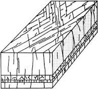
2) Rift valley (grabens).
This can be formed by both tensional and compressional forces.
Rift valley formed by compressional forces
How it formed:-
(a)layers of rocks are subjected to compressional force

b)Fault develop
c)The side blocks(outer blocks) move (thrust)upward over the center block
(d)later the over-hanging sides of the rift valley are removed (worn & back)by erosion

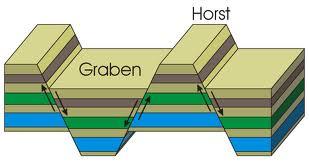
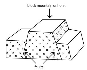
3) Block mountains (Horst) by compressional
Are formed when compressional force cause the formation of series of fault, such that the central block forced up (to form a block).Examples usambara, Ruwenzori, Vosges and Black forest.
How is block mountains formed by compressional force:-
a)A piece of crustal rock is subjected to compressional force


b) A series of fault develops.
c) The side blocks (outer blocks)and central block move (thrust) upward.

NB: Where series of faults occur both block mountain and rift valleys develop.
FEATURES PRODUCED BY TENSIONAL FORCES
Tensional forces can frm due to fault there are several features which may be produced they include Rift valley, block mountains(horsts) and fault.
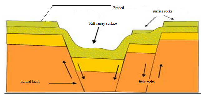
1)Rift valley (Grabens)
⇒ A rift valley is an elongated trough with steep sides.
⇒A rift valley can either be formed due to tensional or compressional forces .
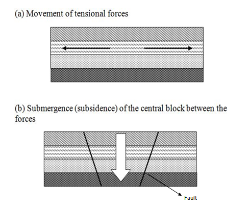
Formation of a rift valley by tensional forces
a).The line of weakness develop to form normal fault (Normal faults are formed )
b). The central block subsides(sinks)to form a rift valley
3. Block mountains (horsts) by tensional
These are tables like mountains formed due to fault
They are note extensive like fold mountains ,they have almost flat surface
Example Vosges and Black forest mountains(Europe) -Usambara, Uluguru in -Ruwenzori and Uganda boarder-Mount Sinai in asia.
Formation of blocks(horsts)by tensional forces.
a)A piece of crust is subjected to tensional force.
b)A series of fault develo

c)some parts subside leaving some standing high as block
where series of fault develop both block mountains and rift valleys are formed.
Fault scarp.
This is an escapement which is a steep slope when the land falls from a higher to a lower level
-it is formed soon after displacement

Note
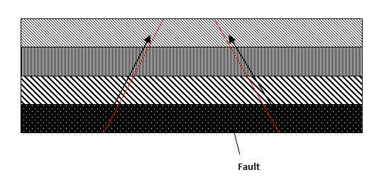
First -Tensional forces cause fault only
-Tensional forces cause the normal fault
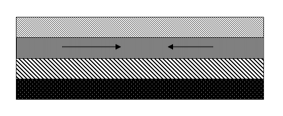
Second-compressional forces cause faulting and folding
-compressional force causes the reverse fault
Second-compressional forces cause faulting and folding
-compressional force causes the reverse fault
Faulting: is the process which involves the fracturing of the crust rock due to tectonic forces to form faults.
This process is associated with the movement. The rock block (i.e. rock displacement
A fault –is a fracture in the crust due to stress or strain associated with rock displacement.
Fault is cause by both tensional and compressional forces
Joint: is a crack in the rock due to stress but is not associated with rock displacement
-The paths of a fault on the surface of the earth s called the fault line (line of fault)
-some of the fault line may cover hundreds of kilometers.
FOLDING :is the wrinkling ,bending or crumpling of the earth crut producing upward folds(anticlines) and downward folds (synclines)
-folding is caused by compressional forces.
Significance of
features produced by earth movements(effect of feature produced by earths movement).
features produced by earth movements(effect of feature produced by earths movement).
-Both vertical and lateral force cause either folding and or faulting which in turn from fold and block mountains ,plateaus , rift valley basin and other feature s
These different features have the following positive (good)effects and negative( bad)effects.
Positive (good) effects
1.climatic influence mountain both fold and block receive orographic rainfall due to relief influence the windward side receive heavy rain at ll temperature are modified into cool(cold)
2.source of river : d to heavy rains and snow on mountains many rivers originate from them. Water used for irrigation.HEP generation, industrial and domestic uses.
3.source of minerals:-different minerals are obtained from fold mountain such as coal in Appalachian mountain gold in Colombia, silver in Peru.
-other mineral from block mountains example dolomite
4.attract tourism
Mountain skimming attract a lot of tourists for sporting activities (skidding) e.g. the cross Alps
-also rift valley forms a very attractive area due to presence of different lakes like Tanganyika , Natron, Manyra, Naivasha, etc ,presence of different volcanic cones and crater within it
5.slope of mountains have fertile soils for agriculture
Negative (bad) effects
1.The leeward side receive little or no rainfall hence hinder agricultural and a lot
2.sometimes folding causes some minerals to be buried deeper hence not easy to exploits
3.fault may cause some rivers to disappear I the ground
4.both mountains and rift valley hinder communication network
some mount sides are too steep or ruge, or have thick fog hidering both land and air transport
-earth movement also cause earthquakes and volcanic
EARTHQUAKE
These are sudden earth movements or vibration in the earth’s crust; they are caused by.
i. When one tectonic plate sliding over/or past another plate along the line of a faulty
ii. Volcanic eruption- The movement of molten rock below or onto the earth’s crust which in turn is caused by the movement of plates.
Nature of Earthquakes
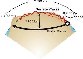
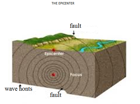
•The point of which on earthquake is originate is called focus. And sometimes it is several kilometres below the surface.
•The point on the earth’s surface immediately above the focus is called the Epicentre, This is where the shock waves first hit the surface. It is the shock waves which gives rise to an earthquake.
Types of shock waves
There are two types of shock waves:-
1.Body waves.
Are waves which travel through the erust and are of two types
i. Primary waves- which cause the crustal rock to move back and forth in the direction of wave movement
ii. Secondary waves- Are waves which cause the crustal rock to move side to side ie right angles to the direction of wave movement.
2.Surface wave.
These travel through the surface and are of two types
i.Love wave;- Which cause the surface rock to move side to side of right angles to the direction of wave movement.
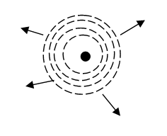
ii. Rayleigh wave;- Wave which cause the surface waves to have a circular movement very similar to that of water wave movement.
I/
II/
These travel through the surface and are of two types
i.Love wave;- Which cause the surface rock to move side to side of right angles to the direction of wave movement.
ii. Rayleigh wave;- Wave which cause the surface waves to have a circular movement very similar to that of water wave movement.
I/
II/
DETECTING MAGNITUDE AND INTENSITY
The intensity of an earthquake is measured by an instrument called seismograph, This is the instrument which record the vibration produced by an earthquake.
The magnitude of an earthquake -refer to the total amount of energy released and the scale which gives the magnitude is called the Richter scale, The scale range from 0 to 8.9
Effects of Earthquake
•Rise and fall of the sea floor Eg. Agadir Earthquake in Morocco in 1960
- Displacement of the earth’s crust, it can happen vertically or laterally.
- Land slides and open up deep cracks in the surface rocks eg. The El Asnam earthquake in Algeria 1954 destroyed an area of radius 40km and open surface cracks up to 3m deep.
- Destruction of infrastructure and properties
- Loss of life, can lead to death’s
- They can raise or lower erosion rocks eg. In Alaskan the earthquake of 189 lead to raise of some rock for about 16km.
2. VOLCANIC ERRUPTIONS/VULCANICITY/VULCANISM
The map above is a part of a recently released world map that shows, in blue, the presence of the underground water

The map above is a part of a world map that shows, in red, the presence of Active volcano centers
VULCANICITY
Vulcanicity is the range of processes by which molten materials and gases are either intruded (injected) or extruded (ejected) into the earth’s crust or into the earth’s crust respective
- Vulcanicity is the formation of various feature due to the intrusion or extrusion of molten materials, and gases.
- The molten materials are called magma when found within the earth’s crust and magma when poured on the earth’s crust.
Vulcanism/Vulcanicity – Is a broader term which includes both extensive and intrusive igneous activities while volcanicity – Refers to the extensive volucancity in which the materials are forced at onto the surface.
Origin of magma
Origin of magma is within the earth’s crust where it kept as a molten rock due the influence of temperature.
Magma can be ejected out through fissures or vent.
- Magma when passed through vent result the formation of volcanic features like volcanic cones.
- Magma when passed through fissures leads to the formation of lava plateau.
Types of vulcanicity
There are two types of vulcanicity which are classified as follows
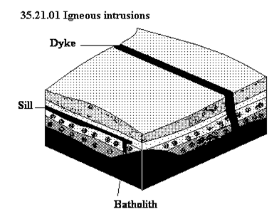
1. INTRUSIVE VOLCANIC FEATURES
1. INTRUSIVE VOLCANIC FEATURES
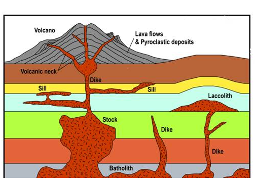
This is when magma intruded within the earth’s interior. The features resulted due to the intrusive volcanic erruption is called intrusive features.
The intrusive volcanic features are the features which are found within the earth’s interior. The following are intrusive volcanic features.
- Sill – is a rock sheet formed when the magma solidifies horizontally along the bedding plane. Eg:- Tyolo scarp in Malawi

- Dyke- is a rock sheet formed when the magima solifies vertically across the bedding planes. Eg:- Kinkon
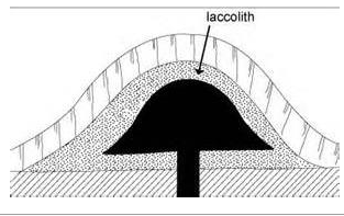
Laccolith is the cone dome shaped mass of rock with flat formed of viscus lava. It look like a mushroom. Eg:- Laccolith found in Morafonobe in Madagases.
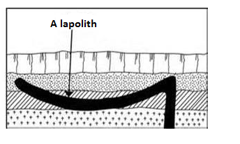
- Lapolith –is a scar shaped mass of rock formed in glosyncline. It forms a saucer – like shape may be due to the increased weight of the deposits
- Phacolith – is a leans shaped strip of igneens rock formed when the magima solidies along the anticline or syncline. Eg: Cordon wills in U.K Phacolith

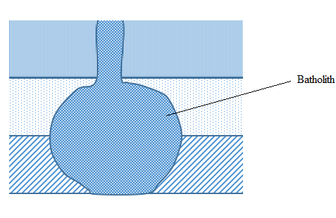
- Batholith is the large mass of solidified rock formed when magma cools plutonically at the great dept Eg: at the heart of the mountain ranges. Eg:- Chilu Batholic in Gabon
2.Extrusive volcanic features
Are the features formed when the magma cools and solidifies on the earth’s surface.
The extrusive volcanic features can be classified into the following
I. Central features
II. Fissure features
- The central features due to the violent eruption include
- Ash and cinder cone. Lava is blown to great heights when it is violently ejected and it breaks into small fragments which fall back to earth and build up a cone, example Busoka and Bitale in South west Uganda.
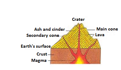
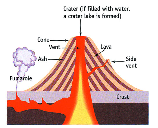
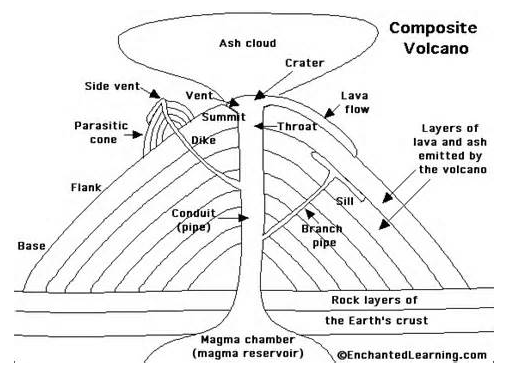
• Composite cone
This type of cone is formed of alternate layers of lava and ash. The volcano begins each eruptions with great violence forming a layer of ash. As the Eruption proceeds the violence ceases and lava pours out forming a layer on top of the ash, Lava often escapes from the sides of the cone where it builds up small conelets.Example mount Kilimanjaro in Tanzania and mount Cameroon

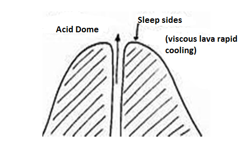
• Volcanic plug/plug dome volcano. Is a rigid cylindrical plug formed when very viscous lava is forced out of the volcano and form a plug dome that may completely block the vent. Good examples of a plug dome occurs in the Atakor volcanic area of Haggar mountains in Algeria. These are almost 300 plug domes in these region

• Crater is a depression formed on the summit of the cone after the plug dome has been blown off on the top of the cone.
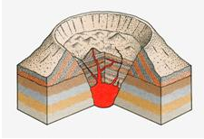
• Caldera is a large crater formed when the upper part of the volcano is either bombarded away by a violent eruptions or subsides into the crust. Eg:- Alaska, Ngorongoro in Tanzania, Eboga in Cameroon
Central features due to peacefull eruptions
The lava coming onto through the vent can be acidic and hence viscous or basic and hence less viscous.
The following are the central features due to peacefull eruptions
• Acid lava cone/comulo dome volcano- is the dome shaped volcano with convex slopes formed when acidic lava solidifies around the vent Eg:- Ntumbi dome (Mbeya)
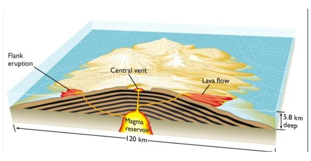
•Shield volcano:- is an extensive cone with gentle sloping sides formed when basic (basalt) is poured on the surface and spread to occupy large area.
Sometime times these features can be formed when lava comes out through a single fissure or many fissures.
Sometime times these features can be formed when lava comes out through a single fissure or many fissures.
• Fissure eruption
The fissure eruption involve lava coming out through a crack or fault. The feature formed is called lava plateau.

Minor volcanic features
A variety of minor volcanic forms can be distinguished, usually though not necessarily associated with volcanoes approading extinction. They include the following
•Mofettle – is the volcano which emit carbondioxide gas.
•Hot spring – is the volcano which emits hot water.
•With dissolved minerals suspension.Salfatara – is the volcano which emits sulphur gas.
•Fumerole – is the volcan which emits steam, mud and other gas than sulphur.
•Mofettle – is the volcano which emit carbondioxide gas.
•Hot spring – is the volcano which emits hot water.
•With dissolved minerals suspension.Salfatara – is the volcano which emits sulphur gas.
•Fumerole – is the volcan which emits steam, mud and other gas than sulphur.
OR:-
Is the outflow of superleated water from the ground which contains some mineral substances in solution or in suspension
Hot springs mostly occur in island or in some of the African countries such as Kenya and Ethiopia.

1.Geysers – are the forceful omission of hot water from the ground to high level in the atmosphere when emitted contains fine material forms mud volcano which later can lead to the formation of very fertile soild
- Types of volcanoes according to the activity
There are three types of volcanoes according to the activities. These include:-
I. Active volcano: is the volcano which erupts frequently. Eg:- Oldonyo Lengai in Tanzania and Mount Cameroon.
II. Dormant volcano is the one which has stopped erupting but not extinct and it is expecte to erupt.
The dormant volcano is also known as sleep volcano.
III. Extinct volcano. Is the volcano which has stopped erupting for a very lon time in history and is not expected to erupt.
It is also known as dead volcano.
INFLUENCES OF VOLCANIC ERUPTION TO MAN AND ENVIRONMENT
The following include the economic importance of volcanic eruptions to man.
i. Lava on weathering head to the formation of very fertile soil which support agriculture.
ii. Volcanicity eruption lead to the formation of mineral deposits like copper deposits of butte in USA, diamond of kimberley in South Africa.
iii. Volcanic eruption provide geothermal power for electric generation
iv. Some hot hot springs utilized for heating homes in glaciated region
v. Volcanic features attract tourist
vi. Volcanic cones are the source of rivers.
DISTRIBUTION OF VOLCANIC ACTIVITIES IN THE WORLD
Distribution of volcanic activities corresponds to the earthquake belts. They are common along the zones of convergence like in the circum pacific ring and Alpine – Himalayan belt, zones of divergence like Atlantic ridge belt and along the fealty belts like the African rift valley.
EARTHQUAKE
These are sudden movements or vibration in the earth’s crust caused by
i) One tectonic plate sliding over another along a line of a features
ii) Volcanic eruption – The movement of molten rocks below or on to the earth’s crust.
iii) Mass movements like landslides and rock falls. Can causes earthquake but in local scale.
iv) Falling of large objects from the atmosphere such as meteorites lead to the shaking of the earth’s crust.
v) Man’s activities or influence, such as quarrying rocks using explosive like dynamite, transept vellsel’s e.g trains and heavy trucks
THE NATURE OF EARTHQUAKE
FOCUS: Is the point at which an earthquake originates and sometimes it is several kilometer below the surface
EPICENTRE: Is the point as the earth’s surface immediately above the focus. This is where the shock waves first lit the surface. It is the shock waves which give rise to an earthquake.
There are two types of shock waves.
i) Body waves
ii) Surface waves
i) Body waves – this travel through the crust and is of two types.
a) Primary waves – Which cause the crustal rock to more back and forth in the direction of wave movement.
b) Secondary waves – Which cause the crustal rock to more from side to side that is at right angles to the direction of waves movement.
ii) Surface waves – These travel through the surface rocks and of two types
a) Love (L) waves which cause the surface rocks to more from side to side , at right angles to the direction of wave movements
b) Rayleigh (R) waves which cause the surface rocks to have a vertical circular movement very similar to that of water in a sea were. The vibrations caused by the surface wave produce most of the damage that occurs in an earthquake. The violent shaking of the surface rocks often cause great damage to buildings and sometimes considerable loss of life.
HOW TO DETECT AN EARTHQUAKE
The intensity of an earthquake is measured by an instrument called a seismograph. This instrument records the vibrations produced by an earthquake. The magnitude of an earthquake refers to the total amount of energy released and the scale which gives the magnitude s called the Richter scale. This scale ranges from O to 8.9. A magnitude of 2.0 is ten times greater than that of 1.0 and one of 5.0 is 10,000 times greater than one of magnitude 1.0.
The intensity of an earthquake – refers to the effect produced by the earthquake of course these varies from place to place so while the intensity of a specific earthquake varies its magnitude does not vary. It is important not to confuse magnitude with intensity.
EFFECTS OF EARTHQUAKES
1) Development of rift valley or basins
2) Landslides can occur and these in turn can lead to land degradation
3) Collapse of houses and other structures as well as loss of life. E.g in 1906 the earthquake killed a number of 700 people in San – Transits
4) Fire outbreak in cities, San – Transits damage due to fire outbreak.
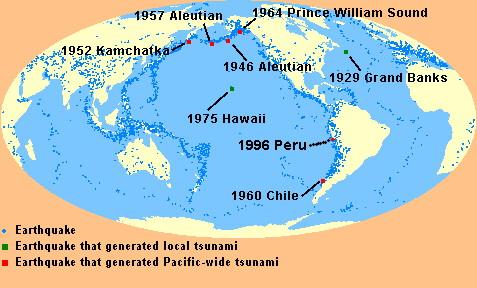
5) Tsunamis (waves in the ocean due to earthquake)
POSSIBLE AREAS WHERE EARTHQUAKE IS LIKELY TO OCCUR ON WORLD MAP.
EXTERNAL FORCES THAT AFFECT THE EARTH
External forces are the forces that operate on the surface of the Earth. The external forces leads to the modifications and formations of various land forms or land scape.
These external forces that operate on the earth′s surface include:-
WEATHERING
WEATHERING
Is the disintegration of rock exposed on the earth’s surface by the agents of weather particularly temperature and pressure release.
TYPES OF WEATHERING
There are three types of weathering. These are
I.Physical or mechanical weathering
Is the disintegration of rocks into smaller particles by mechanical means but without involving changes in temperature.
Mechanical weathering include the following processes
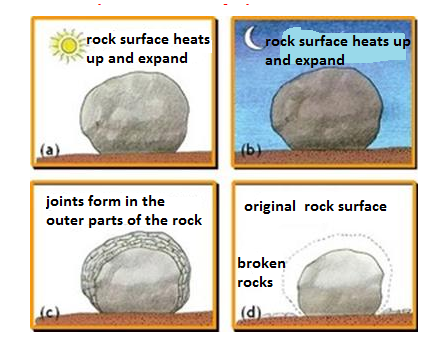
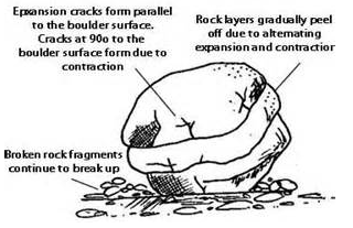
a)Insulation thermal expansion weathering – is the weathering which brought by temperature change.
During the day time the rocks expands and contract during the night leading to the creaking and breaking of the rock into small particles.
b) Exfoliation is the peeling off of outer layer of the rock like onion.
This is due to the fact that when the temperature is high the outer layer of rock warm faster than the inner layers and cool more rapidly. This cause the outer thickness to peel and form the smooth round hill called Exfociation dumes.
The rock particles deposited around the bottom of the dome is called Talus or scree
c) Granular disintegration
Is the breaking up of the rock which is consist of different minerals. These mineral contracts and expand separately through temperature changes.
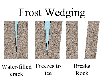
d) Frost action
This is common in temperature areas well as highlands and deserts.
When the temperature falls water in the cracks of the rock freezes. On free zing it expands leading to the widdening of the cracks. As the freezing repeating rocks breaks into fraguments or particles.
e) Pressure release
This take place where denudation has taken place to a great extent. As the materials are removed in certain area the pressure is released due to the reduction in weight. The rocks become weak and easly disentegrated by other process like exfoliation.
f) Salt crystallization
This take place when salt crystals deposited in the rock cracks or pores duri
ng evaporation. As the deposition goes on the crystals become large and exert stress upon the rock cause it to disintegrate.
ng evaporation. As the deposition goes on the crystals become large and exert stress upon the rock cause it to disintegrate.
This process is common in desert where there is capillary action or along the coast where there is constant supply of salt.
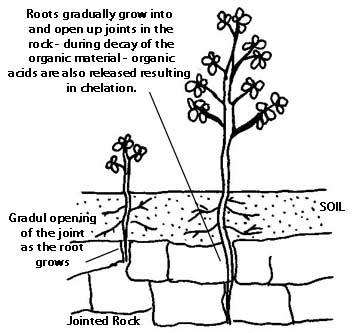
Biological weathering
Is the weathering where by the disintegaration of rock into small particles is influenced by plants and animals
Chemical weathering
Is the process which involves the decomposition or decay of the rock by chemical means.
FACTORS EFFECTING THE RATE OF WEATHERING
1.Nature of rock. The nature of rock include
•Mineral composition
•Plane of weakness
•Cementation
•colour
1.Nature of rock. The nature of rock include
•Mineral composition
•Plane of weakness
•Cementation
•colour
2.Climate. This is concerned with rainfall distribution. Areas with heavy rainfall the rate of weathering is h3.Plants and animals.Plant root penetration result disintegration of rocks. Animals borrowings and decaying of dead animal result rock decomposion.
4.Reliefs steepness of the land also determines the rate of weathering is high compared to low lands where deposition is common.
Chemical weathering processes
a) Oxidation. Is the oxidation of rock minerals particular iron when combine with oxygen in the presence of water.
b) Carbonation. Is the decomposition on of rocks particularly limestone with carbondioxide gas.
c) Solution Some rocks such as salt rocks are soluble in water and simply dissolve leading to the disappear once of the rocks.
d) Hydration is the process in which certain minerals absorb water and well causing internal stress and fructuring of rocks.
e) Hydrolysis. Is the reaction between water and mineral elements that is between hydrogen ion (H+) and the ions of minerals. It is common in felspar minerals which compensation potash soda or lime and silica
Effects of Weathering
1.Formation of various
2.features Soil formatio Eg:- Clints and Grikes in limestone region
3.It influences the rate of erosion.
4.It provide building material Eg:- Cement, blocks
5.It attract tourist since weathering result the formation of various features
1.Formation of various
2.features Soil formatio Eg:- Clints and Grikes in limestone region
3.It influences the rate of erosion.
4.It provide building material Eg:- Cement, blocks
5.It attract tourist since weathering result the formation of various features
MASS WASTING.
Mass wasting is the down slope movement of weathered rock materials due to the influence of gravity. The movement is not influenced or effected by transport agents such as wind or running water.
– When the movement of this nature occurs after the materials have been lubricated by rainwater or water from melting snow, it is referred to as mass movement. This force involved in mass wasting is that of gravity.
– In mass wasting, water acts as a lubricant and helps the materials to overcome the initial resistance where by the initial resistance is the friction between the materials and the underlying rock mass.
The movement can either be slow or sudden and rapid. The type (nature).
TYPES OF MASS WASTING
There are two types of mass wasting
I. Slow wass wasting
II. Rapid mass wasting
Slow mass wasting
This is the slow but stendy movement of rock debt is and soil down the stop.
This form involve the following processes.
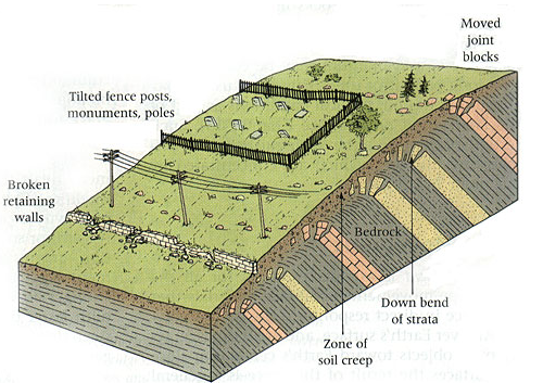
a) Soil creep. This is the steady movement involving soil and other fine materials along a very gentle slope.

Evidence that soil creep is taking place are
•Fence posts and telephones poles
•Stone walls
•Accumulation of soil at the base of slope.
•Stone walls
•Accumulation of soil at the base of slope.
b) Talus creep – is the mass of broken rock particles rock pieces that accumulated at the base of a rock mass such as a cliff.
c) Rock creep
Individual rock blocks moves down the slope slowly especially where the rock block lying over clay materials.
d) Solifluction
This is the movement of a mixture of soil, gravels and weathered rock down a moderate slope and the materials aare saturated with water.

Rapid mass wasting
This is the movement of materials in sudden and very fast way.
It involves processes like flowing, sloding or falling. Rapid mass wasting include the following.
a)Earth flow.
Materials on the earth’s surface get so saturated with water that they begin to flow down the will under the influence of gravity. This occurs in hummid region.
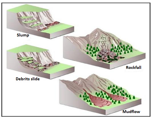
b)Mudflow.
Materials on the earth’s surface get so saturated with water that they begin to flow down the will under the influence of gravity. This occurs in hummid region.
b)Mudflow.
This is a flow of large quantities of mud down the slopes especial where the soil is bare
c)Landslide
c)Landslide
This is a rapid movement of a large mass of earth and rocks down a hill or mountain inside.
Forms of landslide.
i. Slump
This is the shearing or tearing away of rock materials. Usually occurs along a concave plance. It involve the large mass of soil, rock and other loose materials and vegetation.
ii.Debris slide.
This involve the movement of a whole mass of accumulated rock debris and other loose materials that produced through wealthering down a hill slope.
iii. Rock slide
The movement of rock mass sits on a fault or a weakened bedding plane on relative gentle slope.
iv. Rock falls
This is the rapid falling of individual rock brocks or boulders fleely form a steep slope.
v. Debris fall
This is the free falling of loose materials of various size from the top of a very sleep slope and cliff to the bottom of the slopes due to growty.
vi. Avalanches
This is the sudden sliding and falling of a large mass of snow Ice and loose rock materials down a montariside.
Factors influencing mass wasting
a) The nature and weight of the materials rapid mass wasting will occur 18 the weathered rock materials are very deep
b) Amount of water
If materials are more saturated with water are more likely to move than they are dry
c) The angle of slope
The steeper the slope, the faster the movement of materials
d) Climate
Mass wasting can be determined by the amount and nature of rainfall of an area receives. Areas receiving heavy experiences massive mass wasting.
e) Vegetation
Plant cover hold materials hence reduce amount of movement, hence bare surface experience active mass wasting.
f) Human activities
Eg. Cultivation Construction grazing animals mining and clearing of vegetation render the surface bare and unprotected, shake the land cause materials to move.
Effects of mass wasting on the environment
1) Soil erosion. As materials move down the slope especially where rapid movement is involved, they remove some soil to other area.
2) Formation of new landforms.The process can lead to the formation of scars and depression.
3) Formation of lakes.Materials of land slides can be accumulated and form a barrier to the flowing river hence eventually form lake due to accumulation of water blocked.
4) Formation of fertile soil.The material from fertile land accumulated at destination form fertile soil. At the place.
5) Demage of property.Various forms of mass wasting lead to the damage of propartly like telephone lines and power transmission
6) Loss of life.
€Μυδφλοωσ, σλυμπσ, ροχκ φαλλσ ανδ αϖαλανχηεσ χαν χαυσε γρεατ λοσσ οφ πεοπλε•σ.
iii. (a) EROSION AND DEPOSITION BY RUNNING WATER.
iii. (a) EROSION AND DEPOSITION BY RUNNING WATER.
Erosion – Refers to the breaking and wearing a way of exposed rocks by moving water (rives and waves), the wind and moving ice and wind. Water, wind and ice are called effects of erosion.
Deposition – It is the process which sediment, soil, roc
ks is accumulated to a certain place.
ks is accumulated to a certain place.
Running water – The process associated with running water fluvial process. Running water can take form of over land flow (surface runoff) or channel them (river). In the surface runoff water flows on the surface forming uniform cover while in channel flow (river) water flows in the specific channels.
i. Over land flow (surface Runoff)
Is more effective on bio and upper slopes and undergo the following types of erosion
(a) Sheet erosion
(a) Sheet erosion
– Remove the uniform cover of the soil
– It is common in gentle sloping areas, which are bare of vegetation.
(b) Rill erosion
(b) Rill erosion
– Produces small groves on the surface called mills and it takes place after sheet erosion has produced a mumble of tiny streamlets.
(c) Gully erosion
(c) Gully erosion
– Take place leading to the production of deep trough into land, this is more concentrated, if vell erosion has not been checked by planting trees.
Surface Run –off and its features Produced
i. Rills – These are small channels produced on the surface due to rill erosion

ii. Gullies
Are deep steep – Sided through produced by gully erosion, they are formed when rills are depended and widened by more concentrated erosion.

iii. Bad lands
This is the landscape which has been proken up by many gullies and channels due to erosion.
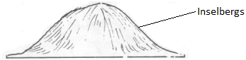
iv. Inserbeng
Round topped hills produced as remounts of hard rock after All other pants have been eroded.


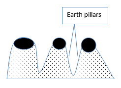
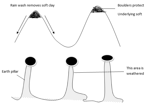
v. Earth pillars are columnar (tower like) structures standing vertically on the surface due to the removal or erosion of clay and boulders on soft rocks.
RIVER AND RIVER SYSTEM
Rivers are the most widespread agent of denudation. They transport and deposited material for very great distance, aft
er hundreds and sometimes thousands of kilometers.
er hundreds and sometimes thousands of kilometers.
The amount of erosion, transportation and deposition that a river achieves depends on the flow of water through its channel and this flow is determined by several factors.
The energy which makes the flow possible, is produced by gravity, and the amount of energy that a river has is related to the gradient of its bed, to its volume and the nature of its flow and to the shape of its channel usually, the energy increases when the gradient and the volume increases.
Water in river flows in two ways
- Laminar flow (in layers parallel to the bed)
- Turbulent flow ( in a circular – like mariner)


The energy of a river decreases when its flow is turbulent because energy has to be used to overcome the fuction within the water caused by turbulence.
The shapes of a channel also affect the amount of energy a river has for erosion and transport. A river uses more energy to flow through a flat, mite channel than through a narrow, deep channel because the former has a large surface area, and frictional drag is therefore greater.
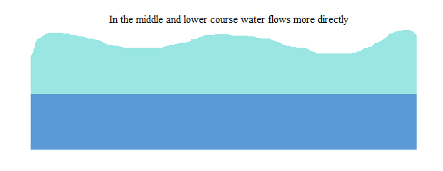
In the upper part of a river’s carve the gradient of the channels is steeper but the volume of water is less. In the middle and lower part of a river’s carve the average velocity of the river is at least equal to and in some cases greater them, the velocity in the upper part. This is because of the turbulent upper part of the curve.

River Erosion
Involve a matrix of interacting processes namely
– Hydraulic action
– Corrosion (abrasion or Rasping)
– Attrition
– Corrosion (solution)
a) Hydraulic action
Is the process where moving water sweeps away the loose materials like silt, gravel, pebbles.
b) Corrosion, abrasion or Rasping
Is the wearing away of the bed or the banks of the river by the load carried by the river water hence the amount of load determines the nature of erosive power and the rate erosion
c) Attrition
Is the process of wearing away or breaking down of the load itself as fragments collide with each other and against the river bed.
d) Corrosion (solution)
Some minerals dissolve in water leading to the disappearance of the rocks
Hence: these four processes constitute river erosion which enables a river to cut a channel into the land and it operates into 3 ways namely.
- Head ward erosion – Is cutting back of the river and its source.
- Vertical erosion – Involves undercutting into a river bed which leads to the depending of the river valley.
- Lateral erosion – is the wearing away of the riversides

RIVER TRANSPORT
All the material that a river transport is called its load: A river transport its load in four ways
- By traction: ( the dragging of large piece of materials such as pebbles along its bed)
- By saltatoin ( the bouncing of smaller pieces over its bed)
- By suspension of light materials, such as silt and mud in the water.
- By solution of certain minerals which dissolve in water.
NB: A river loses energy when its gradient decreases when its channel widens, when it meanders (twists and turns) and when its volume decrease after a flood.
During times of flood the volume of a river increase and its energy therefore increase, which results in more erosion, which is turn leads to an increase in the river’s lead. But when the floods subside, the volume decreases and so does the energy. The river now has too great a load, its power to erode decrease and deposition takes place.
RIVER DEPOSIOTN
Deposition takes place when a river has insufficient energy to carry all its lead. The first part of the load that is dropped consists of boulders and pebbles. The last part that is dropped in fire sedimentary, called silt.
Deposition takes place at any point in a river’s course. Material is constantly being deposited, picked up again and transport to another part of the bed where it is again deposited.
Factors which influence River deposition are as follows
- Decrease of the volume of the river
- Decrease in the velocity (speed) of river water
- Presence of an obstacle
- Stagnation of water when the river enters the sea or lake or the flat land.
THE DEVELOPMENT OF A RIVER VALLEY
When rainfalls, some of it soaks into the ground, some evaporates and some runs off the surface the letter sometimes gives rise to stream which liter join together to form rivers. Although a river can also develop from a spring or a lake or mass of ice most rivers start in upland regions where rainfall is usually high through ant the year.
The surface run – off forms small streams in the area where a river beings. The internal streams join together to give a river. The juretion of two streams or of a stream and a river or of two rivers is known as a confluence. When a smalle
r flow (earth a stream or a river) joins a large flow, it is called a tributary.
r flow (earth a stream or a river) joins a large flow, it is called a tributary.

The erosion power of a river depend on its volume and its gradient and as we have already seen. This power changes whenever there is a change in the volume or the gradient.
A river erodes to its level, i.e. the lowest level to which a river can cut vertically. The base level may be the confluence with another river, the surface of a lake or the surface of the sea.
All base levels are temporary except the sea which is the ultimate base level.
If the draw a line following the course of a river from its source to its month, this line is called the long profile of the river. This line usually has a concave slope.
THE LONG PROFILE OF THE RIVER
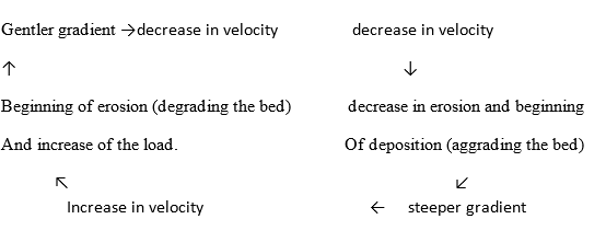
The profile a river is always changing. For example, if a river does not have a fall load in one reach (a reach is the name gives to any part of a river’s course) then the river will erode its bed. This results in addition of eroded material to the load. This erosion of the river’s bed described as degrading the bed. Never, erosion decreases in the lover part of the reach because more energy is needed to transport the increased lead. Thus the gradient is less steep and there is a decrease in the river’s velocity. Eventually to velocity of the river in that reach enables erosion to balance deposition. This means that the amount of material removed from the river’s bed is abort equal to the amount deposited on it. On the other hand, position will take place if the river enters as reach whoso gradient is less steep than that of the reach it has just left. This will course the river’s velocity to decrease and part of its land will be deposited. This deposition on the river’s bed is described as aggrading the bed, and it results in the gradient being steepened causing the velocity to increase again. This recurrent action of erosion and deposition on a river’s bed can be summarized as follows.
The long profile is really made up of a series of part, each of which is balanced the factors velocity, depth, width and discharge. If one of these factors changes, then all of the remaining factors will be affected. It is sometimes possible to divide the long profile into stages/sections.
STAGES IN THE LONG RIVER PROFILE
When the river profile develops it leads to the emergence of stages if the river namely young or upper state, mature or middle stage and Old or lower stage.
Each section or stage has its characteristics where these features vary due to the variation in the rocks structure, topography and nature of erosive process.

- YOUNG STAGE/ UPPER SECTION
It is called a youthful stage or torrential stage it is a stage where sources of the river can be traced, in this stages the river is very fast and erodes, vertically forming V – shaped valley. The river becomes very powerful due to its high speed.
– Has steep slope
– River flows through later locking spums
– Has rapids and water falls( waterfalls are sudden flows of water)
Condition leading to the formation of waterfalls
- The water falls can be formed where the hard rock layer lies horizontally or the soft rock layer, the water erodes the soft rock layer

- When the hard rock dips gently upstream

- When hard rock stands vertically

- Waterfalls can develop along the edge of steep sides of the plateau

- MATURE STAGE/ MIDDLE SECTION
It’s also know as valley stage, whose valley are widened by the process of lateral erosion, at this stage the speed of the river is slower, many tributaries are developed joining main river, which again increase the volume of water, meander’s develops, cliffs are developed across the river or valley floor.
- OLD STAGE/ LOWER SECTION
It is also referred to as the plain stage its main features are development of flood plain, braided stream, meanders, ox Bow Lake, and levees, deferred tributaries, lagoons and estuaries. When a river reaches old stage, the land is almost flat and its speed is very slow such that the main task is Deposition because the volume of the river is at its maximum due to addition of more attributes when course materials are deposited first and five materials are deposited at least in the rivers mouth.
The meanders are more pronounced than in the middle stage.
Characteristics of Old Stage are
- Formation of the braded river resulted from silt deposits into small channels (braids)

- Formation of flood plain due to the deposition of alluvium (silt and sand).
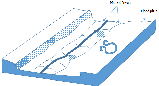
- Natural levees
These are ridge like or embankments produced as a result of deposition of sediments along the banks of the river in the flood plain.
- Ox bow lakes (cut – off)
Are cut off meanders formed as a river cuts through the necks
Ox bow formation

1) At A the river has just developed meanders
2) At B the meanders has become more pronounced forming a loop
3) At C a river has at through a neck isolating at a bend, which later former an Ox bow lake.
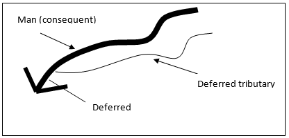
- Deferred Tributary (Yazoo stream)
Is a tributary is a lower course forced to flow alongside the main valley or (consequent) valley. For long distance before joining the main stream.

- DELTA
A delta is a low – lying swampy plain which gradually becomes colonized by various typed of plants. It formed when load carried by rivers is eventually deposited in the oceans, the seas and the lakes into which rivers drains. Sometimes the deposited load is carried for way from the mouth of a river before it sinks to the bottom, but sometimes the deposited load sinks to the bottom in the mouth of the river when this happens, layer upon layer of sediments may collect to form a gently sloping platform. In time, the platform may extend up to the surface and above, when it is called delta.
For the formation of a delta the following conditions are necessary
- A river must have a large load
- The velocity of a river must be sufficiently low to allow most of its load to be deposited in the river’s mouth.
- The river’s load must be deposited faster they it can be removed by the action of tides and currents. The river Congo has a large load but high velocity near its mouth which enables most of its load to be carried for cat to sea thereby preventing the formation of a delta. The River Niger also has a large load, but its velocity near its mouth is low. Much of its load is deposited in its mouth where an extensive delta has formed.
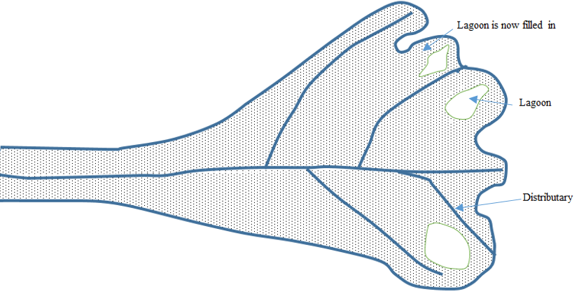
There are stages in the formation of a delta in an ocean or sea.
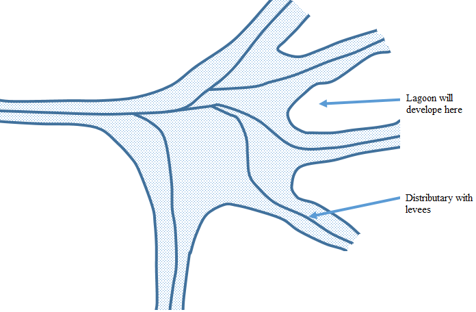
In stage 1: Depositions in the river’s math cause the river to divide into several distributaries. The delta beings to form when the initial sediments collect on the continental shelf around the river’s mouth. As the deposition continues, layer upon layer, a low platform develops. Reposition on the banks of the distributaries produces levees and the areas of water bounded by distributaries become the sites for feature lagoons.
In Stage 2: Some lagoon has already begun to fill with sediments which cause further division of distributaries into small distributaries. The delta has a more solid appearance. Though it is still very swampy and is usually well covered with water loving shrubs and trees.
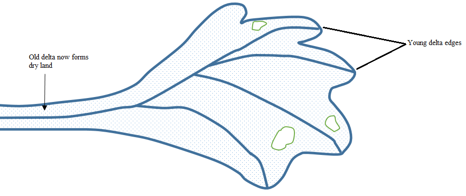
In stage 3: further in filling of lagoons plus the growth of a complete covering of vegetation results in the older parts of the delta coming to stand above water level and form dry land.
A delta’s size and shape depended the type and amount of deposited sediments and also on the power of waved and currents. There are basic types of delta
1. Arcuate; this delta consist of both course and fine sediments and its has the shape of an inverted cone. It is crossed by numerous distributaries. God examples of this type are the deltas of the Niger, the Nile the Ganges, the Indus and the Hwang – Ho

2 . Bird’s foot. This delta consists of very fine material, called silt and it has a few long distributaries bordered by levels that just out from the share. This type formed when power of the waves and currents is low. Example the Mississippi Delta.

3. Estuaries. This delta is formed from materials deposited in the submerged mouth of a river. It takes the shape of the estuary.
4 . Cuspate delta – This is a delta which looks a tooth-shaped feature. It is formed when a rive drops sediment onto a flat, straight shoreline with strong waves. Waves force the sediment to spread outwards in both directions from the river’s mouth, making a pointed tooth-like shape with sides curved by regular opposing, gentle water movement. A cuspate delta extends to the sea as a V shape with long curving sides. Examples of such a deltas are Ebo in Spain and Tiber in Italy.

River Rejuvenation
Is the process where a river is renewed after being affected by fall in the sea level land uplift and subsidence and the increase in the river volume.
Hence: River rejuvenation is
caused by
caused by
a) Fall in the sea level (Eustatic change) which is done by earth movement trough diastrophic disturbances.
b) Land uplift and subsidence / isostatic change
c) The increase in the river volume, when the river volume increase power also increases due to heavy rainfall or snow melting.
TYPES OF RIVER REJUVENATION
Rejuvenation can be categorized as Dynamic or static rejuvenation
i) Dynamic rejuvenation
Rejuvenation – Is brought about by either sea level change or land level change. Hence can be again categories into.
- Eustatic rejuvenation
It is due to the change in sea level
- Diastrophic rejuvenation
Is due to by land uplift subsidence and flitting caused by faulting.
ii) Static Rejuvenation
Is the type of rejuvenation caused by the increase in the river volume due to either heavy Rainfall or melting of ice or river captures.
Effects of River Rejuvenation
River rejuvenation leads to the following features
- Knick point (rejuvenation head)
Is the break of slope in the long profile of the river valley.
- Paired Terraces
Are steps or benches on either side of the river valley formed as a result of undercutting of the river.
- Incised meanders
Are steep sided curved bends of the river valley produced as result of undercutting of the river bed. Incised meanders are of two types.
- Ingrown meanders
Meanders are asymmetrical sides of a cross profile of the river

- Entrenched meanders
Is a steep sided symmetrical meanders with sides stand vertically and parallel to each other it is produced by vertical erosion
- Incised meanders Terraces
Involves services of terraces along the incised meanders produced by vertical under cutting in the river valley that has undergo rejuvenation. It produces features like
- A waterfall drops sharply from the knick point.
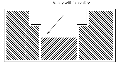
- Canyons and gorges
- Valley within a valley. Is a new valley formed within the former pre existing valley.
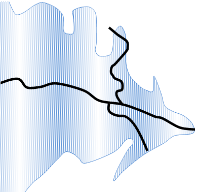
RIVER CAPTURE
River capture (River piracy) – Is a process whereby one river diverts the course of the other neighboring river into its own course.
It’s happen when there are two adjacent rivers and one is more powerful than other, then the more powerful river may capture its weaker neighbor. For this to happen, the more powerful river must flow at a lower level and it must erode its channel, both head ward and vertically, at a faster than its neighbor. This can take place when the more powerful river flows over rocks that are easy to erode or when it flows down a steeper slope than its neighbor. If either of these conditions occurs, then river capture takes place.
Conditions Necessary for River Capture to Occur
River capture occurs when is existence of the following condition
i. The capturing river should be stronger or must have greater energy for the vertical and head ward erosion than the other.
ii. The capturing river must be flowing at a lower and usually steeper gradient that its victims.
iii. The capturing river must be flowing over easily eroded, rocks that are weaker rocks.
NB: river capture is common in the trellised pattern where there is faulting
Feature Due to River Capture
i. Elbow: This bend produced where the river has been diverted (changed). However not all right angled bends in rivers are due to river capture.
ii. Misfit (under fit stream): Beheaded stream heaving slot head water due to river capture and has been reduced in volume such that it becomes too small for its valley.
iii. Wind gap (Dry valley): The valleys of the beheaded stream below the point of capture or elbow and may be filled up with gravel or alluvium.

Examples of River Capture in Africa
i. Tiva River Capture in Kenya
ii. Cunene River Capture in Angola
iii. Nsaki River Capture in Ghana
iv. Imo River Capture in Nigeria
DRAINAGE PATTERNS
All the rivers are joined by smaller rivers or stream which are called tributaries .The area drained by rivers and the its tributaries is known as a rivers system or catchment area and its boundary is usually formed by the crest line of the surrounding highland called the watershed .
The watershed separates one basin from the next basin. The main river and all the its tributaries together form a river system.
A river system develop a pattern that is related to the general structure of its basin . There are these basin river system patterns.
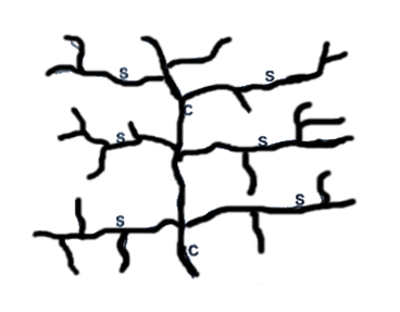
(i)Dendritic: This pattern has a shape like the trunk or branches of a tree with the tributaries joining the main stream is called a consequent stream or(river) because it develops as a consequence of the slope This drainage pattern develops on rocks of uniform structure and hardness

(ii)Trellis : A trellis pattern develops in a region which is made up of alternate belts of hard and soft rocks , which all dip in the same direction and which lie at right angles to the generally slope down which the consequent stream flows . The tributaries extend their valleys by head ward erosion into the weak rocks which are turned into wide valleys, whilst the hard rock stand up has escarpments . The tributaries which cut out the valleys and which do not flow down the main slope , are called subsequent rivers. This pattern develops in scarp land regions and regions of forded rocks.


(ii)Trellis : A trellis pattern develops in a region which is made up of alternate belts of hard and soft rocks , which all dip in the same direction and which lie at right angles to the generally slope down which the consequent stream flows . The tributaries extend their valleys by head ward erosion into the weak rocks which are turned into wide valleys, whilst the hard rock stand up has escarpments . The tributaries which cut out the valleys and which do not flow down the main slope , are called subsequent rivers. This pattern develops in scarp land regions and regions of forded rocks.
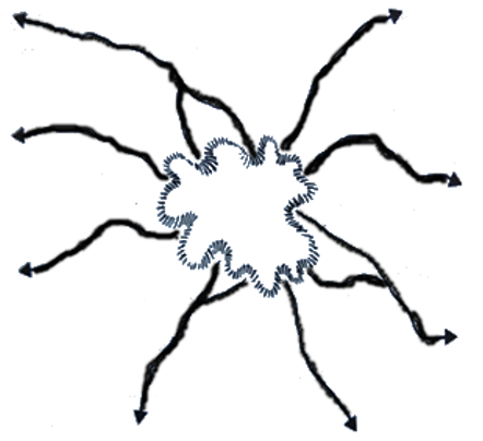
(iii) Radial , This pattern develops on a dome or cone shape upland , such as volcano. The rivers flow outwards forming a pattern like the spokes of a wheel.

HYDROLOGICAL CYCLE
Hydrological cycle in the endless or continuous interchange of water between the atmosphere, the earth (land) and water bodies. It is the circulation of water from ocean into the atmosphere through combined effects of evaporation , transpiration, condensation and precipitation

Evaporation: The process in which liquid water turn into water vapour and rises up.
Transpiration: The loss of water vapour from plants in the form of vapour to the atmosphere.
Condensation: The process in which water vapour turns into the liquid form following a drop in atmospheric temperature. The temperature at which condensation takes place is called dew point. The dew point is the temperature at which the water vapour in air at constant barometric pressure.
Precipitation: This refers to any product of condensation of atmospheric water vapour that fall under gravity. The main forms of precipitation include drizzle, rain, sleet, snow, hail and graupel. Precipitation occurs when a portion of the atmosphere becomes saturated with water vapour, so that the water condenses and “precipitates”.
UNDERGROUND WATER
When rain falls, some water forms streams (surface run off) while some penetrates into the ground (percolation process). The water that seeps into the ground forms underground water. Water enters the rock in two ways:
- Via the spaces, called pore spaces, separating the individual grains of rock; and
- Via the joints or faults in a rock.
Percolation:
This refers to the process in which water on the ground surface seeps down into the ground.
Porous rock:
This is a rock which has pore spaces into which water can infiltrate, e.g. sand, gravel, sandstone, etc.
Pervious rock:
This is a rock which has joints or faults into which water can infiltrate, e.g. limestone, chalk, and granite.
Permeable rock:
This is a rock which allows water to penetrate through it, e.g. they have open texture and have poor cementation. They include limestone, sand, gravel, sandstone, etc.
This is a rock which does not allow water to pass and penetrate through it, e.g. clay.
Some rocks are both porous and permeable, e.g. sandstone, and some rocks are porous but impermeable e.g. clay. When the pore spaces of a rock are filled with water, the rock is said to be saturated.
Water table
The water table can be defined as the depth at which the ground becomes saturated with water. It can also be defined as the level below which the ground is completely saturated with water. The saturated zone beneath the water table is called an aquifer, and aquifers are huge storehouses of water.
Water zone
The water entering surface rocks moves downward until it reaches a layer of impermeable rock when further downward movement ceases. There are three water zones as explained below:
Zone of non-saturation: This is the zone which is filled with water only during a precipitation. In this zone pores have open textures that allow water to pass through them. The zone is found immediately below the surface.
Zone of intermittent saturation: this is the zone which is filled with water and remains with water for a long time during heavy rain. the pores of this zone are filled with water during a heavy rainfall but after the rainfall ends it becomes dry.
Zone of permanent saturation: This is the zone which is always saturated with water. It does not become dry rather than extending far deep in the ground. It is suitable for sinking permanent wells. The last two zones, that is, zone of intermittent and non-saturation zone are sometimes called phreatic since they saturate only once.


Wells and artesian wells
A well: A well is the hole sunk below the water table. Always wells which are sunk below the water table (i.e up to zone of permanent saturation) have water throughout the year.
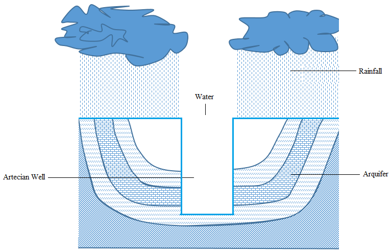
Artesian well: This is a well which sinks in the aquifer of an artesian basin. When a well is sunk into an artesian basin, the hydrostatic pressure in the ground forces the water to come out. The artesian well in which water does not reach the surface is called semi-artesian well.
Spring: A spring is a natural of outflow of underground water to the surface. Some springs are permanent if the water table is permanent and they can be temporary if the water table is temporary also.
Formation of a spring
I. It may be formed when a impermeable rock underlie a permeable rock in a hill. In this feature the permeable rock lies on top of an impermeable rock causing water outflow.


II. A spring may also be formed when well-jointed rocks form a hill.

III. When a dyke acts as a dam. If it cuts across a layer of permeable rock then the water on the up-slope side of the dyke is impounded. This causes the water table to rise and a spring develops where the water table meets the surface.


IV. A spring may also be formed in a limestone region when chalk or limestone escarpments overlie impermeable rocks
V. When gently-sloping layers of a permeable rock alternate with a layer of impermeable rock.
Importance of underground water
i. It is very important in the weathering of rocks; hence it assists in soil formation.
ii. The springs and wells provide water for domestic
and industrial uses such as drinking e.g. the Mzima spring in Kenya.
and industrial uses such as drinking e.g. the Mzima spring in Kenya.
iii.It is very important for growth and survival of plants and some living organisms found in the surface soil
iv. In developed countries, hot springs have been harnessed for heating up houses during severe winters (e.g. in Iceland and Greenland) as well as for hydro-electric power generation.
v. It is very important in the growth of Karst (hanging stone) features which attract tourist, hence source of foreign exchange. For instance, stalactites, stalagmites, pillars and caves.
KARST LANDSCAPE
Karst landscape is a landscape formed from the dissolution of soluble rocks such as limestone, dolomite and gypsum. It is characterized by underground drainage systems with sinkholes, dolines and caves.
Limestone consists chiefly of calcium carbonate (CaCO3) which is insoluble in pure water but it is soluble in rain water containing a weak carbonic acid (H2 CO3). Limestone is a well –jointed rock. The rain water and river remove limestone in solution. The carbonic acid in rain water dissolves limestone into calcium hydrogencarbonate, which is soluble an can easily be washed away in solution.
H2CO3+CaCO3Ca (HCO3)2
In this way, limestone regions may be removed or washed out to produce the following surface and underground features:
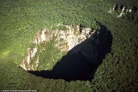
Sinkhole – a vertical depression or hole in the ground, sometimes called shallow hole, formed by river that sinks down when passing through a limestone region. It can be a source of an underground river.
Doline – a large depression formed when several shallow holes join together.
Uvala – a large depression formed when several dolines join together.
Polje – a very large depression that develops in association with faulting. It is a feature which is formed when several uvalas collapse, the collapsing associated with faulting. It usually covers several square kilometers (usually 5 to 400 km2).

Stalactite – an outcrop rock in the cave growing from the roof of the carven towards the floor.
Stalagmite – an outcrop rock in the cave growing from the bed of the carven towards the roof.
Pillar – a feature formed in a limestone cave when a stalactite and a stalagmite join together. It is sometimes called natural pillar.
Cave or cavern: A cave or cavern is an underground hole formed due to solution of limestone rock. First, the tunnels are formed, followed by enlargement of a hole. Caves form naturally by the weathering of rock and often extend deep underground.

An example of a limestone landscape is the Matupi cave in Hoyo mountain in DRC.
Features formed by rain action
Rain action produces several types of features of which the most common are gullies and earth pillars
1. Gully
This is a deep formed by the action of running water on gently sloping land that has little or no vegetation. Gullies are sometimes referred to as badlands. They develop largely in semi –arid areas.
2. Earth pillar
This is the up-standing ridge capedwith boulders. It is formed when rain falls on the mountain slopes consisting of boulders and clay is removed rapidly except where boulders protect it.
WIND ACTION AND THE FEATURES IT PRODUCES
Wind refers to the air in motion from high pressure to low pressure belt. Wind action is very powerful in arid and semi-arid regions. Examples of deserts include the Sahara, in Africa, Namib, Kalahari and Gabi deserts.
Types of desert surfaces
Sandy Desert (Erg): This is a undulating plain
of and whose surface is blown into sand dunes and nipples. The Sand Sea of Egypt and Libya is a good example of an erg.
of and whose surface is blown into sand dunes and nipples. The Sand Sea of Egypt and Libya is a good example of an erg.
Stony Desert (Reg): This consists of extensive areas with boulders and stones produced by daily temperature changes. Most of story deserts are formed in Algeria, Libya and Egypt
Rocky Desert (Hamada): This consists of extensive areas of bare rock from which all fine materials have been removing by deflation. Abrasion by the fine materials polishes and smooths the rock surface. One of the largest Hamada is Hamada el Hamra, in the Sahara of Libya.
Badlands: This is a land broken by extensive gullies, separated by steep-sided ridged. This type of desert is quite different from the three deserts explained above, in that it develops in sem-arid regions which experience sudden violent rainstorms.
WATER ACTION IN THE DESERT
Running water in the desert result the formation of fluvial features.
Fluvial features
Are the features which resulted due to the influence of water action.
The fluvial features can either fluvial depositional features or fluvial erosional features.
DESERT FLUVIAL EROSIONAL FEATURES
Desert fluvial erosional features are also known As Desert water erosional features.
These are the erosional features which caused water action in the desert.
Desert fluivial erosional features include the following.
i. Rills: –
i. Rills: –
Are the small shallow grooves formed due to rill erosion effected by surface run off
ii. Gullies: –
Are deep steep sided trough produced when erosion in the rills become more concentrated into the ground

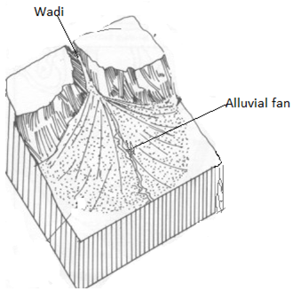
iii. Wadis: –
Are the steep sided deep and often flat floored valleys formed due to severe erosion by water in the desert.
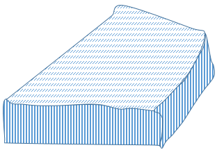
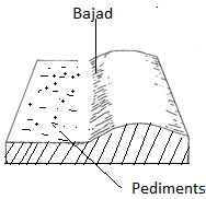
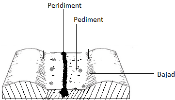
iv. Pediment.
Is a gently sloping platform formed when edges of the desert and semi desert high lands get pushed back by erosion and weathering.
The process whereby pediments is called pedimentation.

v. Pedi plans / Pad planes
– Are the multiconcave features resulted by several adjacent of large scale pediments.
– They are formed as a result of wide spread surface water erosion on the surface in desert areas.
WATER DEPOSITIONAL FEATURES IN THE DESERT
Are the depositional features formed when the materials carried by running water accumulated and deposited in some parts of the desert surface.
The desert water depositional features include the following.
- Alluvial cones.
Are the features which look like alluvial fans in shape but consist of coarser materials
– They are formed when large coarser materials deposited at the foot of steep slope. Thus, they are formed in the same way to alluvial fans.
- Bajads or Bahadas.
Are the continous gentle sloping features with undulating surface formed when either alluvial fan or alluvial cones coalesce during deposition of more sediment at the foot a steep slope.
– They consist of angular scree, gravels and coarse sands around the margin of the basin.
vi. Inselbergs: –
Are the residual hills or rock masses formed by water erosion in the desert
– They are always rounded and smooth
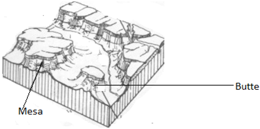
vii. Mesas and buttes
Mesas are extensive flat topped residual table lands which are generally capped with resistant rock stratum.
Buttes are the small but prominent residual flat topped hills usually capped with resistant rock stratum which remain a mesa and are similar to mesas except that they are small.
viii. Dry river valleys.
Are the river valleys which remain dry after the streams of water dry during dry season in the desert landscape or along the base of the mountain range in the semi desert area

ix. Peripediment.
ix. Peripediment.
Is a feature with a gentle slope formed when alluvial deposits overlie the edge of the pediment.
x. Plays and Salinas
Are the temporary salt lakes. Somet
imes these playas dry up produce salt beds or salt flats called Salinas or Salas.
imes these playas dry up produce salt beds or salt flats called Salinas or Salas.
WIND ACTION IN THE DESERT.
Wind action is also known as Aeolian. It causes erosion transportation and deposition of materials in the desert.
WIND EROSION
Refers to the remove of particles on the desert surface.
Wind erosion consists of three main processes. These are
- Deflation
Is the process by which small the wind blows away loose rock waste and in doing so lowers desert surfaces producing deflation.
- Abrasion
Is the process by which small particles of rock are hurled by wind against the rock surfaces helping to produce features like rock pedestals, Zeugen and Yardangs.
During abrasion, the wind exerts the blessing action and uses its load as the tool for polishing and undercutting the surface.
- Attrition.
Is the process by which the rock particles rule or collide against each other as they carried along with wind. The particles get progressively reduced in size through this way until they become finer and finer.
WIND EROSIONAL FEATURES
The desert wind erosional features include the following
1. Rock pedestals
1. Rock pedestals
Are the tower like structures composed of alterate bands of soft and hard rock produced due to wind abrasion in the desert. As abrasion goes on attacking the weaker rock, the pedestal may break at the base and collapse.
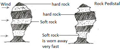
There are rock pedestals in Saudi Arabia, Tibest Mountains in central Sahara and in Niger.
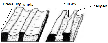
ii. Zeugen
ii. Zeugen
Are the ridge consisted of alternate layers of hard and soft rock overlying vertically downward.
– They are formed in areas where the rock layers lie horizontally and are characterized by joints.
– The weathering process first opens up the joints and then wind abrasion continues the work of weathering leading to the formation of furrows and Zeugen
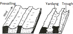
iii. Yardangs
Are the ridges consisted of hard and resistant rock bands standing either vertically or at an angle and can vary in height from 5m to 15m but having lengths of up to 1000m.
The yardangs are parallel to the direction of the prevailing wind. Example: – Yardangs can found near Salah (central Algeria and near Kom Ombo in Egypt.
iv. Blowouts
– Blowouts are also known as Deflation hollows or pans.
These are the hollows or depressions produced by wind deflation.
– The small hollows are known as pans and are common in Kalahari Desert.
– Larger hollows like Qattara Depression in Egypt were formed by wind deflation.
– When these hollows are filled with water oases are formed.

v. Inselbergs
– Are the residual hills consisted of hard and resistant rock left standing on the surface after the rest part of the earth has been eroded
– When inselbergs are smooth and round in shape are called bornardts
– When the inselbergs are characterized by a lot of joints with rectangular rock blocks pilled together to produce a castellated form are called Kopjes

Note: – Inselbergs investigated that, many of them in the desert are formed due to the water action rather than wind action.
vi. Ventifacts
Are heavier rock blocks or pebbles left behind after the wind has sorted and carried away all material.
– They are sharpened and flattened as they lie by the action at the sandblast passing over them

WIND ACTION DEPOSITIONAL FEATURES
The material transported by wind from different features after deposition. The features formed include the following
- Sand Dunes
Are the hills of sand which have been deposited by winds in the desert
The formation of sand dunes is influenced by the extent of vegetation cover, the size of particles amount of the material and velocity of the wind.
There are two main types of sand dunes.
These are
i. Barchans
ii. Seifs
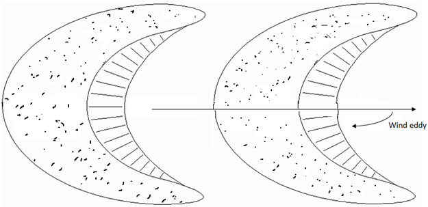
BARCHANS / BARKHANS
Are the crescents – shaped sand dunes which occur individually or in groups.
– Development of barchans is usually influenced by the obstruction which may be a tree or large stone.
– The windward side of the barchans is steep and slightly concave.
SEIF DUNES
– Seif dunes are also known as longitudinal dunes.
– They are long narrow ridge of sand which lies parallel to the direction of the wind.
– They usually occur on the small scale in sandy areas such as along the coasts and in the extensive sides of the river valley but such sand dunes are in small size because of the limited supply of sand.


LOESS
Is the accumulation of the fine particles of sand that have been carried beyond the limit of deserts.
– They are mostly found in loess plateaus of the China.
– The loess leads to the formation of fertile soil
RIPPLES
– Are the smallest wavy structures, sometimes less that a centimeter high.
– They are commonly between the dunes

GLACIATION
Glaciation refers to the process whereby a certain area on the earth’s surface is affected by glaciers (moving ice). Glaciations also refer to the process that takes place due to the influence of moving ice.
Glacial erosion
Glacial erosion, which predominates in the highlands, consists of the following mechanism or processes.
Sapping: This refers to the breaking up of rocks by alternate freezing and thawing of water at the bottom of cracks between a mass of ice and the side and floor a valley, or the
side of a mountain.
side of a mountain.
Plucking: This is the tearing away of the blocks of rock which have been frozen into the sides or bottom of a glacier.
Abrasion: This is the wearing a way of rocks beneath a glacier by the scouring (scrapping) action of the rocks embedded in the glacier.
Feature produced by glacial erosion
Cirque (corrie): A semi-circular, steep-sided basin cut into the side of a mountain, or at the head of a valley. It is formed by the process of plucking, which steepens the basin, and abrasion, which deepens the valley. Some corries contain glacier, but in others the glaciers have melted and they now contain lakes (sometimes called tarns). Examples of tarns are Lake Tana in Ethiopia and Teleki tarn on Mount Kenya.
Arete: A steep-sides, knife-edged separating two cirques. It is formed by the cutting back of the walls of cirques by plucking. Examples of found on Mount Kenya.
Pyramidal peak: A jugged peak with a steep sided, angular horn. It is formed by the steepening of the back walls several cirques which lie on the sides of a mountain. Examples of pyramidal peaks are found in Mountain Elgon.
U-shaped valley: A steep-sided, flat- bottomed, wide valley contains features formed by both glacial erosion and deposition on the foot of the glaciated highland. It is formed by vertical and lateral erosion of moving ice. Most U-shaped valleys were originally river valleys.
Hanging valley: Are tributary valley of a U-shaped valley which ends abruptly, high above the floor of the U-shaped valley and separated from it by an almost vertical slope. It is formed due to unequal down cutting on the tributary valley.
Rock basin: An irregular depression in the floor of a U-shaped valley formed by unequal glacial erosion of the bedrock. It develops when the thickness and weight of a glacier increase, e.g. at the junction of two glaciers. Sometimes a rock basin becomes a lake when the glacier melts.
Ice-eroded plain: An extensive area once covered by an ice sheet which smoothed off the original landforms to give rounded topography, with large area of bare rock scratched boulders embedded in the base of the ice and rock basins in areas of weak rock, and the whole swept almost clean of the original weathered rock.
Roche Mountonnee: An outcrop of resistant rock smoothed by a glacier on the upstream side into a gentle slope. On the downstream side, the glacier eroded by plucking to give steep and jugged slope. It is formed where resistant rocks rise above the surrounding land surface. The upstream side of the rock is plucked to a steep slope.
Crag and tail: A head of resistant rock which protected a weaker rock from ice erosion on the downstream side.
Truncated spurs: These are blunt-ended rock ridges which descend from the steep sides of a U-shaped valley or glacial through. They are often separated by hanging valley.
Before glaciations, relatively immature rivers display a pattern of interlocking spurs. A valley glacier cannot avoid the interlocking spurs as a river can. As the valley glacier moves, abrasion and plucking eroded the protruding tips of the spurs, leaving steep cliff-like truncated spurs.
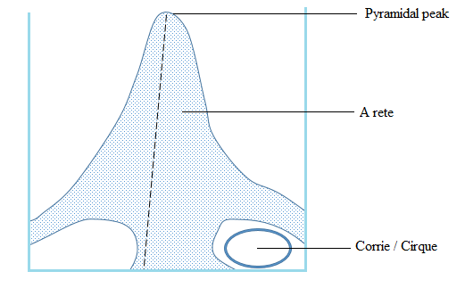


Depositional features of glaciations
Moraine: These are unsorted rock fragment of all sizes, from sand to boulders, formed partly by frost action and partly by glacial abrasion, transported by a glacier and dumped in ridges or sheets.
Types of moraines
A moraine that forms along the sides of a glacier is called lateral moraine; that along the front of the glacier is called terminal moraine and the at the bottom of the glacier is called ground moraine. When two glaciers join, their inner lateral moraines join together and give a medial moraine.

Boulder clay plain: A plain made of clay and boulders, deposited by ice sheets and glaciers over a surface.
Drumlin: Elongated, oval-shaped hill made of boulder clay and about 1 km long and 25 to 100m wide.
Each drumlin is a small hill, tending towards an egg shape, with its steepest slopes and summit at the up-ice end. Drumlins rarely occur singly, however, and are found in groups or swarms, with the tapered end of each hill pointing in the direction of glacier flow.

Eskers: An esker is a long, narrow, winding ridge of stratified sand gravel. The materials that form an esker are deposited by sub-glacier streams which retreat their way in the channel under the ice. Eskers reach up to 40 meters high. They are mostly found in Scandinavian countries.
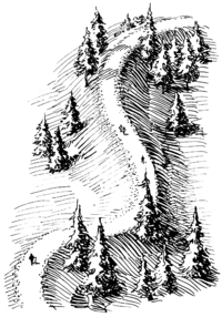
Kame: Is an irregular-shaped mass of stratified material formed as a delta on the surface of a stationary glacier or at its margin. It is a mound-like hill of poorly sorted material mostly sand and gravel, deposited at or near the terminus of a glacier. A kame may be produced either as a delta of a melt water stream or as an accumulation of debris let down onto the ground surface by the melting glacier.

Erratic: A glacial erratic is a piece of rock that differs from the size and type of rock native to the area in which it rests.

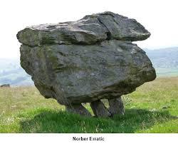
Most erratic can bound at Kimberlay (South Africa), North East USA and Wales in Britain

COASTAL LANDFORMS
A coast is a land or area near the ocean or sea. Coastal zone or line is a part of the coastal land bordering the sea or the part which can be reached by the strongest sea waves. The term is related to the study of the coast.
Definition of terms
Swash: This is the forward movement of waves from the coastline.
Backwash: This is the backward movement of waves from the coastline.
Wave: The upward and downward movement of water following the direction of wind.
Crest: The highest apart of the wave.
Trough: The lowest part of the wave.
Wavelength: The distance from crest to crest or trough to trough.
Wave height (pitch): The distance between the crest the trough. The size of the wave or wave or wavelength depends on the strength of the wind, i.e. the stronger the wind the larger the waves and wavelength, and vice versa.

The coast has various physical features often termed as coastal landforms. These features have been formed due to various factors or changes (natural and manmade) which have affected the coastline or coastal zone. There are different factors for the changes or evolution in the coastline (the factors influencing the development of a coastline). The factors are divided into two groups:
a) Natural factors
This includes the work of ocean waves, currents and tides and agents of erosion, transportation and deposition. For example, the coastline may be affected by marine (wave erosional process forming such features such as cliffs, sea caves, wave-cut platforms, etc) and by marine (wave) deposition forming such features as beach, spit, sand bars etc.
The nature of the coastal rocks, i.e. Whether the coastal rocks are resistance to wave erosion or weathering or not. Where the coastal is resistant to marine erosion and weathering, coastal cliffs and headlands may be formed. Where the coastal rocks are not resistant to marine erosion and weathering, bays and caves will be formed.
The nature of the coastal rocks, i.e. Whether the coastal rocks are resistance to wave erosion or weathering or not. Where the coastal is resistant to marine erosion and weathering, coastal cliffs and headlands may be formed. Where the coastal rocks are not resistant to marine erosion and weathering, bays and caves will be formed.
The trend of the coastline – this refers to the direction and orientation of the coastline in relation to the marine erosional and depositional processes, e.g. steeply sloping coastline may favour the development of marine depositional features such as spits.
The effects of glacier and ice sheets reaching the sea or ocean. These may increase the sea or ocean level and hence lead to the submergence of the coastal areas forming landforms such as fiords (Fjords), and Rias.
Volcanic eruption and earthquakes along the coast. These may from various volcanic coastal features or may cause displacement or faulting of the coastal rocks.
Growth of reefs along the eastern coasts of Tropical Ocean water, e.g. fringing reef, barrier reef, atoll, etc.
Growth of reefs along the eastern coasts of Tropical Ocean water, e.g. fringing reef, barrier reef, atoll, etc.
b) Man-made factors
Through engineering activities such as construction of ports and dredging of estuaries.
Through land reclamations processes of agriculture, settlements or recreation
Through construction of dykes and lifeguard towers.
Through quarrying activities along the coast e.g. quarrying of sand and gravels.
Mining along the coast.
Fishing by using illegal means such as dynamites or explosives. Marine (wave) erosion refers to the coast by waves (current and tides). Processes involved in marine erosion (marine erosion process) are
Abrasion (corrosion) : The erosion of the coastal by the material carried by waves
Chemical solution (corrosion): This occurs where the waves dissolve and erode soluble coastal rocks e.g. limestone.
Hydraulic action of waves: This is the erosion of the coastal rock by the power of water (i.e. water waves)
Attrition: This is the erosion that occurs where the materials carried by waves collide and break into small particles which are the transported by waves.
NB: The above marine erosional processes may occur simultaneously although one process may be more dominant than the others. Marine (wave) erosion occurs where backwash is stronger than swash.
Marine (wave) erosional features (land forms)
Ocean cliff: This is rough, steep sided coastal r
ock facing the sea or ocean. It may be formed due to marine abrasion.
ock facing the sea or ocean. It may be formed due to marine abrasion.
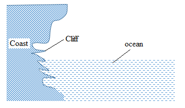
Caves, goes, arches and stocks: These are features produced by wave erosion during the development of cliffs.
Features produced by wave deposition
Beach: This refers to a deposit of mud, sand or pebble on the sea store. A beach has a gently sloping surface, usually formed between low water and high water levels.
Beach
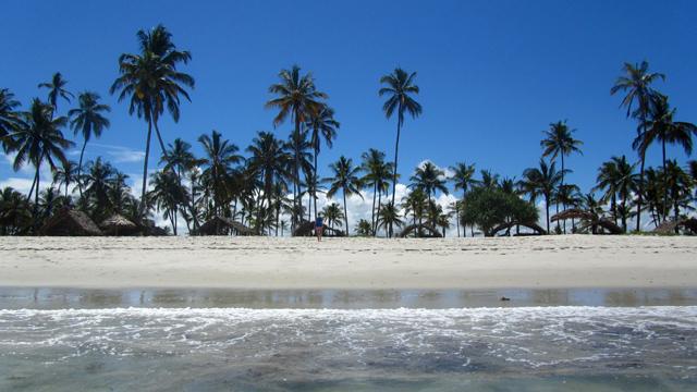
Types of beaches
Storm beach – beach formed by materials (pebbles, stones, mad, sand, etc) deposited by beyond the normal level reached by waves at high tide.
Bay beach – a beach formed by materials deposited at the bay.
Barrier beach – a beach development from an underwater offshore bar as the bar moves towards the land. It is a long ridge of sand, parallel to the coast and separated from it by a lagoon.
Bay beach – a beach formed by materials deposited at the bay.
Barrier beach – a beach development from an underwater offshore bar as the bar moves towards the land. It is a long ridge of sand, parallel to the coast and separated from it by a lagoon.
Spit: Spite is a low, narrow ridge of pebbles or sand joined to the land (mainland or island) at one end, with the other end terminating in sea. It is formed by deposition of material by long shore drift.
Formation of a spit
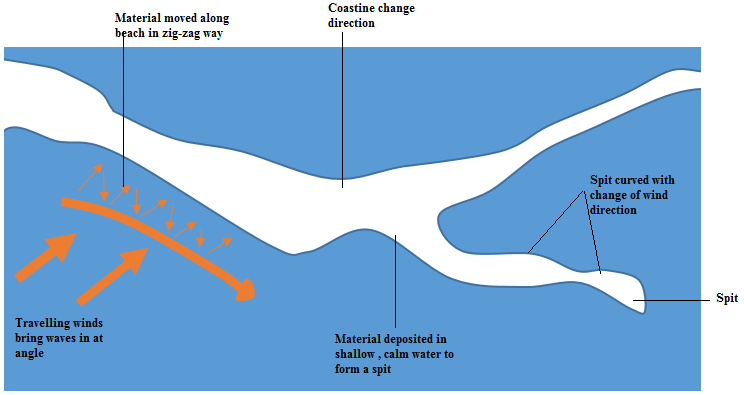
Bar: The words spit and bar are often confused and misused. A bar is a ridge of material, usually sand, which lies parallel, or almost parallel, to the coast. Unlike a spit, a bar is not attached to the land.
Formation of a bar
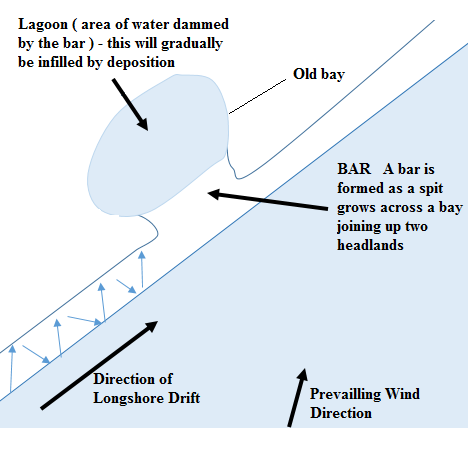
Tombolo: This is a bar that joins an island to the mainland.
Formation of a tombolo
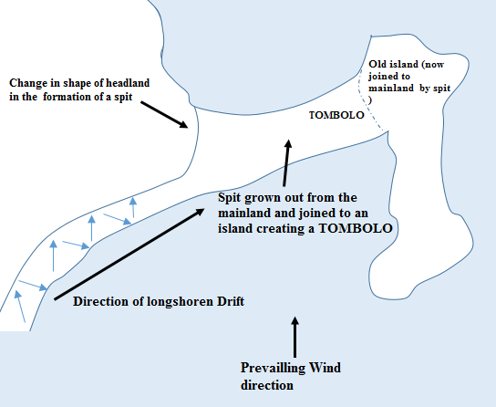
Offshore bar: This is an offshore bar that develops on the gently sloping sea bed, in an offshore zone where sand is thrown up by waves breaking some distance from the coast. The sea waves scoops up sand which is thrown forward where it accumulated as an offshore bar.
Mudflat: This refers to fine silt deposited along gently sloping coasts, especially in bays and estuaries. This deposition of silt, together perhaps with river alluvium, results in the building of a platform of mud called mudflat.

Mudflat.


2 Comments