Share this:
The Earth and the Solar System
Solar system is the group of heavenly bodies comprising the sun and the nine planets.
The origin of the Solar System
Theories
A theory is a set of reasoned ideas intended to explain facts or events
- Passing Star Theory
- A star with a greater gravitational pull passed near the sun
- It attracted large quantities of gaseous materials from the sun
- The materials split, cooled and condensed to form planets
- The planets were set in orbit by the passing star
Weaknesses
- Doesn’t explain the origin of the sun and star.
- Minimal chance of a star approaching another
- Materials would disperse than condense
- Collision Theory
- Star with greater gravitational pull passed near the sun
- It attracted large quantities of gaseous materials
- The materials split into portions
- Large portions collided with smaller ones and swept them to form planets.
The weaknesses are the same as the passing star’s Theory.
- Nebula Clod Theory
- There was a slowly rotating cloud of dust and gas called Nebula
- It cooled and began to contact
- Rotation speed increased and successive rings of gaseous materials were formed.
- The rings condensed to form planets
- The central gaseous material remained as the sun
Evidence
- Rotation and revolution of planets in anticlockwise direction
Weakness
The origin of nebular is not explained.
- Supernova/explosion Theory
- There was a violent explosion of a star.
- A cloud of dust (nebular) remained from the star.
- There was fast movement of the cloud due to the force of explosion.
- Rotation speed increased due to gravitational attraction
- The cloud flattened into a disc.
- The matter began to accumulate towards the centre to form a proto-sun which later began to shine.
- The rest of the cloud collapsed to form planets.
Weaknesses
- Doesn’t explain the origin of the star
- Doesn’t explain the cause of explosion
Composition of the Solar System
1. The Sun
It’s the centre of the universe.
Characteristics
- It’s a star.
A star is a heavenly possessing its own light which it transmits.
Nebula/galaxy is a cluster of stars.
The earth is in a galaxy called The Milky Way.
- It’s made of very hot gases mainly hydrogen (70%) and helium (30%).
- Has a diameter of 1392000km.
- Surrounded by a layer of gas which has boiled from its surface which is called corona.
- Rotates on its own axis in anticlockwise direction.
- Has gravitational pull which holds all the planets in orbit around it.
An orbit is a path which a planet or a satellite follows around a star or a planet.
- Temperature at its centre is 15m◦c and at the surface is 5500◦c.
- Radiates solar energy which is very important for all forms of life on the earth.
2. The Planets
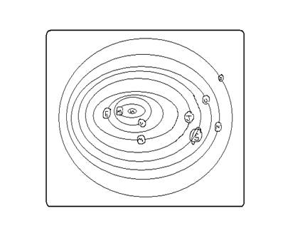
Planets are large spherical celestial/heavenly bodies in space.
There are 9 planets in our solar system.
Characteristics
- Spherical in shape
- Don’t have their own light but reflect it from the sun.
- Revolve around the sun in anticlockwise direction.
- Have their own force of gravity
- Only one is known to support life.
The following are the planets arranged in order from the one nearest to the sun.
Mercury
- Nearest from the sun
- Its 58m km from the sun
- Has no satellites
- Takes approximately 88 earth days to revolve around the sun
Venus
- 2nd planet from the sun
- It’s 108m km from the sun
- One of the brightest planets
- Can be seen clearly with naked eyes
- Takes approximately 225 earth days to revolve around the sun
- Slightly smaller than the earth
- Has no satellites
- Together with the earth they are called twin planets due to having many similarities
Earth
- The 3rd planet from the sun
- The earth and the heavenly bodies make the universe
- The only planet that supports life
- The home of man
- Approximately 149m km from the sun
- Takes 365 ¼ days to revolve around the sun
- Has one satellite, the moon
Mars
- Also called The Red Planet because when it’s observed through a telescope it appears reddish.
- The 4th from the sun
- Slightly smaller than the earth
- Approximately 228m km from the sun
- Takes 687 earth days to revolve around the sun
- Between Mass and Jupiter there are small celestial bodies called planetoids.
- Has no satellite.
Jupiter
- 5th planet from the sun
- Approximately 778m km from the sun
- Largest in the universe
- Rotates on its own axis at very fast speed
- Has flattened poles due to its fast speed of rotation
- Has very thick layers of ice on its surface
- takes 12 earth years to revolve around the sun
- Has 16 satellites
Saturn
- 6th planet from the sun
- Second largest planet
- Approximately 1427m km from the sun
- Takes 29 ½ earth years to revolve around the sun
- Has a ring around it
- Has 18 satellites
Uranus
- 7th planet from the sun
- About 4 times bigger than the earth
- Approximately 2870m km from the sun
- Also rotates very fast
- Also has flattened poles due to fast speed of rotation
- It appears greenish foe being surrounded by methane gas
- Has 8 satellites
- Takes 84 earth years to revolve around the sun
Neptune
- One of the farthest from the sun
- 8th planet from the sun
- Approximately 4497m km from the sun
- Has 8 satellites
- Takes 165 earth years to revolve around the sun
- Very similar in size, colour and character with Uranus
Pluto
- 9th planet from the earth
- Farthest from the sun
- The smallest
- 1/6 the size of the earth
- Approximately 5900m km from the sun
- Takes 248 earth years to revolve around the sun
- Has one satellite
- Very little is known about it
Other Celestial Bodies
Natural Satellites
- Any natural heavenly body that orbits around a planet e.g. moon for earth, tritan for Saturn and Triton for Neptune.
Asteroids/Planetoids
- Also called minor planets.
- Are small fragments of rocks left going around the sun when the solar system was formed
- Found between Mass and Jupiter
- Are 1500 in number
- They sometimes collide with each other and planets due to Jupiter’s gravitational pull causing them to move in erratic orbits.
Comets
- Heavenly bodies which appear to have a head and a long tail
- Made of ice, dust and frozen gas
- The head is made of many particles of dust, rock and frozen gases.
- Their tail is made of gases and points away from the sun.
- Move around the sun in extremely long and oval orbits
- Their orbits cross the earth’s orbits e.g. Halley’s Comet which appears after every 76 years.
Meteoroid
- Small heavenly body which strays from its orbit in the solar system and enters the earth’s atmosphere at very high speed.
Meteor
- A meteoroid which is burning out due to friction after entering the earth’s atmosphere.
Meteorite
- Remains of a meteoroid which have reached the earth’s surface or incompletely burnt up meteoroid.
- When they fall they sink into the ground forming craters
- They are rich in iron
The Moon
- A natural satellite
- Receives its light from the sun and reflects it onto the earth.
- It revolves around the earth
- Takes 29.5 days to complete one revolution around the earth
- Its orbit is almost circular
- As it revolves around the sun it appears in various shapes ranging from crescent/new moon, half moon, gibbons moon and full moon.
- Has gravitational pull which causes the rising and falling of the ocean level
- As the moon orbits around the earth it creates an event called eclipse.
Eclipse
-Phenomenon occurring when the rays of the sun are blocked from reaching the earth or the moon.
Solar/Sun Eclipse

- The moon comes between the earth and the sun
- The moon’s shadow is cast on the earth
- The sun appears to be covered by darkness
Lunar/moon Eclipse
- The earth comes between the moon and the sun
- The earths shadow is cast on the moon
- The moon appears to be covered by darkness
The Origin of the earth
- A star with a greater gravitational pull passed near the sun
- It attracted large quantities of gaseous materials from the sun
- The materials split, cooled and condensed
- Heavier materials collected at the centre to form the core
- Less dense materials collected around the core to form the mantle
- The lightest materials formed the crust
The shape of the earth

The shape of the earth is called geoid/ovoid/oblate spheroid due to being an imperfect sphere by being wide at the equator and flat at the poles.
Proofs/Evidence That the Earth Is Spherical
- If one moves towards the east in a straight line he will end up where he started.
- Satellite photographs taken from space show that the earth is like a sphere.
- Places in the east see the sun earlier than those in the west.
- When a ship is approaching the smoke is seen first, then the mast and finally the whole ship.
- All the planets are spherical so the earth being one of them is also spherical.
- During the moon eclipse the earth casts a spherical shadow on the moon.
- The earth’s horizon appears curved when observed from a very high point like a tower.
The size of the earth
- Equatorial diameter-12756km
- Equatorial circumference-40085km
- Polar diameter-39995km
- Surface area of the earth-510×106 km2
- Water surface-73%.
The Movement of the Earth
There are 2 movements of the earth namely:
- Rotation of the earth on its axis
- Revolution of the earth around the sun
Rotation of the Earth
-Movement of the earth on its own axis (imaginary line through the centre from N pole to S pole.
- Rotates through 360◦.
- Takes 24 hours (day) to complete 1 rotation.
- Rotates in an anticlockwise direction (west to east).
Effects of Rotation of the Earth
- Creates day and night because at any one time one side of the earth faces the sun (day) and the other remains in darkness (night).
- Causes deflection of winds and ocean currents in the N hemisphere to the left and in the S hemisphere to the right.
- It causes rising and falling of ocean tides.
- Causes time difference between longitudes.
- Takes one hour to go through 15◦.
- 4 min to go through 1◦.
Calculation of Local Time
-The time recorded in places within the same longitude.
A longitude is an imaginary line running from N to S which shows how far E or W a place is from the prime meridian.
Greenwich Meridian (0◦) longitude is the point of reference when calculating time.
Time is gained towards the E and lost towards the W.
Examples
- Suppose the time at GWM is 12 noon what is the local time at Watamu 40◦E?
Time gained=40×4=160min=2 hours 40min
Local time at Watamu is 12.00+2.40=14.40-1200=2.40pm.
- At Dar-es-Salaam 40◦E time is 12pm what is the time at Ecuador 40◦E?
40◦+20◦=60◦
60×4=240min=4hours
Ecuador is behind in time =12.00-4=8 am.
If the places are on the same side subtract the degrees to get the difference and add or subtract from the reference time depending on which side the place is.
Calculation of Longitude
What is the longitude of place x whose local time is 8 am when local time at GWM is noon?
Time difference =12.00-8=4 hours
Degrees=4×15=60◦
Since x is behind in time its then 60◦W.
Standard Time and Zones
- Standard time is time recorded by countries within the same time zone.
- Standard time was come up with due to confusion resulting from time changing at every longitude.
- The world has 24 time zones.
The International Date Line
It’s the 180◦ longitude.
Effects of Crossing It
- One gains time when he crosses it from W to E and has to adjust the clock ahead by 24 hours.
- One loses time when he crosses it from E to W and has to adjust the clock backwards by 24 hours.
Revolution of the Earth
- Movement of the earth in its orbit around the sun.
- It’s in anticlockwise direction.
- The orbit of the earth’s revolution is elliptical.
- Takes 365 ¼ days in a year or 366 days in a leap year (every 4 years).
- The sun moves from the tropic of cancer to the equator and then towards tropic of Capricorn and back to the tropic of cancer.
- 21st march and 23rd September are called equinoxes because
the length of day and night is equal. The sun is vertically overhead at noon at the equator. - 21st June is called summer solstice because its summer in the N hemisphere. The sun is vertically overhead at noon at the tropic of cancer.
- 22nd December is called winter
solstice because its winter in the S. hemisphere. The sun is vertically overhead at noon at noon at the tropic of Capricorn. - Solstice is the period of maximum tilting of the earth towards the sun.

Effects of the Revolution of the earth
- Causes the four seasons summer, autumn, winter and spring due to the movement of overhead sun causing changes in the heat belt.
- Causes variation of day and night’s lengths due to the earth’s axis being inclined to the path of revolution at an angle of 60◦.
- Equinoxes have equal lengths of day and night.
- Summers have longer days and shorter nights.
- Winters have longer nights and shorter days.

- Causes changes in the altitude of the midday sun due to the earth’s orbit being elliptical.
- Highest altitude during equinox
- Lowest altitude during solstices
- Causes lunar eclipse due to revolution bringing the earth in line with the sun and the moon.
The Structure of the Earth

Internal Structure of the Earth
The evidence used to study the earth’s interior are
- mining
- drilling
- quarrying/excavation
A. Crust/Lithosphere
- Outermost layer of the earth
- Made of soils and other loose deposits of sand
- The dominant rocks are granites.
- Extends 0-50km
- Has 2 layers
1. Sial
- Also called continental crust
- Made of light coloured rocks
- Called sial because it’s made up of silica and aluminium.
2. Sima
- Also called oceanic crust
- Mainly made of basaltic rocks which are brittle.
- Called sima because it is made of silica magnesium and iron.
Mohorovicic Discontinuity (Moho)
- A definite zone of discontinuity between the crust and the mantle.
- Was discovered by Dr. Andrija Mohorovicic in 1909.
B. The Mantle/Asthenosphere
- Layer lying between the crust and the core
- Made of iron and magnesium
- Has two layers
- Upper mantle
- Rocks are more elastic than those of sima.
- Temperature is about 1000◦c.
- lower mantle
- Rocks are like very viscous liquid.
- Temperature ranges between 1000◦c to 3000◦c.
Why the Interior of Earth Is Very Hot
- Due radio-active decay causing most of the heating.
- Due to great pressure as a result of overlying crustal materials.
- The original heat resulting from slow cooling of the materials which were pulled off the sun
Gutenberg Discontinuity
- A definite zone of discontinuity between mantle and core.
C. Core/barysphere/Centrosphere
- The innermost/central layer of the earth.
- Has 2 layers
Outer Core
- Composed of very dense rocks
- Made up of nickel and iron
- Temperatures are up to 3700◦c.
Inner Core
- A solid mass of mainly iron
- Temperatures are estimated to be 4500◦c to 5000◦c.
External Structure of the Earth
- The Atmosphere
- Layer of gases surrounding the earth.
- The earth revolves with it because its held onto it by gravity
- It’s about 330km thick.
Composition of the Atmosphere
- Gases-exist as a mixture
- Smoke particles
- Dust particles
- Water vapour
The structure of the Atmosphere
It’s divided into 4 layers/zones namely:
- Troposphere
Lowest layer of the atmosphere
Contains 90% of water vapour
Rainfall is got from it
Temperature decreases with increase in altitude (lapse rate)
Air is turbulent due to mixing of air
Contains dust particles
There is a zone of transition between troposphere and stratosphere called tropopause.
- Stratosphere/ozonosphere
Layer lying next to troposphere
Has layers
Lower isothermal layer in which temperature is constant
Upper layer of temperature inversion in which temperature increases with increasing altitude
Has ozone layer which absorbs harmful ultraviolet radiation.
Air is calm so its used by passenger jets
Limited amounts of water vapour
There is a zone of transition between stratosphere and mesosphere called stratopause.
- Mesosphere
Middle layer of the atmosphere.
Temperature decreases with increasing altitude.
There is a zone of transition between mesosphere and thermosphere called mesopause which is an inversion layer.
- Thermosphere/ionosphere
- High radiation is present.
- The pressure is very low.
- Gases and molecules in this layer exist as ions due to high radiation.
- Has no definite top but merges gradually into the outermost part of the atmosphere called exosphere.
- Exosphere consists of rare gases like hydrogen and helium.
- Beyond the atmosphere there is the outer space.
- Outer space is the universe beyond the atmosphere in which other planets and stars exist.
Significance of Atmosphere
- Animals and plants breathe in from it oxygen for respiration.
- Plants use carbon dioxide from it for photosynthesis.
- Water vapour in the atmosphere condenses to form clouds which give us rain.
- Ozone layer in the stratosphere shields us from ultraviolet radiation which may cause cancers.
- Carbon dioxide and methane in the atmosphere cause global warming through the green house effect.
b) The Hydrosphere
- Part of the earth’s surface covered by water masses e.g. oceans, seas, lakes, rivers and even underground water.
- It comprises 73% of the earth’s surface area.
- The atmosphere and hydrosphere are related in that atmospheric gases penetrate to the ocean depth in solution form.
- The lower atmosphere, hydrosphere and the upper part of the earths crust are called biosphere meaning the sphere of the earth in which organic life exists.
WEATHER
–Daily atmospheric conditions of a place at a particular time.
Elements of Weather
- Temperature
- Humidity precipitation
- Precipitation
- Atmospheric pressure
- Wind
- Sunshine
- Cloud cover
A Weather Station
–A place where observation, measuring and recording of weather elements is done
Factors to Be Taken Into Account When Sitting a Weather Station
- An open place where there is little obstruction of weather elements.
- Accessible place so that recording can be done easily.
- A fairly level or gently sloping ground (5◦) so that it’s easy to position weather instruments.
- The place should provide a wide view of the surrounding landscape and the sky.
- The site should be free from flooding.
- The place should have security.
Instruments for Measuring Elements of Weather
- Thermometer-temperature
- Hygrometer-humidity
- Rain gauge-rainfall
- Barometer-air pressure
- Sunshine recorder-sunshine duration and intensity
- Wind vane –wind direction
- Anemometer-wind speed
- Evaporimeter-rate and amount of evaporation.
The Stevenson Screen

-A white wooden box mounted on 4 legs used to house thermometers and hygrometers.
The instruments which are found in it are:
- Maximum thermometer
- minimum thermometer
- Six’s thermometer
- hygrometer-wet bulb and dry bulb thermometer
Importance
- Provide shade conditions for accurate temperature recording.
- Ensure safety of thermometers because they are delicate.
Qualifications Which Make Stevenson Screen Suitable For Its Work
- Painted white for little absorption of solar heat energy.
- Made of wood which is a bad conductor of heat.
- Well ventilated to allow easier flow of air inside it.
- Raised to prevent contact with terrestrial radiation.
- Has double roof which acts as an insulator to prevent direct heating from the sun.
Recording and Calculating Weather Conditions
Temperature
-Degree of hotness of an object or a place.
It’s measured using 3 types of thermometers namely:
- Maximum thermometer
- Minimum thermometer
- Six’s thermometer
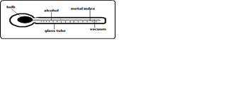
Maximum Thermometer

It’s used to measure the highest temperature reached in a day.
It uses mercury.
How It’s Used/Works
- Temperature rises causing mercury to expand.
- Mercury pushes the index up.
- When temperature falls mercury contracts.
- The maximum temperature is read from the scale at the lower end of the index.
- Thermometer is reset by shaking it to force mercury back into the bulb.
Minimum Thermometer
It’s used to record the lowest temperature reached in a day.
It uses alcohol.
How it’s Used/Works
- Temperature falls causing alcohol to contract.
- Alcohol pulls the index down.
- When temperature rises alcohol expands and rises in the tube.
- The index remains where it was pulled.
- Minimum temperature reading is obtained from the scale at the lower end of the index.
Calculating Temperature
- Diurnal/daily Temperature range
–Difference between the maximum and minimum temperature for any one day.
- Mean Daily Temperature
–Average of the maximum and the minimum daily temperatures.
- Mean Monthly temperature
-Sum of mean daily temperatures in a month divided by the number of days in that month.
- Mean Monthly minimum Temperature
–Sum of daily minimum temperatures divided by the number of days in that month.
- Mean Monthly Maximum Temperature
-Sum of daily maximum temperatures divided by the number of days in that month.
- Mean Annual Temperature
-Sum of mean monthly temperatures divided by 12.
- Mean Annual Temperature Range
–Difference between the highest and the lowest mean monthly temperatures in a year.
- ◦k=◦c+273
- ◦F=(◦c×1.8)+32 derive the rest from the formulas.
Rainfall

Rain gauge is the instrument used to measure the amount of rainfall in a day.
It should be made of impermeable material which can’t absorb water.
How It’s Used/Works
- It’s taken to an open space to prevent water from dropping into the funnel.
- Its sunk into the ground to prevent evaporation
- The funnel top is left 30cm above the ground to prevent splashes of water and run off.
- After 24 hours water is emptied into the measuring cylinder.
- The reading of the amount of rainfall is got from the measuring cylinder in millimetres.
- The figure represents the millimetres of water falling on each square millimetre of the ground.
- It could be used to measure snow fall by melting it before the readings are gotten.
Calculating Rainfall
- Monthly Rainfall Total
–Sum of rainfall recorded in a month.
- Annual Rainfall Total
-Sum of monthly rainfall totals for 12 months.
- Mean Monthly Rainfall
-Sum of rainfall totals for a particular month over several years divided by the number of the years of observation.
- Mean Annual Rainfall
-Sum of mean monthly rainfall for 12 months of the year.
Sunshine

Duration of sunshine is measured using Campbell stokes sunshine recorder.
How It Works
- Spherical lens focuses light on sensitized paper.
- The paper burns when the sun is shining.
- The total hours of sunshine is got by adding all the burnt sections from calibrations on the side of sensitized paper.
- The sensitized paper is changed every day.
Humidity
Humidity is the condition of atmosphere with reference to its water content.
It’s measured with hygrometer or psychrometer which consists of wet and dry bulb thermometers kept in Stevenson screen.
Dry bulb thermometer is a thermometer covered with muslin bag immersed in water while dry bulb thermometer has no muslin.
How It Works
- When air is dry there is a lot of evaporation from the muslin.
- Evaporation cools the bulb of thermometer resulting in a low temperature reading.
- When humidity is high there is little evaporation from the muslin.
- The wet bulb thermometer is cooled at a slower rate and both thermometers show almost the same temperature reading.
- The difference in readings between the two thermometers is used to determine relative humidity.

Interpretation of Hygrometer Readings
- When the 2 readings are the same, relative humidity is 100% i.e. the air is saturated.
- If the difference is small, humidity is high.
- If the difference is big, humidity is very low.
Calculating Humidity
Absolute Humidity
-Actual amount of water vapour a given volume of air can hold. It’s expressed in g/m3.
Specific Humidity
-Mass of water vapour in a given mass of air. It’s expressed in g/km.
Relative Humidity
-Ratio between the absolute humidity and the maximum amount of water the air can hold expressed in a percentage.
R.H.=A.H/Maximum amount of water the air can hold at the same temperature.
Example
- If the air at 20◦c contains 10g/m3 and given air can hold a maximum of 20g/m3.calculate the relative humidity.
10×100/20=50%
Wind
Direction

Wind direction is determined using wind vane.
How It Works
- As the wind blows the arrow swings.
- The arrow points in the opposite direction of the wind flow.
- The direction is read from the cardinal compass points.
- The arrow will point in the direction from which the wind is blowing.
- For instance if it points S the wind is blowing from S towards N.
Wind Sock

-Used to indicate the general direction of wind flow.
-Not kept in a weather station because it doesn’t give the accurate direction of wind flow.
-Seen near airstrips for the benefit of pilots.
How it Works
- When wind blows the bas stretches out in the direction that the wind is blowing.
Wind speed/Velocity

–Measured using anemometer.
How It Works
- When wind bows hemispherical cups rotate.
- The number of rotations is obtained from the metre on the lower part of the anemometer.
- The units for measuring wind are called knots.
Atmospheric Pressure
–The force exerted by gases in the atmosphere on some area or body on the earths surface.
-Measured using barometers of three types namely mercury, aneroid and Fortin Barometers.
Mercury Barometer

How It Works
- Air exerts pressure on the mercury in the beaker.
- The height of mercury in the tube is proportional to the atmospheric pressure.
- The readings are taken in mmHg.
- Its 760mmHg at sea level
Advantage
Quite accurate
Disadvantage
- Cumbersome to carry around.
- Can be damaged quite easily while being carried around.
Aneroid Barometer
–Measures changes in atmospheric pressure.
How It Works
- Has air tight compartment (vacuum).
- Compartment expands when pressure decreases.
- It collapses when pressure increases.
- The movement is transmitted by lever to a pointer on a dial.
- The readings are in kg/cm3.
Evaporation
The rate and amount of evaporation is measured using piche and tank evaporimeters.
Piche Evaporimeter

- When there is a lot of sunshine water evaporates from the blotting paper.
- The level of water in the glass tube reduces.
- The rate and amount of evaporation is got by looking at the scale on the outside of the glass tube.
- The units are in mm.
Tank Evaporimeter

How It Works
- The tank with water is put in the open.
- Water evaporates when there is a lot of sunshine.
- Water in the tank reduces.
- The rate and amount of evaporation is got from calibrations in the inner side of the tank in mm.
Cloud Cover
The amount of cloud cover is observed using eyes.
It’s given in oktas.
Okta=approximately 1/8 of sky is covered with clouds.
Weather Forecasting
-Prediction of the conditions of the atmosphere for a given place for a certain period.
Methods of Weather Forecasting
Traditional Methods
-Prediction of weather based on traditional beliefs and facts.
- Plants shedding leaves indicates period of drought.
- Safari ants indicate it will rain.
- Migration of butterflies also indicates it will rain.
- Croaking of frogs during dry season indicate its going to rain.
- Flowering of certain plants indicates the onset of rainfall.
- Changes in the intensity of sunshine indicate its going to rain.
Modern Methods
–Prediction of weather using modern instruments and new technology of collecting, transmitting, processing and analysing weather data.
Instruments Used
- Satellites-electronic devices which orbit the earth which collect and transmit weather data which is interpreted by computers.
- Radar-an instrument used to see cloud formation.
- Sensors/radiosodes-instrument fixed on a balloon used to measure atmospheric pressure, temperature and humidity.
- Computers-electronic device used to store, analyse and display weather information.
Significance/Importance of Weather Forecasting
- Helps us to be aware of natural calamities related to weather before they occur so as to take precautionary measures.
- Guiding tourists on when to visit national parks.
- Helps farmers to plan their activities such as planting, harvesting, etc.
- Ensures air and water transport is carried out safely.
- Helps sporting people to plan their training and competition schedules.
- Helps people to plan many other activities such as mining, electricity generation, holiday events, etc.
- Helps fishing communities to plan their activities.
Factors Hindering Weather Forecasting
- Lack of skilled man power due to limited training facilities.
- Lack of modern equipment leading to wrong forecasts.
- Natural calamities such as storms and earthquakes.
- Extreme weather conditions which may damage or displace instruments.
- Use of faulty instruments.
- Human error.
- Poor sitting of instruments.
Factors Influencing Weather
Temperature
Factors influencing temperature
- Altitude
–Height above sea level.
- Temperature decreases with increase in height due to air at higher altitude being thinner and hence there is less particles e.g. gases, dust, smoke and water vapour to store heat so its rapidly lost to the outer space.
- Latitude
-Distance from the equator.
Temperature decreases with increase in latitude.
- Places neat equator experience high temperature due to the rays of the sun travelling a shorter distance facing less interference from atmospheric conditions hence more solar energy reaches the earths surface. Also the rays of the sun strike the earth at right angles hence solar energy is concentrated over a small area.
- At higher latitudes the rays of the sun travel a longer distance facing more interference from atmospheric conditions hence less solar energy reaches the earth’s surface. Also the rays of the sun strike the earth at an acute angle hence solar energy is spread over a large area.
- Aspect
-Direction of slope.
- At higher latitudes slopes facing the equator have higher temperature because they face the sun while those facing the poles have lower temperature have lower temperature because they face away from the sun.
- Winds
–Transfer heat from one place to another.
- When they blow from cool areas they take the cooling effect to the areas they blow over and when they blow from warm areas they take warming influence to the places they blow over.
- Distance from a Large Water Body
- Areas near a large water body experience lower temperature during the hot season and higher temperature during the cool season due to sea breezes, warm and cold ocean currents and wind blowing over water which could be either warmer or cooler than the adjacent land.
- Cloud Cover
- Clouds reduce the amount of solar energy reaching the surface by absorbing, scattering and reflecting solar radiation.
- When there are clear skies during the day the temperature is higher due to the earth receiving maximum solar insolation.
- During clear nights there are very low temperatures due to a lot of terrestrial radiation being lost to the outer space.
- Cloudy nights on the other hand are warmer due to clouds radiating to the earth heat absorbed during the day.
- Length of Day
- The longer the period of solar insolation the greater the quantity of radiation a place receives and hence the more the heat that will be generated by the earth and vice versa.
- Solar Altitude
- At equinox when the earth is farthest from the sun the temperature on the earth is lower due to less solar radiation reaching the earth’s surface due to travelling a longer distance and hence facing great interference from atmospheric conditions.
- At solstices the earth receives more solar energy due to travelling a shorter distance and hence facing less interference from atmospheric conditions.
- Solar Input
- Sometimes the sun gives out more heat due to reactions being violent causing temperature on the earth to be higher.
- When it gives out less heat the temperature on the earth is lower.
- Surface Conditions
- Light surfaces e.g. smooth surfaces reflect sunlight and hence less solar energy reaches the earth’s surface.
- Dark and irregular surfaces such as with vegetation absorb more heat leading to higher surface temperatures.
Humidity
Factors Influencing Humidity
- Temperature
- Places with high temperature experience high humidity due to high evaporation and air having high capacity to hold moisture.
- Places with low temperature have low humidity due to low evaporation and air having low capacity to hold moisture.
- Source of Moisture
- Areas near water bodies e.g. Kisumu and Mombasa experience high humidity due to evaporation of water from the water body.
- Places near thick vegetation also have high humidity due to evapotranspiration.
- Areas far away from water bodies such as the middle of deserts have low humidity.
- Areas receiving heavy rainfall also have high humidity.
- Air Pressure
- There is high humidity at low altitudes because high pressure compresses air warming it increasing its capacity to hold moisture and also causes high evaporation.
- There is low pressure at high altitudes because air expands and cools thus reducing its capacity to hold moisture.
- Latitude
- Low latitudes experience high humidity due to high temperatures resulting into high rates of evaporation and air having high capacity to hold moisture.
- High latitudes experience low humidity due to low temperatures resulting into low rates of evaporation and air having low capacity to hold moisture.
Significance of Humidity/Moisture
- Affects rain formation in such as way that places with high humidity are likely to experience higher rainfall than those with low humidity.
- Regulates the heat loss from the earth’s surface by absorbing terrestrial radiation (process in which the earth gives off heat into the atmosphere).
- It affects sensible temperature in that the higher the humidity the more we experience sensible temperature.
Precipitation
-The forms in which the earth’s surface receives moisture.
- Snow
Solid precipitation formed when tiny water droplets freeze and form ice crystals.
The crystals may fuse to form flakes.
- Sleet
-Precipitation which is a mixture of rain and snow.
- Hail
Roughly spherical lumps of ice formed when super cooled cloud droplets mould themselves around ice crystals before cooling. It destroys crops life and house roofs.
- Dew
-Precipitation consisting of water droplets formed on cold surfaces at night e.g. iron roofs and glass blades.
How It’s Formed
- In a clear night there is a high ground radiation.
- Temperature of the earth’s surface fall below dew point (temperature at which air being cooled becomes saturated).
- Excess water condenses on cold surfaces.
- rain
-Precipitation consisting of water drops/droplets formed when tiny water droplets merge around particles of matter and become heavy and fall down to the earth.
Condensation
Turning of water vapour into tiny water droplets as cooling continues below dew point.
The droplets join to form clouds.
Causes of Condensation
- Adiabatic cooling-cooling of moist air as it rises vertically.
- Orographic cooling-cooling of moist air as it climbs a hill or mountain.
- Frontal cooling-cooling of warm air mass when it blows towards a cold air mass.
- Advection cooling-cooling as a result of moist air moving over a cool land or sea.
How Condensation Takes Place/Cloud Formation
- Moist air rises to the condensation level (altitude where temperature is below dew point.
- It’s cooled below dew point.
- Tiny water droplets condense around tiny particles such as dust, smoke particles and pollen grains and salt particles (condensation nuclei).
- The droplets merge and eventually become bigger and fall as rain.
- If moisture rises to an altitude where temperature is below 0◦c the condensed water droplets freeze forming ice particles or super cooled water (water which has remained in a liquid state at temperatures below freezing point due to lack of sufficient condensation nuclei.
- Super cooled cloud droplets may mould themselves around ice crystals before freezing to form hail.
Types of rainfall
- Relief/Orographic/Mountain rainfall

Rain experienced on the windward slopes of mountains or hills formed when moist air is forced to rise over a mountain or a hill.
How it Forms
- Moist air is forced to rise over a hill or mountain.
- The temperature and air pressure decreases making it to expand.
- Air cools due to decreased temperature and decreased pressure causing it to expand.
- Moisture condenses forming tiny water droplets (clouds).
- The tiny water droplets in clouds merge and become too heavy to be suspended in air and fall as rain.
- Air proceeds to the leeward side with low moisture content.
- Since its heavier due to being cool it descends over that side and gets warmed making it to hold onto the little moisture it had causing that side to receive low rainfall (rain shadow).
- Convectional Rainfall

Type of rainfall common near large water bodies formed as a result of convective rising and cooling of moist air.
It’s accompanied by thunderstorms.
How it forms
- Ground or water body is heated causing evaporation.
- There is convective rising and cooling of moist air.
- Condensation takes place forming tiny water droplets (clouds).
- The droplets merge and fall as rain.
- The cooled dry air descends to the surface where its heated and its capacity to hold moisture is increased.
- The process is repeated.
- Frontal/Cyclonic Rainfall

Type of rainfall common in mid-latitudes formed when warm air blows towards a cold area or when warm air mass meets with a cold air mass.
It’s accompanied by cyclones (violent winds).
How it Forms
- Warm moist air mass meets with a cold air mass.
- The warm air is forced to rise as it’s less dense.
- It cools as it rises at the line of contact with cold air.
- The moisture condenses forming clouds resulting in frontal rain.
Factors Influencing Rainfall Types and Amounts
- Relief/Topography
Relief features such as mountains and hills results in the rising and cooling of moist winds to form relief rainfall.
- Aspect
Windward slopes which are on the path of rain bearing winds receive heavier rainfall than leeward slopes which face away.
- Forests and Water Bodies
Areas near forests and large water bodies experience higher rainfall and more often due to high rate of evaporation.
- air pressure
High pressure areas receive low rainfall than low pressure areas due to pushing of air masses from high pressure to low pressure. The high pressure areas have descending dry air.
- air masses
When warm and cold air masses meet frontal rainfall is formed.
- Ocean Currents
- It influences rainfall whereby coasts washed by warm ocean currents experience heavy rainfall when moist onshore winds are warmed by the current and made to hold on to moisture which they release on reaching the land.
- The coasts washed by cold ocean currents on the other hand experience low rainfall as a result of moist winds being cooled and moisture in them condensed resulting in rain falling over the ocean thereby bringing little or no rain to the coastal areas. This is the cause of western margin deserts e.g. Kalahari and Namib deserts.
Atmospheric pressure
Factors Influencing Atmospheric Pressure
- Altitude
- Pressure decreases with increase in altitude because the column of air becomes shorter hence it exerts less weight.
- Temperature
- When air is heated it expands and exerts pressure over a large area resulting in reduced pressure.
- When it’s cooled it contracts and exerts pressure over a small area resulting in increased pressure.
- Rotation of the earth
- Rotation pushes air masses from poles towards the equator causing air to spread out and occupy more space causing it to expand making pressure to decrease.
- When air from the equator moves towards the poles it occupies less space causing it to contract resulting into high pressure.
Mist and Fog
Mist and fog are a mass of tiny water droplets suspended in the lower layers of the atmosphere.
Fog is denser than mist i.e. has more moisture.
Both hinder visibility although fog reduces visibility to less than a kilometre.
When fog mixes with smoke its called smog.
How They Form
- Moist air cools below dew point.
- Condensation takes place.
- The resultant water droplets remain suspended in the air.
Types of Fog
- Radiation Fog
- Type formed when moist air is cooled below dew point as a result of intense radiation on the ground at night.
- Advection Fog
- Type formed when moist air from the sea moves horizontally over a cold surface e.g. snow covered ground.
- Orographic/Hill/Upslope Fog
- Type formed when moist air is cooled after climbing a hill or mountain.
- Evaporation Fog
- Type formed when water vapour is added to cold air that is already near saturation causing excess water vapour to condense and form fog.
- Frontal Fog
- Type formed when warm moist air is cooled from below as it rises over a cold air mass.
- Steam Fog
- Type formed when moist air passes over the surface of a much warmer fresh water body.
- The warm water is cooled from above and condensing water vapour forms fog. It appears to be steaming.
- Ice Fog
- Type formed when water vapour is converted directly into ice crystals when temperatures are below freezing point.
Clouds
-Are a mass of tiny droplets or ice particles formed when water vapour condenses.
Three Cloud Forms
- Cirroform
-Thin and wispy clouds composed of ice crystals.
- stratiform
-Appear as greyish sheets covering most of the sky and are rarely broken into units.
- Cumuliform
-Are massive rounded with a flat base and limited horizontal extent and billow upwards to great heights.
Basic Cloud Types
- Stratus Clouds
-Are found in layers, are flat in shape and resemble fog.
- Nimbus Clouds
-are dark at the base and sometimes white at the sides and cause rain and thunderstorms.
- Cirro-cumulus
-Are white clouds consisting of white ice crystals.
- Nimbostratus
-A rain cloud which is dark grey and spreads over the sky in low uniform layers.
- Cumulus Clouds
-Clouds with a flat horizontal base, massive, rounded and less horizontal extent.
- Alto cumulus
-High clouds composed of ice crystals which indicate fair weather.
World distribution of Pressure Zones and the Planetary wind System/World Prevailing Winds
The Equatorial Low pressure Zone (ITCZ-low)
- Found between 23 ½ ◦N and 23 ◦N
- Experiences high temperatures.
- A zone of low pressure and doldrums (light and intermediate winds).
- Zone where S.E and N.E Trade Winds converge.
- Associated with convectional rain and thunderstorms.
- Migrates to the N and with the apparent movement of the overhead sun.
The Sub-tropical High Pressure Zone
- Found within 30◦N and 30◦S.
- A zone of high pressure.
- A region of calm descending air.
- Source of Trade Winds and Westeries.
- Zone of divergence of T. Winds and Westeries.
The Temperate Low Pressure Zone
- Found within 60◦N and 60◦S.
- A low pressure zone.
- Zone of convergence of westeries and polar easteries.

The Polar High Pressure Zone
- Found over the poles 90◦N and 90◦S.
- A high pressure Zone.
- Zone of descending calm air of low temperature.
- Source of polar easteries.
The Worlds Prevailing Winds
These are the major winds blowing over the earth frequently and consistently and which influence the world weather.
- Trade Winds
- Blow from sub-tropical high pressure zone and blow to the equatorial low pressure belt.
- Westeries
- Originate from sub-tropical high pressure zone and blow to the temperate low pressure belt.
- The Polar Easteries
- Originate from polar high pressure zone and blow to temperate low pressure zone.
Monsoon Winds
- Seasonal winds which reverse in the direction of flow.
- They blow towards the land during summer (onshore) and from the land during winter (off shore).
- Bring heavy rains when onshore which can cause severe flooding.
- Well developed in the Indian Sun-continent, china, Japan and S.E Asia.
Air Masses
-Distinct large parcels of air moving in one direction
-Originate from areas of uniform weather and topography from where they derive their characteristics e.g. flat areas, forests, deserts, and snow covered areas.
Characteristics of Air Masses
- A large volume of air.
- Covers an extensive area.
- Has uniform temperature and humidity.
- Distinct from the surrounding air.
- Retains its characteristics when it moves away.
Types of air Masses
- Equatorial Air Mass
- Originate from equatorial oceans.
- It’s hot and unstable.
- Sub-tropical Air Mass
- Forms near sub-tropical high pressure belt.
- Polar Air Mass
- Forms near the poles or temperate low pressure zone.
- It’s cool.
- Arctic and Antarctic air Masses
- Forms over the ice sheets of Greenland and Antarctica respectively.
- Effect of air masses on Weather
- When warm moist air mass and cool air mass meet cyclonic rainfall is formed e.g. tropical maritime and polar maritime.
- Cool air masses take cooling effect to the areas they move to e.g. polar continental.
- If they are warm they take warming influence to the area they move to e.g. tropical continental.
Pressure Systems in the World
- Cyclone

- It’s a low pressure system characterised by low pressure at the centre and increases outwards.
- Starts in areas where air ascends from the ground to the atmosphere and descends at high altitude.
- It’s of two types. Tropical cyclones e.g. hurricane, typhoon and willy willies and depressions which are characterised by temperate latitudes.
- The movement of wind is anticlockwise in the N. hemisphere and clockwise in the S. hemisphere.
- Anticyclone
- A high pressure system characterised by high pressure at the centre and decreases outwards.

- It starts in areas where air is descending from the atmosphere onto the ground and then blows outwards on the ground.
- The movement of wind is clockwise in the N. hemisphere and anticlockwise in the S. hemisphere.
Local Winds
–Which occur regularly for a short period of time affecting a limited area.
-Modify the weather of the area they blow to.
1. Sea Breeze

–A light and gentle wind which blows from the sea to the adjacent land.
How it Forms
- During the day land is heated faster than the sea.
- Air over the land is warmed and rises.
- Air from the sea moves to the land to replace the rising air.
- The rising air from the land cools and descends over the sea at high altitude.
- Circulation continues until the pressure difference is reversed at night.
Effects on weather
It takes cooling effect on land on a hot afternoon.
2. Land Breeze
-A light and gentle wind which blows from land to the sea during the night.
How it Forms

- At night land loses heat faster than the sea.
- Air over the sea is warmed and rises.
- Air from the land moves to the sea to replace the rising air.
- Rising air from the sea descends over land at high altitude.
- Circulation continues until pressure difference is reversed during the day.
Effects on weather
It causes early morning showers through moisture brought towards land at high altitude.
- Anabatic winds (Valley Breeze)

-Cool local winds which blow from the valley to the hill tops during summer afternoons.
How it Forms
- During the day hill tops are heated more than valley bottoms.
- Air over the hill tops is warmed and rises.
- Cool air over the valley move up to the hill to replace the rising air.
Effect on weather
-Cause afternoon showers on hilly grounds.
- Katabatic/Descending Winds

-Cold local winds which blow from hill tops to the valley during the night.
- During the night hill tops lose heat faster than the valley.
- Air over the valley is warmed and rises.
- Cool air over the hill tops move to the valley by gravity to replace the rising air.
Effect on Weather
–Takes chilly conditions on valley bottoms.
- Harmattan Winds
-N.E winds which originate from Sahara and blow across W. Africa between November and March taking dry conditions there.
- Fohn Winds (Alps)
-Local cold winds which slide down the leeward side of the mountain at high speed and are warmed producing a temperature rise.
Due to the high speed and temperature they are associated with wild fires.
They are known as Chinook in Rocky Mountains, Santa Anas in California and Mistral in France.
Factors influencing Wind Flow (Speed and direction)
- Pressure Gradient
If the pressure difference between high and low pressure areas is high the winds blow at high speed (strong) but if it’s low they blow at high speed (are gentle).
- distance between Places of High and Low Pressure
if the high and low pressure areas are near each other winds blow at high speed but if distant from each other winds blow at low speed.
- Rotation of the earth
Rotation of the earth deflects winds to the right in the N. hemisphere and to the left in the S. hemisphere.
- Frictional Force
If the surface of the earth is rugged or has obstacles such as hills, mountains, valleys or vegetation the wind is blocked causing speed reduction and its direction of flow is also changed.